Montchaude: Difference between revisions
Appearance
Content deleted Content added
BigBullfrog (talk | contribs) No edit summary |
mNo edit summary |
||
| Line 13: | Line 13: | ||
|elevation max m = 147 |
|elevation max m = 147 |
||
|area km2 = 14.18 |
|area km2 = 14.18 |
||
|population = |
|population = 490 |
||
|population date = |
|population date = 2019 |
||
|population footnotes = <ref>[https://www.insee.fr/fr/statistiques/fichier/ |
|population footnotes = <ref name=pop2019>[https://www.insee.fr/fr/statistiques/fichier/6011070/ensemble.pdf Téléchargement du fichier d'ensemble des populations légales en 2019], [[Institut national de la statistique et des études économiques|INSEE]]</ref> |
||
}} |
}} |
||
| Line 23: | Line 23: | ||
{{Historical populations |
{{Historical populations |
||
|align=left |
|align=left |
||
|cols=2 |
|||
| 1793|1016 |
| 1793|1016 |
||
| 1800|1022 |
| 1800|1022 |
||
Revision as of 09:33, 21 January 2022
Montchaude | |
|---|---|
Part of Montmérac | |
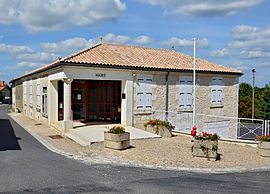
 Town hall | |
| Coordinates: 45°26′55″N 0°11′59″W / 45.4486°N .19972°W | |
| Country | France |
| Region | Nouvelle-Aquitaine |
| Department | Charente |
| Arrondissement | Cognac |
| Canton | Charente-Sud |
| Commune | Montmérac |
Area 1 | 14.18 km2 (5.47 sq mi) |
| Population (2019)[1] | 490 |
| • Density | 35/km2 (89/sq mi) |
| Time zone | UTC+01:00 (CET) |
| • Summer (DST) | UTC+02:00 (CEST) |
| Postal code | 16300 |
| Elevation | 61–147 m (200–482 ft) (avg. 145 m or 476 ft) |
| 1 French Land Register data, which excludes lakes, ponds, glaciers > 1 km2 (0.386 sq mi or 247 acres) and river estuaries. | |
Montchaude (French pronunciation: [mɔ̃ʃod]) is a former commune in the Charente department in southwestern France. On 1 January 2016, it was merged into the new commune Montmérac.[2]
Population
|
|
See also
References
- ^ Téléchargement du fichier d'ensemble des populations légales en 2019, INSEE
- ^ Charente, Six communes nouvelles en Charente à compter du 1er janvier 2016 (in French)
Wikimedia Commons has media related to Montchaude.


