Minimarg: Difference between revisions
No edit summary |
No edit summary |
||
| Line 1: | Line 1: | ||
{{Infobox settlement |
{{Infobox settlement |
||
<!-- See Template:Infobox settlement for additional fields and descriptions --> |
<!-- See Template:Infobox settlement for additional fields and descriptions --> |
||
| name = Minimarg |
| name = Minimarg |
||
| native_name = Minimarg Valley<br /> |
| native_name = Minimarg Valley <br />{{nq|منی مارگ}} |
||
| settlement_type = [[Village]] |
| settlement_type = [[Village]] |
||
| image_skyline = File:Minimarg, Kashmir.jpg |
| image_skyline = File:Minimarg, Kashmir.jpg |
||
| Line 13: | Line 13: | ||
| map_caption = |
| map_caption = |
||
| coordinates = {{coord|34.7908|75.0799|display=inline}} |
| coordinates = {{coord|34.7908|75.0799|display=inline}} |
||
| pushpin_map = Kashmir |
| pushpin_map = Azad Kashmir |
||
| pushpin_label_position = <!-- left, right, top, bottom, none --> |
| pushpin_label_position = <!-- left, right, top, bottom, none --> |
||
| pushpin_map_alt = |
| pushpin_map_alt = |
||
| pushpin_mapsize = |
| pushpin_mapsize = |
||
| pushpin_map_caption = Location in Kashmir |
| pushpin_map_caption = Location in Azad Kashmir |
||
| subdivision_type1 = [[Country]] |
| subdivision_type1 = [[Country]] |
||
| subdivision_name1 = [[ |
| subdivision_name1 = [[Pakistan]] |
||
| subdivision_type2 = [[Administrative units of |
| subdivision_type2 = [[Administrative units of Pakistan|Territory]] |
||
| subdivision_name2 = [[Kashmir]] |
| subdivision_name2 = [[Azad Kashmir]] |
||
| subdivision_type3 = |
| subdivision_type3 = |
||
| subdivision_name3 = |
| subdivision_name3 = Pakistan |
||
| Post Code (City ) = |
| Post Code (City ) = |
||
| population_total = |
| population_total = |
||
| Line 39: | Line 39: | ||
| leader_title1 = |
| leader_title1 = |
||
| leader_name1 = |
| leader_name1 = |
||
| area_code = + |
| area_code = +92 |
||
| area_code_type = [[List of dialing codes of |
| area_code_type = [[List of dialing codes of Pakistan|Calling code]] |
||
| timezone1 = [[ |
| timezone1 = [[Pakistan Standard Time|PST]] |
||
| utc_offset1 = +05: |
| utc_offset1 = +05:00 |
||
| website = |
| website = |
||
}} |
}} |
||
[[File:Beauty of minimarg village.png|thumb|Minimarg village]] |
[[File:Beauty of minimarg village.png|thumb|Minimarg village]] |
||
| ⚫ | '''Minimarg''' ({{lang-ur|{{nq|منی مارگ}}}}) is a village in the Neelum Valley, Azad Jammu & Kashmir. It is situated right to the Taobat approximately 90 km from [[Taobat]].<ref>{{cite web| url = https://www.dawn.com/news/1252881| title = Minimarg: Finding magic near the Line of Control - Multimedia - DAWN.COM}} </ref> The average elevation is 2,844.6 metres above sea level. |
||
'''Minimarg''' ({{lang-ur|==Welcome!== |
|||
Hello, Minimarg, and [[Wikipedia:Welcome, newcomers|welcome]] to Wikipedia. Thank you for your contributions; I hope you like the place and decide to stay! |
|||
'''Please read [[Wikipedia:Five pillars|The Five Pillars of Wikipedia]] to help you get to know this place''', and you might want to look at [[Wikipedia:What Wikipedia is not|What Wikipedia is not]] to see what is and isn't suitable for Wikipedia. |
|||
And remember, '''don't submit copyrighted work without permission'''. By submitting your work, you promise you wrote it yourself or copied it from public domain resources — this does not include most web pages. |
|||
| ⚫ | |||
[[File:Minimarg village.jpg|thumb|Minimarg village]] |
[[File:Minimarg village.jpg|thumb|Minimarg village]] |
||
| Line 61: | Line 53: | ||
==Language== |
==Language== |
||
People living in the region speak the [[ |
People living in the region speak the [[Shina language]]. |
||
[[File:Annual snowfall.jpg|thumb|Snowfall and landsliding]] |
[[File:Annual snowfall.jpg|thumb|Snowfall and landsliding]] |
||
| Line 73: | Line 65: | ||
{{Reflist}} |
{{Reflist}} |
||
{{coord|34|47|N|75|05|E|display=title|region: |
{{coord|34|47|N|75|05|E|display=title|region:PK_type:city_source:GNS-enwiki}} |
||
[[Category:Populated places in Neelam District]] |
[[Category:Populated places in Neelam District]] |
||
Revision as of 04:27, 11 February 2022
Minimarg
Minimarg Valley منی مارگ | |
|---|---|
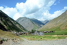
 A view of Minimarg village | |
| Coordinates: 34°47′27″N 75°04′48″E / 34.7908°N 75.0799°E | |
| Country | Pakistan |
| Territory | Azad Kashmir |
| Elevation | 2,844.6 m (9,332.7 ft) |
| Time zone | UTC+05:00 (PST) |
| Calling code | +92 |

Minimarg (Template:Lang-ur) is a village in the Neelum Valley, Azad Jammu & Kashmir. It is situated right to the Taobat approximately 90 km from Taobat.[1] The average elevation is 2,844.6 metres above sea level.

History
During the First Kashmir War in 1947–1948, a wing of the combined Gilgit Scouts and renegade 6th Infantry of the Jammu and Kashmir State Forces, called the 'Tiger Force', took control of Minimarg. They reached as far south as Bandipora in April 1948, but withdrew to Minimarg after the Indian Army's Operation Eraze.[2][3]
Language
People living in the region speak the Shina language.

Climate
July is warm with an average temperature of 19.8 °C. January is cold with an average temperature of -17.3 °C.
Economy
The dominant source of income is agriculture. Some people travel to other regions of the country to earn. Due to its landscape and climatic conditions the valley provides habitat for a variety of commercially important medicinal plants. A major source of income for people is the sale of natural herbs and potatoes.
References
- ^ "Minimarg: Finding magic near the Line of Control - Multimedia - DAWN.COM".
- ^ Cheema, Brig Amar (2015), The Crimson Chinar: The Kashmir Conflict: A Politico Military Perspective, Lancer Publishers, p. 85, ISBN 978-81-7062-301-4
- ^ Khanna, K. K. (2015), Art of Generalship, Vij Books India Pvt Ltd, p. 158, ISBN 978-93-82652-93-9

