Glencullen: Difference between revisions
Adding 2022 population as per the Census |
Guliolopez (talk | contribs) Electoral division is significantly broader in scope than this article. ED includes all of Stepaside, parts of Foxrox, Leopardstown and Sandyford. As well as ALL of Kilternan. |
||
| Line 25: | Line 25: | ||
|area_total_km2 = |
|area_total_km2 = |
||
|population_as_of = 2022 |
|population_as_of = 2022 |
||
|population_total = |
|population_total = 376 |
||
|population_blank1_title = Village |
|||
|population_blank1 = 376 |
|||
|population_blank2_title = Electoral division |
|||
|population_blank2 = 23596 |
|||
|population_footnotes = <ref name="cso2022">{{cite web|title=Census 2022 - F1008 Population by Electoral Divisions in County Dublin, by Birthplace|work=Central Statistics Office Census 2022 Reports |publisher=[[Central Statistics Office (Ireland)|Central Statistics Office Ireland]] |date=August 2023 |url=https://data.cso.ie/table/F1008 |access-date=9 September 2023 }}</ref> |
|population_footnotes = <ref name="cso2022">{{cite web|title=Census 2022 - F1008 Population by Electoral Divisions in County Dublin, by Birthplace|work=Central Statistics Office Census 2022 Reports |publisher=[[Central Statistics Office (Ireland)|Central Statistics Office Ireland]] |date=August 2023 |url=https://data.cso.ie/table/F1008 |access-date=9 September 2023 }}</ref> |
||
|area_code = 01 (+3531) |
|area_code = 01 (+3531) |
||
| Line 40: | Line 36: | ||
'''Glencullen''' ({{Irish place name|Gleann Cuilinn|valley of the holly}}) is a village and [[townland]] in the county of [[Dún Laoghaire–Rathdown]] in south [[County Dublin]], [[Republic of Ireland|Ireland]]. It is also the name of the valley above one end of which the village sits, and from which it takes its name, and is on the [[R116 road]], on the slopes of [[Two Rock|Two Rock Mountain]]. The highest point of the area is at a height of about {{convert|300|m|ft}},<ref>[http://maps.osi.ie/publicviewer/#V1,718908,720508,4,1 Ordnance Survey Ireland: Public Map Viewer] {{Webarchive|url=https://web.archive.org/web/20120829114800/http://maps.osi.ie/publicviewer/#V1,718908,720508,4,1 |date=2012-08-29 }} (centered on Glencullen)</ref> making Glencullen one of the [[Extreme points of Ireland|highest villages in Ireland]].<ref name="high">{{cite web|title=Dublin Mountain Trail Running Festival|publisher=Running Calendar Ireland|date=June 2023 |url=https://www.runningcalendar.ie/event/dublin-mountain-trail-running-festival/|access-date=9 September 2023 }}</ref> |
'''Glencullen''' ({{Irish place name|Gleann Cuilinn|valley of the holly}}) is a village and [[townland]] in the county of [[Dún Laoghaire–Rathdown]] in south [[County Dublin]], [[Republic of Ireland|Ireland]]. It is also the name of the valley above one end of which the village sits, and from which it takes its name, and is on the [[R116 road]], on the slopes of [[Two Rock|Two Rock Mountain]]. The highest point of the area is at a height of about {{convert|300|m|ft}},<ref>[http://maps.osi.ie/publicviewer/#V1,718908,720508,4,1 Ordnance Survey Ireland: Public Map Viewer] {{Webarchive|url=https://web.archive.org/web/20120829114800/http://maps.osi.ie/publicviewer/#V1,718908,720508,4,1 |date=2012-08-29 }} (centered on Glencullen)</ref> making Glencullen one of the [[Extreme points of Ireland|highest villages in Ireland]].<ref name="high">{{cite web|title=Dublin Mountain Trail Running Festival|publisher=Running Calendar Ireland|date=June 2023 |url=https://www.runningcalendar.ie/event/dublin-mountain-trail-running-festival/|access-date=9 September 2023 }}</ref> |
||
Glencullen is in the civil parish of [[Kilternan]] and the barony and Poor Law Union of Rathdown. 376 people lived in the village itself as of the 2022 census |
Glencullen is in the civil parish of [[Kilternan]] and the barony and Poor Law Union of Rathdown. 376 people lived in the village itself as of the 2022 census.<ref name="cso2022"/> |
||
==Heritage== |
==Heritage== |
||
Revision as of 12:31, 13 September 2023
Glencullen
Gleann Cuilinn | |
|---|---|
Village | |
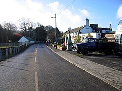
 Glencullen with Johnnie Fox's pub on the right | |
| Coordinates: 53°13′23″N 6°12′58″W / 53.223°N 6.216°W | |
| Country | Ireland |
| Province | Leinster |
| County | Dún Laoghaire–Rathdown |
| Elevation | 276 m (906 ft) |
| Population (2022)[1] | |
• Total | 376 |
| Eircode (Routing Key) | D18 |
| Area code | 01 (+3531) |
| Irish Grid Reference | O186206 |

Glencullen (Irish: Gleann Cuilinn, meaning 'valley of the holly') is a village and townland in the county of Dún Laoghaire–Rathdown in south County Dublin, Ireland. It is also the name of the valley above one end of which the village sits, and from which it takes its name, and is on the R116 road, on the slopes of Two Rock Mountain. The highest point of the area is at a height of about 300 metres (980 ft),[2] making Glencullen one of the highest villages in Ireland.[3]
Glencullen is in the civil parish of Kilternan and the barony and Poor Law Union of Rathdown. 376 people lived in the village itself as of the 2022 census.[1]
Heritage

There is a Bronze Age wedge tomb at Ballyedmonduff on the south-eastern slope of Two Rock Mountain. It is known locally as the giants grave. It is a rectangular chamber divided into three parts surrounded by a U-shaped double-walled kerb filled with stones. The tomb was excavated in the 1940s by Seán P. Ó Riordáin and Ruaidhrí De Valera when cremated bone, a polished stone hammer, flints and pottery were found.
Below Two Rock Mountain is the prominent South Dublin landmark of Three Rock Mountain, complete with its Communications Masts, some of which are visible from Glencullen.
Glencullen also has an important standing stone at Newtown Hill and also has an earthen burial mound dating from the same period as the wedge tomb at Ballyedmonduff.[4] Glencullen Standing Stone also known as Queen Mab is also located in the village.
Entertainment
At the centre of the village is Johnnie Fox's Pub, which was established in 1798, the year of the Irish Rebellion led by Theobald Wolfe Tone. The pub has an active business in Irish-themed entertainment, and draws substantial coach and car traffic.
Amenities
The part-time library is housed in a Carnegie building, dating back to 1907.
St. Patrick's National School (a national primary school) is in Glencullen.
Sport
The Stars of Erin (Irish: Réaltaí na hÉireann ) are the local Gaelic Athletic Association club. They were founded in 1903 and have two All Ireland Club titles, and are holders of the Paddy Mulligan Cup.[citation needed]
There is a nine-hole golf course and a mountain bike park (formerly a golf course).
Transport
The number 44B Dublin Bus service runs from the Dundrum Luas station to Glencullen.[5] There is also a private coach service run by the pub Johnnie Fox's nearby from Dublin City Centre to the pub.
History
In August 1841 the village was the centre of the agitation movement against Robert Peel's government when the "cabinet council" was convened at Fitzsimon's seat. Attendees included Viscount Morpeth and Frederick Romilly. During the Fenian Insurrection of 1867, the nine policemen of Glencullen barracks surrendered to the Irish Republic.[6]
People
Glencullen was home to the politician Christopher Fitzsimon, son-in-law of Daniel O'Connell[7]
Glencullen features heavily in Dennis Kennedy's memoirs entitled Square Peg.[8]
See also
References
- ^ a b "Census 2022 - F1008 Population by Electoral Divisions in County Dublin, by Birthplace". Central Statistics Office Census 2022 Reports. Central Statistics Office Ireland. August 2023. Retrieved 9 September 2023.
- ^ Ordnance Survey Ireland: Public Map Viewer Archived 2012-08-29 at the Wayback Machine (centered on Glencullen)
- ^ "Dublin Mountain Trail Running Festival". Running Calendar Ireland. June 2023. Retrieved 9 September 2023.
- ^ "History of Glencullen" (PDF). Archived from the original (PDF) on 13 July 2015. Retrieved 13 July 2015.
- ^ Dublin Bus Archived September 11, 2010, at the Wayback Machine
- ^ The Times, The Fenian Insurrection 9 March 1867
- ^ The Times, O'Connell and the People of Leicester, 6 August 1836
- ^ Square Peg – Dennis Kennedy


