Skaergaard intrusion: Difference between revisions
H2oArtichoke (talk | contribs) Linked to the article of geologic complexes |
H2oArtichoke (talk | contribs) Added a sentence about the preexisting geology of the region before the intrusion, linked to the article of gneiss, and added a source for this sentence, which is reference 7. |
||
| Line 6: | Line 6: | ||
and the development of layering.<ref>Wager, LR, [[George Malcolm Brown|Brown, GM]] (1967) Layered Igneous Rocks. WH Freeman, San Francisco, 588 pp.</ref><ref>McBirney, AR, Noyes, RM (1975) ''Crystallization and Layering of the Skaergaard Intrusion''. Journal of Petrology, v. 20, p. 487-554.</ref> |
and the development of layering.<ref>Wager, LR, [[George Malcolm Brown|Brown, GM]] (1967) Layered Igneous Rocks. WH Freeman, San Francisco, 588 pp.</ref><ref>McBirney, AR, Noyes, RM (1975) ''Crystallization and Layering of the Skaergaard Intrusion''. Journal of Petrology, v. 20, p. 487-554.</ref> |
||
The Skaergaard intrusion formed when [[Tholeiitic basalt|tholeiitic]] magma was emplaced about 55 million years ago,<ref>Brooks, CK, Gleadow, AJW (1977) ''A fission-track age for the Skaergaard intrusion and the age of the East Greenland basalts''. Geology, v. 5, p. 539-540.</ref> |
The Skaergaard intrusion formed when [[Tholeiitic basalt|tholeiitic]] magma was emplaced about 55 million years ago,<ref>Brooks, CK, Gleadow, AJW (1977) ''A fission-track age for the Skaergaard intrusion and the age of the East Greenland basalts''. Geology, v. 5, p. 539-540.</ref> |
||
during the initial opening of the [[North Atlantic Ocean]]. The body represents essentially a single pulse of magma, which crystallized from the bottom upward and the top downward. The intrusion is characterized by exceptionally well-developed [[cumulate rock|cumulate]] layering defined by variations in the abundance of crystallizing [[olivine]], [[pyroxene]], [[plagioclase]] and [[magnetite]]. |
during the initial opening of the [[North Atlantic Ocean]]. The body represents essentially a single pulse of magma, which crystallized from the bottom upward and the top downward, replacing the preexisting [[gneiss]].<ref>{{Cite journal |last=Stewart |first=Brian W. |last2=DePaolo |first2=Donald J. |date=1990 |title=Isotopic studies of processes in mafic magma chambers: II. The Skaergaard Intrusion, East Greenland |url=http://dx.doi.org/10.1007/bf00306438 |journal=Contributions to Mineralogy and Petrology |volume=104 |issue=2 |pages=125–141 |doi=10.1007/bf00306438 |issn=0010-7999}}</ref> The intrusion is characterized by exceptionally well-developed [[cumulate rock|cumulate]] layering defined by variations in the abundance of crystallizing [[olivine]], [[pyroxene]], [[plagioclase]] and [[magnetite]]. |
||
The Skaergaard is perhaps the simplest and smallest of a group of gabbroic [[Complex (geology)|complexes]] of similar age that occur along the central coast of [[Tunu|East Greenland]], which together with coeval [[flood basalt]]s are part of the North Atlantic [[large igneous province]]. |
The Skaergaard is perhaps the simplest and smallest of a group of gabbroic [[Complex (geology)|complexes]] of similar age that occur along the central coast of [[Tunu|East Greenland]], which together with coeval [[flood basalt]]s are part of the North Atlantic [[large igneous province]]. |
||
Revision as of 17:36, 26 October 2023
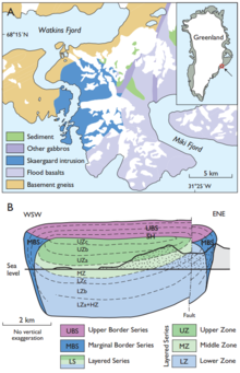
68°10′06″N 31°43′01″W / 68.1683°N 31.7169°W The Skaergaard intrusion is a layered igneous intrusion in the Kangerlussuaq area, East Greenland. It comprises various rock types including gabbro, ferro diorite, anorthosite and granophyre.

Discovered by Lawrence Wager[1] in 1931 during the British Arctic Air Route Expedition led by Gino Watkins, the intrusion has been important to the development of key concepts in igneous petrology, including magma differentiation and fractional crystallisation[2][3] and the development of layering.[4][5] The Skaergaard intrusion formed when tholeiitic magma was emplaced about 55 million years ago,[6] during the initial opening of the North Atlantic Ocean. The body represents essentially a single pulse of magma, which crystallized from the bottom upward and the top downward, replacing the preexisting gneiss.[7] The intrusion is characterized by exceptionally well-developed cumulate layering defined by variations in the abundance of crystallizing olivine, pyroxene, plagioclase and magnetite.
The Skaergaard is perhaps the simplest and smallest of a group of gabbroic complexes of similar age that occur along the central coast of East Greenland, which together with coeval flood basalts are part of the North Atlantic large igneous province.
See also
References
- ^ Brooks, CK (2005) The Skaergaard intrusion: from icon to precious metal deposit. Geology Today, v. 21, p. 218-221.
- ^ Wager, LR, Deer, WA (1939) Geological investigations in East Greenland Part III. The petrology of the Skaergaard Intrusion, Kangerdlugssuaq. Meddelselser om Grønland, v. 105, 346 pp.
- ^ McBirney, AR (1975) Differentiation of the Skaergaard intrusion. Nature, v. 253, p. 691-694.
- ^ Wager, LR, Brown, GM (1967) Layered Igneous Rocks. WH Freeman, San Francisco, 588 pp.
- ^ McBirney, AR, Noyes, RM (1975) Crystallization and Layering of the Skaergaard Intrusion. Journal of Petrology, v. 20, p. 487-554.
- ^ Brooks, CK, Gleadow, AJW (1977) A fission-track age for the Skaergaard intrusion and the age of the East Greenland basalts. Geology, v. 5, p. 539-540.
- ^ Stewart, Brian W.; DePaolo, Donald J. (1990). "Isotopic studies of processes in mafic magma chambers: II. The Skaergaard Intrusion, East Greenland". Contributions to Mineralogy and Petrology. 104 (2): 125–141. doi:10.1007/bf00306438. ISSN 0010-7999.
External links
