Ajloun Castle: Difference between revisions
added some information and links both internal and external Tags: Reverted Visual edit |
m Disambiguating links to Hospitaller (link changed to Knights Hospitaller) using DisamAssist. |
||
| Line 36: | Line 36: | ||
===12th-century Ayyubid castle=== |
===12th-century Ayyubid castle=== |
||
====Purpose==== |
====Purpose==== |
||
It was rebuilt as a castle in 1184 by [[Izz al-Din Usama]], a general in the army of [[Saladin]]. The castle controlled traffic along the road connecting [[Damascus]] and [[Lower Egypt|Egypt]].<ref>{{Cite book|url=https://archive.org/details/jordan0000tell|url-access=registration|page=[https://archive.org/details/jordan0000tell/page/173 173]|quote=Ajloun earthquake damage.|title=Jordan|last=Teller|first=Matthew|date=2002|publisher=Rough Guides|isbn=9781858287409|language=en}}</ref> According to Saladin's historian [[Baha ad-Din ibn Shaddad]], the fortress was primarily built in order to help the authorities in Damascus control the Bedouin tribes of the Jabal 'Auf. These enjoyed enough autonomy as to ally themselves to the [[Kingdom of Jerusalem|Crusaders]], and had at one point set up a 100-tent camp next to the [[Hospitaller]] castle of [[Belvoir Fortress|Belvoir]] on the opposite side of the Jordan Valley.<ref>Joseph M. Delaville Le Roulx, ''[[Cartulaire général de l'ordre des Hospitaliers]] de Saint-Jean de Jérusalem (1100-1301)'', vol. I, Paris 1894, p 395-396, No. 582 of 28 April 1180</ref> As such, Ajlun Castle is one of the very few Muslim fortresses built by the Ayyubids to protect their realm against Crusader incursions, which could come from [[Beisan]] or Belvoir in the west and from [[Al Karak|Karak]] in the south. |
It was rebuilt as a castle in 1184 by [[Izz al-Din Usama]], a general in the army of [[Saladin]]. The castle controlled traffic along the road connecting [[Damascus]] and [[Lower Egypt|Egypt]].<ref>{{Cite book|url=https://archive.org/details/jordan0000tell|url-access=registration|page=[https://archive.org/details/jordan0000tell/page/173 173]|quote=Ajloun earthquake damage.|title=Jordan|last=Teller|first=Matthew|date=2002|publisher=Rough Guides|isbn=9781858287409|language=en}}</ref> According to Saladin's historian [[Baha ad-Din ibn Shaddad]], the fortress was primarily built in order to help the authorities in Damascus control the Bedouin tribes of the Jabal 'Auf. These enjoyed enough autonomy as to ally themselves to the [[Kingdom of Jerusalem|Crusaders]], and had at one point set up a 100-tent camp next to the [[Knights Hospitaller|Hospitaller]] castle of [[Belvoir Fortress|Belvoir]] on the opposite side of the Jordan Valley.<ref>Joseph M. Delaville Le Roulx, ''[[Cartulaire général de l'ordre des Hospitaliers]] de Saint-Jean de Jérusalem (1100-1301)'', vol. I, Paris 1894, p 395-396, No. 582 of 28 April 1180</ref> As such, Ajlun Castle is one of the very few Muslim fortresses built by the Ayyubids to protect their realm against Crusader incursions, which could come from [[Beisan]] or Belvoir in the west and from [[Al Karak|Karak]] in the south. |
||
From its location, the fortress dominated a wide stretch of the northern [[Jordan Valley]], controlled the three main passages that led to it (Wadi Kufranjah, Wadi Rajeb and [[Cherith|Wadi al-Yabis]]), and protected the communication routes between southern Jordan and [[Syria (region)|Syria]]. It was built to contain the progress of the [[Kingdom of Jerusalem|Latin Kingdom]], which with the Lordship of [[Oultrejordain]] had gained a foothold in [[Transjordan (region)|Transjordan]], and as a retort to the castle of Belvoir a few miles south of the [[Sea of Galilee]]. Another major objective of the fortress was to protect the development and control of the iron mines of Ajlun. |
From its location, the fortress dominated a wide stretch of the northern [[Jordan Valley]], controlled the three main passages that led to it (Wadi Kufranjah, Wadi Rajeb and [[Cherith|Wadi al-Yabis]]), and protected the communication routes between southern Jordan and [[Syria (region)|Syria]]. It was built to contain the progress of the [[Kingdom of Jerusalem|Latin Kingdom]], which with the Lordship of [[Oultrejordain]] had gained a foothold in [[Transjordan (region)|Transjordan]], and as a retort to the castle of Belvoir a few miles south of the [[Sea of Galilee]]. Another major objective of the fortress was to protect the development and control of the iron mines of Ajlun. |
||
Revision as of 10:50, 30 December 2023
| Ajloun Castle قلعة عجلون | |
|---|---|
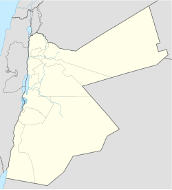
| Ajloun, Jordan | |
 Ajloun Castle | |
| Coordinates | 32°19′30.75″N 35°43′38.21″E / 32.3252083°N 35.7272806°E |
| Type | Castle |


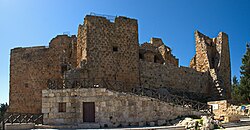
Ajloun Castle (Template:Lang-ar; transliterated: Qalʻat 'Ajloun), medieval name Qalʻat ar-Rabad, is a 12th-century Muslim castle situated in northwestern Jordan. It is placed on a hilltop belonging to the Mount Ajloun district, also known as Jabal 'Auf after a Bedouin tribe which had captured the area in the 12th century. From its high ground the castle was guarding three wadis which descend towards the Jordan Valley. It was built by the Ayyubids in the 12th century and enlarged by the Mamluks in the 13th.
Names
The name 'Ajlun goes back to a Christian monk who lived on this mountain in the Byzantine period.[1]
The castle has been the nucleus of a settlement which has grown to become the present town of Ajloun. The castle's developing faubourg led to its second name, Qalʻat ar-Rabad, "the castle of the faubourg" or "the castle with the suburbs".[2] This name still resonates in the surname of a large and reputable Christian family owning most of the agricultural lands in the direct vicinity of the castle until this day, the Al-Rabadis.
History
Byzantine monastery

Ajlun Castle is located on the site of an old monastery, traces of which were discovered during archaeological excavations. Tradition has it that the name 'Ajlun goes back to a Byzantine-period monk who lived in the area.
12th-century Ayyubid castle
Purpose
It was rebuilt as a castle in 1184 by Izz al-Din Usama, a general in the army of Saladin. The castle controlled traffic along the road connecting Damascus and Egypt.[3] According to Saladin's historian Baha ad-Din ibn Shaddad, the fortress was primarily built in order to help the authorities in Damascus control the Bedouin tribes of the Jabal 'Auf. These enjoyed enough autonomy as to ally themselves to the Crusaders, and had at one point set up a 100-tent camp next to the Hospitaller castle of Belvoir on the opposite side of the Jordan Valley.[4] As such, Ajlun Castle is one of the very few Muslim fortresses built by the Ayyubids to protect their realm against Crusader incursions, which could come from Beisan or Belvoir in the west and from Karak in the south.
From its location, the fortress dominated a wide stretch of the northern Jordan Valley, controlled the three main passages that led to it (Wadi Kufranjah, Wadi Rajeb and Wadi al-Yabis), and protected the communication routes between southern Jordan and Syria. It was built to contain the progress of the Latin Kingdom, which with the Lordship of Oultrejordain had gained a foothold in Transjordan, and as a retort to the castle of Belvoir a few miles south of the Sea of Galilee. Another major objective of the fortress was to protect the development and control of the iron mines of Ajlun.
Original outline
The original castle had four corner towers connected by curtain walls and a double gate. Arrow slits were incorporated in the thick walls and it was surrounded by a moat averaging 16 meters (about 52 feet) in width and 12–15 meters (about 40–50 feet) in depth.
13th century: expansion, Mongol destruction, restoration
After Usama's death, the castle was enlarged in AD 1214–15 by Aibak ibn Abdullah, the Mamluk governor. He added a new tower in the southeast corner and built the gate.
The castle lost its military importance after the fall of Karak in AD 1187 to the Ayyubids. In the middle of the 13th century AD, the castle was conceded to Yousef ibn Ayoub, emir of Aleppo and Damascus, who restored the northeastern tower and used the castle as an administrative center.
In 1260 AD, the Mongols destroyed sections of the castle, including its battlements. Soon after the victory of the Mamluks over the Mongols at Ain Jalut, Sultan ad-Dhaher Baibars restored the castle and cleared the fosse. The castle was used as a storehouse for crops and provisions. When Izz ad-Din Aibak was appointed governor, he renovated the castle as indicated by an inscription found in the castle's south-western tower.
Ottoman period
During the Ottoman period, a contingent of fifty soldiers was set inside the castle. During the first quarter of the 17th century, Prince Fakhr ad-Din al-Ma'ni II used it during his fight against Ahmad ibn Tarbay. He supplied the castle with a contingent and provided provisions and ammunition. In 1812, the Swiss traveller Johann Ludwig Burckhardt found the castle inhabited by around forty people.
Earthquakes and restoration
Two major destructive earthquakes struck the castle in 1837 and 1927. Recently, the Department of Antiquities of Jordan has sponsored a program of restoration and consolidation of the walls and has rebuilt the bridge over the fosse.
Tourism
Ajlun castle is open for tourism. Many areas of the castle can be explored. Tourists in Jordan often visit the castle. Inside there is also a museum exhibition with many interesting artifacts from the various time periods of the region.
Ajloun is also an ecological place, having the pine forests of Dibben area "consists of 13 km2 of rolling hill country dominated by open woodlands that are home to a diverse collection of plant and animal species". [5]
Ajloun Cable Car
Tour guide Ahlam Serhan highlights the unique perspective that the cable car offers in showcasing Ajloun’s historical and natural landmarks. By gliding through the air, visitors will gain a deeper understanding of the region’s rich history and cultural significance. Importantly, Serhan emphasizes that the cable car promotes sustainable tourism, as it minimizes the impact on Ajloun’s natural resources. Visitors can now appreciate the area’s beauty without disturbing the delicate ecosystem that sustains it.[1]
Gallery
-
General view of the castle atop Jabal 'Auf
-
General view, castle and mount
-
General view at night
-
Castle walls from outside
-
Moat, bridge, and outer gate
-
Bridge over the moat, outer gate
-
Second gate
-
Passage (stairs) ascending from inner gate, door to museum
-
Castle hall housing the museum
-
Museum: stone-carved door of ancient grave
-
Ajloun Castle Museum: ancient multi-wick oil lamp
-
Ajloun Castle Museum: Christian oil lamp, Byzantine period
-
Ajloun Castle Museum: Roman glass vessel
-
Ajloun Castle Museum: Roman glass object
-
Ajloun Castle Museum: preserved Byzantine mosaic floor
-
Inner view (corridor)
-
Inner view (door between corridor and room)
-
One of the watchtowers
-
Vaulted ceiling
-
Ajloun Mountains
-
Ajloun Mountains
References
- ^ Maurice Gaudefroy-Demombynes, La Syrie à l'époque des Mamelouks d'après les auteurs arabes, Bibliothèque archéologique et historique du Service des Antiquités et des Beaux-Arts en Syrie et au Liban, vol. III, Paris 1923, p 66
- ^ Johns, C.N. (Cedric Norman). Medieval 'Ajlun, p. 30.
- ^ Teller, Matthew (2002). Jordan. Rough Guides. p. 173. ISBN 9781858287409.
Ajloun earthquake damage.
- ^ Joseph M. Delaville Le Roulx, Cartulaire général de l'ordre des Hospitaliers de Saint-Jean de Jérusalem (1100-1301), vol. I, Paris 1894, p 395-396, No. 582 of 28 April 1180
- ^ Hussein, Ahmad (2021-07-12). "Ajlun: the green landscapes and the castle". yolojordan.com. Retrieved 2023-12-28.
Bibliography
- Darwish, Nazmieh Rida Tawfiq (1990). Jordan. Plurigraf Narni.


