Wola Piotrowa: Difference between revisions
No edit summary |
|||
| Line 7: | Line 7: | ||
subdivision_name = Poland| |
subdivision_name = Poland| |
||
image_seal =| |
image_seal =| |
||
subdivision_type1 = |
subdivision_type1 =[[Beskids]] | |
||
subdivision_name1 = Subcarpathian Voivodship| |
subdivision_name1 = Subcarpathian Voivodship| |
||
population_total = 220| |
population_total = 220| |
||
Revision as of 06:02, 4 April 2007
49°31′N 22°05′E / 49.517°N 22.083°E
Wola Piotrowa
Wola Piotrowa | |
|---|---|
village | |
 | |
| Country | Poland |
| Beskids | Subcarpathian Voivodship |
| Founded | 1526 |
| Population | |
• Total | 220 |


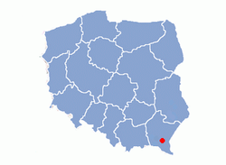
Wola Piotrowa– village in East Małopolska in the Lesser Beskid mountains, Bukowsko rural commune, latin parish in Bukowsko, protestans parish in loco.
Wola Piotrowa is about 17 miles from Sanok in south-west Polands. It is situated below the main watershed at the foot of the Słonne Mountain, and has an elevation of 340 metres. Situated in the Subcarpathian Voivodship (since 1999), previously in Krosno Voivodship (1975-1998) and Sanok district, (10 miles east of Sanok), located near the towns of Medzilaborce and Palota (in northeastern Slovakia).
Wola Piotrowa was founded in 1526 by Herburts family. During 966 - 1018, 1340 - 1772 (Ruthenian Voivodeship, sanoker county) and during 1918 - 1939 Zboiska was part of Poland. While during 1772 - 1918 it belonged to Austrian empire, later Austrian-Hungarian empire when double monarchy was introduced in Austria. This part of Poland was controlled by Austria for almost 120
years. At that time the area (including west and east of Subcarpathian Voivodship) was known as Galicia. In 1785 the village lands comprised 6 1 lan. There were 50 Greek Catholics, 267 Roman Catholics and 5 Jews. In 1899 the village lands comprised 3,43 sq km.
The village was burned down in the spring 1946 by the UPA.
The cemetery has a few headstones in it. The rural families are poor, agriculture is rarely profitable and low icome makes it diffcult for farms to invest in from improvements.

Most popular surnames in the region
Surnames from 1787 Cadastral Records : Chrząszcz, Ciękała, Hrynczak, Laban, Król, Mazur, Mielnik, Pyszyk, Piechanin, Rusińczak, Sałak, Ścieranka, Wasienko, Zielonka, Barnik, Bik, Bibowski, Bednarczyk, Woźniak, Gaździński, Halko, Gruchniak, Daniak, Daszyk, Dedzio, Dziuk, Zwoirzynny, Kamiński, Kapłon, Kaszyk, Kobelka, Kościsko, Łabik, Łaniak, Makuch, Mentus, Mojsej, Pasternak, Barnik, Bik, Paszkowski, Petreźnik, Przystasz, Świszcz, Trubik, Tulko, Chlebasz,
Twin cities
- Topoľovka
- Maizieres-les-Metz
- Time zone; UTC+1/SummerUTC+2
Linki zewnętrzne
