Gangapur City: Difference between revisions
No edit summary Tags: Mobile edit Mobile web edit |
Tags: Mobile edit Mobile web edit |
||
| Line 282: | Line 282: | ||
* [https://www.radinet.in/ Radinet] |
* [https://www.radinet.in/ Radinet] |
||
* [[RailTel|Railwire]] |
* [[RailTel|Railwire]] |
||
* [https://www.spiderlinkbroadband.com/ Spiderlink] |
|||
== External links == |
== External links == |
||
Revision as of 18:37, 2 June 2024
This article needs additional citations for verification. (January 2021) |
Gangapur City | |
|---|---|
| Kushalgarh | |
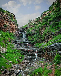
 Dhundheshwar Waterfall | |
| Nickname: GGC | |
| Coordinates: 26°28′18″N 76°42′57″E / 26.47171°N 76.71594°E | |
| Country | |
| State | Rajasthan |
| District | Gangapur |
| Founded by | Raja Kushaliram Haldiya |
| Named for | Brother of Raja Kushaliram, Gangaram |
| Government | |
| • Type | Government of Rajasthan |
| • Body | Nagar Parishad |
| • MLA | Ramkesh Meena
(INC) |
| • Chairman | Shivratan Agrawal
(BJP) |
| Area | |
• Total | 32 km2 (12 sq mi) |
| Elevation | 260 m (850 ft) |
| Population (2023) | |
• Total | 165,000 |
| • Density | 5,200/km2 (13,000/sq mi) |
| Languages | |
| • Official | Hindi |
| • Native | Braj Bhasha, Dhundhari (Rajasthani) |
| Time zone | UTC+5:30 (IST) |
| PIN | 322201,322202 |
| Telephone code | 07463 |
| Vehicle registration | RJ-25 |
| Sex ratio | 892 per 1000 ♂/♀ |
| Website | |

Gangapur City is a city and a municipal council located in Gangapur district in the Indian state of Rajasthan. It is the administrative headquarters of Gangapur district. It is famous for its Sweet Cuisine Kheermohan and newly built Kushalgarh Baba Shyam Temple.
History
Gangapur was reportedly named Kushalgarh (Hindi: कुशालगढ़); by King Kushaliram Haldiya. Gangapur took its current name from Kushaliram's brother, Gangaram. In older days, Gangapur City was the cultural capital of Jaipur State and was known as "The Jugad of the East". Today, Gangapur is primarily known for being an important part of the West Central Railway and newly built Shyam Baba Temple.
Geography
Gangapur City is located in the eastern part of Rajasthan; it is situated 140 km from Jaipur (The Capital of Rajasthan). The city's area is about 25 km² and has an average elevation of 1,624 feet.
Demographics
The 2011 Census of India considered Gangapur City as an urban agglomeration. The city has a population of 165,000 in the year 2023; males constitute 53% of the population and females constitute 47%.
Hindi is the Official Language of Gangapur City and here a mixture of Braj Bhasha and Dhundhari (Rajasthani) is primarily spoken.
| Year | Population |
|---|---|
| 1891 | |
| 1901 | |
| 1941 | |
| 1951 | |
| 1961 | |
| 1971 | |
| 1981 | |
| 1991 | |
| 2001 | |
| 2011 | |
| 2021 | |
| 2023 |
Literacy rates
The average literacy rate in Gangapur is 82.12%.
Religions
Hinduism is majority religion in Gangapur City, with 71.91% of the city as followers. Islam is the second most common religion, with 26.32% following it in the city.[1]
| Religion | Total | Percentage |
|---|---|---|
| Hindu | 1,18,651 | 71.91% |
| Muslims | 43,428 | 26.32% |
| Jain | 1,617 | 0.98% |
| Not Stated | 858 | 0.52% |
| Christian | 247 | 0.15% |
| Sikh | 132 | 0.08% |
| Buddhist | 66 | 0.04% |
| Others | 7 | 0.004% |

Climate
Gangapur City is in a subtropical dry climate that experiences summer, winter, and the wet season. Temperature may rise above 40°C in summers and can be low as 5°C in winters. The average precipitation is 24.48 cm. Humidity is about 5–10% in summers and rises to about 75% in rainy seasons.
| Climate data for Gangapur City | |||||||||||||
|---|---|---|---|---|---|---|---|---|---|---|---|---|---|
| Month | Jan | Feb | Mar | Apr | May | Jun | Jul | Aug | Sep | Oct | Nov | Dec | Year |
| Mean daily maximum °C (°F) | 20 (68) |
25 (77) |
34 (93) |
38 (100) |
41 (106) |
48 (118) |
36 (97) |
34 (93) |
36 (97) |
36 (97) |
31 (88) |
27 (81) |
34 (93) |
| Mean daily minimum °C (°F) | 8 (46) |
12 (54) |
18 (64) |
23 (73) |
27 (81) |
29 (84) |
27 (81) |
26 (79) |
25 (77) |
20 (68) |
15 (59) |
9 (48) |
20 (68) |
| Average precipitation cm (inches) | 0.35 (0.14) |
0.27 (0.11) |
0.32 (0.13) |
0.35 (0.14) |
0.6 (0.2) |
3.26 (1.28) |
8.89 (3.50) |
6.44 (2.54) |
3.42 (1.35) |
0.45 (0.18) |
0.07 (0.03) |
0.06 (0.02) |
24.48 (9.62) |
| Source: Foreca | |||||||||||||
Business
Major industries are related to Food processing and Agro Processing sector. Gangapur City is famous for its sweet Kheermohan (खीरमोहन) which was invented and started by a sweet maker name Babulal Halwai near about 1950. Around 145 units are in Gangapur City and nearby villages.
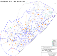
Gangapur City Wards Map

Gangapur City had 40 wards before 2019, but it now has 60 wards.
Transportation

Railways
Gangapur City is a railway station on the Delhi–Kota–Vadodara–Mumbai railway line and it is abbreviated as GGC. Many of the major trains on this route stop at the station. It is in the West Central Railway Zone under the Kota Division. Gangapur City is directly connected to major cities like Delhi, Mumbai, Jaipur, Kota, Agra, Indore, Mathura, Patna, Jammu, Amritsar, and Udaipur.
Station also serve as only railway source to places like Karauli, Sapotara, Bamanwas, Lalsot, Kailadevi, Piplai which did not have railway connectivity.
A new railway line is under construction which links Dausa and Gangapur City to connect Gangapur City to the Ahmedabad Junction railway station, in order to decrease travel time to cities like Jaipur, Jodhpur, and Ahmedabad and provide railway connectivity to areas like Lalsot, Piplai, and Bamanwas. Work of this Railway Line is supposed to be completed till 2024.
Another railway line has been proposed between Dholpur and Gangapur City to connect Gangapur City to the Delhi–Bhopal–Mumbai rail route and to provide connectivity to Karauli.
Roadways
Gangapur City has a Rajasthan roadways bus stand for Rajasthan government buses and a private bus stand for privately owned buses. Gangapur City has regular government and private buses to cities like Jaipur, Dausa, Karauli, Dholpur, Gwalior, Ajmer, Pushkar, Hindaun, Alwar, Bikaner, Bhilwara, Sikar and Sawai Madhopur.
Major roads passing through Gangapur City are:
- National Highway 23: Dholpur–Karauli–Gangapur–Lalsot–Kothun
- Rajasthan SH-1: Jhalawar–Kota–Sawai Madhopur–Gangapur City–Bharatpur
- Rajasthan SH-25: Gangapur City–Sikandra–Bandikui–Rajgarh–Alwar–Tijara–Bhiwadi–Daruhera
The distances of major cities from Gangapur City are:
- Jaipur: 141 km
- Sawai Madhopur: 75 km
- Bharatpur: 145 km
- Mathura: 180 km
- Agra: 160 km
- Kota: 206 km
- Indore: 570 km
- New Delhi: 238 km
- Udaipur: 458 km
- Ajmer: 274 km
- Karauli: 34 km
- Gwalior: 203 km
- Alwar: 142 km
- Dausa: 85 km
- Sikar: 265 km
Airways
The nearest airports to the city are Jaipur International Airport in Jaipur and Indira Gandhi International Airport in New Delhi.
Medical facilities
Gangapur City has a Government Hospital situated in Sursagar, which has an operation theatre, post-mortem room, maternity ward, and laboratory. It also has more than 5 Multi Speciality hospitals. Riya hospital, Garg hospital etc.
Banking
All major Indian banks have branches in Gangapur City.
- Allahabad Bank
- Axis Bank
- Bank of Baroda
- Baroda Rajasthan Kshetriya Gramin Bank
- Central Bank of India
- Canara Bank
- HDFC Bank
- ICICI Bank
- Indian Bank
- Indian Overseas Bank
- Indusland Bank
- Oriental Bank of Commerce
- Punjab National Bank
- State Bank of India
- Union Bank of India
- UCO Bank
- United Bank of India
- Yes Bank
Media
Dainik Bhaskar, Dainik Navajyoti and Rajasthan Patrika are the major newspapers read in Gangapur City, which are printed in the city. Other newspapers include The Times of India, Bajriya Ki Bhore, Badti Kalam, Rashtradut, Kushalgarh Ka Suraj. Chamkti Aankhe and Dainik Jagran.
G News Portal is the mostly watched news portal of Gangapur City, which shows live news of local incidents.
Internet Service Provider
External links
- https://www.gangapurcity.rajasthan.gov.in/home
- https://www.gangapur.city
- https://www.bhaskar.com/local/rajasthan/sawai-madhopur/gangapur/
- https://geoiq.io/places/Gangapur-City-(M)/yQSgXcvBJm
- https://www.giveindia.org/all-ngos/rajasthan/gangapur-city/
- https://www.mapsofindia.com/maps/rajasthan/gangapur.html
- https://women.raftaar.in/ghumne-ki-jagah/rajasthan/gangapur_city
References
- ^ "Gangapur City Population Census 2011 | Rajasthan". census2011.co.in. Retrieved 29 September 2016.


