Łomna, Nowy Dwór Mazowiecki County: Difference between revisions
Appearance
Content deleted Content added
m →top: Format administrative division links, remove DEFAULTSORTKEY as per WP:SORTKEY, remove One Source for stubs, minor formatting changes (AWB) |
|||
| Line 5: | Line 5: | ||
| image_skyline = Łomna kościół (4).jpg |
| image_skyline = Łomna kościół (4).jpg |
||
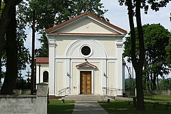
| image_caption = Saint Nicholas church in Łomna |
| image_caption = Saint Nicholas church in Łomna |
||
| subdivision_type = [[ |
| subdivision_type = [[List of sovereign states|Country]] |
||
| subdivision_name = {{POL}} |
| subdivision_name = {{POL}} |
||
| subdivision_type1 = [[Voivodeships of Poland|Voivodeship]] |
| subdivision_type1 = [[Voivodeships of Poland|Voivodeship]] |
||
| Line 16: | Line 16: | ||
| pushpin_map = Poland |
| pushpin_map = Poland |
||
| pushpin_label_position = bottom |
| pushpin_label_position = bottom |
||
| elevation_m = |
| elevation_m = |
||
| population_total = |
| population_total = |
||
| timezone = [[Central European Time|CET]] |
| timezone = [[Central European Time|CET]] |
||
| utc_offset = +1 |
| utc_offset = +1 |
||
Latest revision as of 06:30, 15 November 2024
Łomna | |
|---|---|
Village | |
 Saint Nicholas church in Łomna | |
| Coordinates: 52°22′57″N 20°46′34″E / 52.38250°N 20.77611°E | |
| Country | |
| Voivodeship | Masovian |
| County | Nowy Dwór |
| Gmina | Czosnów |
| Time zone | UTC+1 (CET) |
| • Summer (DST) | UTC+2 (CEST) |
| Vehicle registration | WND |
Łomna [ˈwɔmna] is a village in the administrative district of Gmina Czosnów, within Nowy Dwór County, within the Warsaw metropolitan area, in Masovian Voivodeship, in east-central Poland.[1] It is situated on the left bank of the Vistula River,[2] approximately 3 kilometres (2 mi) south-east of Czosnów, 10 km (6 mi) south-east of Nowy Dwór Mazowiecki, and 24 km (15 mi) north-west of Warsaw.
History
[edit]In 1135, the village was granted to the abbey in Czerwińsk nad Wisłą.[2]
In 1827, the village had a population of 465.[2]
A khachkar was unveiled in Łomna in 2023 (see also: Armenians in Poland).[3]
References
[edit]- ^ "Central Statistical Office (GUS) - TERYT (National Register of Territorial Land Apportionment Journal)" (in Polish). 2008-06-01.
- ^ a b c Słownik geograficzny Królestwa Polskiego i innych krajów słowiańskich, Tom V (in Polish). Warszawa. 1884. p. 691.
{{cite book}}: CS1 maint: location missing publisher (link) - ^ "Chaczkar w Łomnej". Awedis (in Polish). No. 53. 2022. p. 11.


