Ras Doumeira: Difference between revisions
Appearance
Content deleted Content added
Correction Tags: Visual edit Mobile edit Mobile web edit |
|||
| Line 8: | Line 8: | ||
| map_size = 250px |
| map_size = 250px |
||
| map_caption = Map of ''Ras Doumeira'' with the ''[[de facto]]'' border |
| map_caption = Map of ''Ras Doumeira'' with the ''[[de facto]]'' border |
||
| location = [[ |
| location = [[Eritrea]] |
||
| water_bodies = |
| water_bodies = |
||
| coordinates = {{coord|12|42|40|N|43|8|0|E|region:ER|display=inline, title}} |
| coordinates = {{coord|12|42|40|N|43|8|0|E|region:ER|display=inline, title}} |
||
Latest revision as of 20:31, 31 December 2024
This article needs additional citations for verification. (March 2018) |
Ras Doumeira
| |
|---|---|
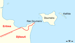
 Map of Ras Doumeira with the de facto border | |
| Coordinates: 12°42′40″N 43°8′0″E / 12.71111°N 43.13333°E | |
| Location | Eritrea |
| Native name | |
Ras Doumeira (Cape Doumeira, Somali: Raas Dumeera) is a geographic cape that extends into the Red Sea, towards the Doumeira Islands. The area is in the north of Djibouti and also border Eritrea, and was the subject of the 2008 border dispute between the two countries. In September 2018 ten years after the conflict, it was announced that Djibouti and Eritrea agreed to normalize their relations. [1]
References
[edit]- ^ "US condemns Eritrea 'aggression'". 12 June 2008. Retrieved 15 June 2008.
