Portal:North West England/Selected article/3: Difference between revisions
Removed extra space |
update |
||
| Line 1: | Line 1: | ||
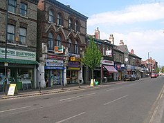
[[Image:Withington centre.jpg|237px|right|Withington village centre]] |
|||
[[Image:StJames - Didsbury.jpg|190px|right]]'''Didsbury''' ({{IPAEng|ˈdɪdzbʌri}}) is a [[Suburb|suburban area]] of the [[Manchester|City of Manchester]], in [[North West England|North West]] [[England]]. It is {{convert|4.5|mi|km|1}} south of [[Manchester City Centre]], and has a population of about 14,000. The area is intersected by [[Wilmslow Road, Manchester|Wilmslow Road]], said by some analysts to be the busiest bus corridor in Europe. |
|||
'''[[Withington]]''' is a [[village]] in the [[City of Manchester]], in [[North West England|North West]] [[England]]. It lies {{convert|4|mi|km|1}} immediately south of [[Manchester City Centre]], about {{convert|0.4|mi|km|1}} south of [[Fallowfield]], {{convert|0.5|mi|km|1}} north-east of [[Didsbury]], and {{convert|1|mi|km|1}} east of [[Chorlton-cum-Hardy]], near the centre-to-south edges of the [[Greater Manchester]] [[conurbation]]; it is in the [[Manchester Withington (UK Parliament constituency)|Manchester Withington]] [[parliamentary constituency]]. Withington is a [[Commuter town|dormitory village]] consisting of a resident population slightly over 14,000 people. |
|||
In the early 13th century, Withington occupied a [[Manorialism|feudal estate]] that included the townships of Withington, [[Chorlton-cum-Hardy]], [[Moss Side]], [[Rusholme]], [[Burnage]], [[Denton, Greater Manchester|Denton]] and [[Haughton, Greater Manchester|Haughton]], ruled by the Hathersage, Longford and Tatton families,<ref>{{cite book |last= Sussex & Helm |title= Looking Back at Withington and Didsbury |pages=45 |publisher= Willow |date= 1988 |id= ISBN 0-946361-25-8}}</ref> and within the [[Historic counties of England|historic county boundaries]] of [[Lancashire]].<ref>{{cite web |url=http://www.gmcro.co.uk/guides/gazette/gazframe.htm |title=A select gazetteer of local government areas, Greater Manchester County|author=Anon|publisher=[[Greater Manchester County Records Office]]|accessdate=2008-03-16|date=[[2003]]-[[07-31]]}}</ref> |
|||
Didsbury is considered to be a desireable residential area, predominantly populated by young professionals, families and students. |
|||
Withington was largely rural until the mid-nineteenth century, in which it experienced rapid [[socioeconomic]] development and [[urbanisation]] due to the [[Industrial Revolution]], and Manchester's [[History_of_manchester#The_Industrial_Revolution|growing level]] of [[industrialisation]]. Introduced into the [[History_of_manchester#Further expansion|inner boundaries of Manchester]] in 1904,<ref>{{cite web|url=http://www.withington.net/history.htm|title=Withington history|publisher=Unknown|accessdate=2008-03-16|date=2001}}</ref><ref>{{cite web|url=http://www.gmcro.co.uk/guides/gazette/gazframe.htm|title=Places in the Greater Manchester Area|publisher=Greater Manchester Gazetteer Index|date=[[2001]]|accessdate=2008-03-17}}</ref> Withington was integrated into the city forty-five years after it gained [[City status in the United Kingdom|city status]]. |
|||
The Towers, now known as the Shirley Institute, was once the home of engineer [[Daniel Adamson]]—the driving force behind the [[Manchester Ship Canal]] project—and the venue where the decision to build the canal was taken. The house was designed by Salford architect [[Thomas Worthington (architect)|Thomas Worthington]], for the editor and proprietor of the ''[[Manchester Guardian]]'', [[John Edward Taylor]]. The [[Royal Society for the Protection of Birds]] was formed in Didsbury in 1889. |
|||
<br> |
|||
<small>'''[[Didsbury|Read more...]]'''</small><br> |
|||
<div class="noprint" style="text-align:left;margin-right:10px;margin-bottom:4px;">'''[[Withington|Read more...]]'''</div> |
|||
Revision as of 13:53, 25 March 2008

Withington is a village in the City of Manchester, in North West England. It lies 4 miles (6.4 km) immediately south of Manchester City Centre, about 0.4 miles (0.6 km) south of Fallowfield, 0.5 miles (0.8 km) north-east of Didsbury, and 1 mile (1.6 km) east of Chorlton-cum-Hardy, near the centre-to-south edges of the Greater Manchester conurbation; it is in the Manchester Withington parliamentary constituency. Withington is a dormitory village consisting of a resident population slightly over 14,000 people.
In the early 13th century, Withington occupied a feudal estate that included the townships of Withington, Chorlton-cum-Hardy, Moss Side, Rusholme, Burnage, Denton and Haughton, ruled by the Hathersage, Longford and Tatton families,[1] and within the historic county boundaries of Lancashire.[2]
Withington was largely rural until the mid-nineteenth century, in which it experienced rapid socioeconomic development and urbanisation due to the Industrial Revolution, and Manchester's growing level of industrialisation. Introduced into the inner boundaries of Manchester in 1904,[3][4] Withington was integrated into the city forty-five years after it gained city status.
- ^ Sussex & Helm (1988). Looking Back at Withington and Didsbury. Willow. p. 45. ISBN 0-946361-25-8.
- ^ Anon (2003-07-31). "A select gazetteer of local government areas, Greater Manchester County". Greater Manchester County Records Office. Retrieved 2008-03-16.
{{cite web}}: Check date values in:|date=(help) - ^ "Withington history". Unknown. 2001. Retrieved 2008-03-16.
- ^ "Places in the Greater Manchester Area". Greater Manchester Gazetteer Index. 2001. Retrieved 2008-03-17.
{{cite web}}: Check date values in:|date=(help)
