Zamarski: Difference between revisions
Appearance
Content deleted Content added
correcting location/pronunciation/refs |
m link |
||
| Line 65: | Line 65: | ||
| last = Londzin |
| last = Londzin |
||
| first = Józef |
| first = Józef |
||
| |
| authorlink = |
||
| title = Kościoły drewniane na Śląsku Cieszyńskim |
| title = Kościoły drewniane na Śląsku Cieszyńskim |
||
| publisher = Dziedzictwo błog. Jana Sarkandra |
| publisher = Dziedzictwo błog. Jana Sarkandra |
||
| |
| year = 1932 |
||
| location = Cieszyn |
| location = Cieszyn |
||
| pages = 387–393 |
| pages = 387–393 |
||
| url = http://www. |
| url = http://www.sbc.org.pl/dlibra/docmetadata?id=10927&from=&dirids=110&ver_id=592382&lp=1&QI=1E9A46D2674AA878F51B05D5968295F1-12 |
||
| doi = |
| doi = |
||
| |
| oclc = 297540848 }} |
||
{{Gmina Hażlach}} |
{{Gmina Hażlach}} |
||
| Line 81: | Line 81: | ||
[[Category:Villages in Cieszyn County]] |
[[Category:Villages in Cieszyn County]] |
||
{{Silesian-geo-stub}} |
{{Silesian-geo-stub}} |
||
Revision as of 23:39, 22 January 2010
Zamarski | |
|---|---|
Village | |
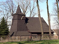
 Saint Roch wooden church | |
| Country | Poland |
| Voivodeship | Silesian |
| County | Cieszyn |
| Gmina | Hażlach |
| First mentioned | 1223 |
| Government | |
| • Mayor | Iwona Boruta |
Area | 8.64 km2 (3.34 sq mi) |
| Elevation | 388 m (1,273 ft) |
| Population (2007) | 1,280 |
| • Density | 150/km2 (380/sq mi) |
| Time zone | UTC+1 (CET) |
| • Summer (DST) | UTC+2 (CEST) |
| Postal code | 43-419 |
| Car plates | SCI |
Audio file "Zamarski.ogg" not found is a village in Gmina Hażlach, Cieszyn County in Silesian Voivodeship, southern Poland. It has a population of 1,280 (2007) and lies in the historical region of Cieszyn Silesia.
It was first mentioned in a written document in 1223. There is a wooden Saint Roch Catholic church built in 1731 in the village.
References
- Londzin, Józef (1932). Kościoły drewniane na Śląsku Cieszyńskim. Cieszyn: Dziedzictwo błog. Jana Sarkandra. pp. 387–393. OCLC 297540848.


