Hurricane Gilma (1994): Difference between revisions
→Meteorological history: more |
→Meteorological history: more |
||
| Line 20: | Line 20: | ||
==Meteorological history== |
==Meteorological history== |
||
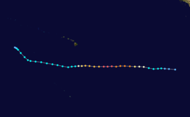
{{storm path|Gilma 1994 track.png}} |
{{storm path|Gilma 1994 track.png}} |
||
Hurricane Gilma originated from a [[tropical wave]] that moved off the coast of Africa and traversed the Atlantic Ocean during the second week of July 1994. The wave was of little note until it crossed [[Central America]] and entered the [[Pacific hurricane|Northeastern Pacific hurricane basin]] on July 15-16. [[Atmospheric convection|Convection]] began to increase; however, the system remained disorganized. Tracking westward, gradual development took place, leading to the [[Dvorak technique|Dvorak classification]] being initiated on July 20. Several hours later, the [[National Hurricane Center]] (NHC) designated the system as Tropical Depression Seven-E.<ref name="PR1">{{cite web|author=Richard J. Pasch|publisher=National Hurricane Center|date=January 20, 1995|accessdate=January 3, 2010|title=Hurricane Gilma Preliminary Report (Page 1)|url=http://www.nhc.noaa.gov/archive/storm_wallets/epacific/ep1994-prelim/gilma/prelim01.gif}}</ref> A strong [[Ridge (meteorology)|ridge]] situated north of the depression steered the system steadily westward.<ref>{{cite web|author=Miles B. Lawrence|publisher=National Hurricane Center|date=July 21, 1994|accessdate=January 3, 2010|title=Tropical Depression Seven-E Discussion One|url=http://www.nhc.noaa.gov/archive/storm_wallets/epacific/ep1994/gilma/tropdisc/nep0794.001}}</ref> This movement would remain the same throughout most of the storm's existence.<ref name="PR1"/> |
Hurricane Gilma originated from a [[tropical wave]] that moved off the coast of Africa and traversed the Atlantic Ocean during the second week of July 1994. The wave was of little note until it crossed [[Central America]] and entered the [[Pacific hurricane|Northeastern Pacific hurricane basin]] on July 15-16. [[Atmospheric convection|Convection]] began to increase; however, the system remained disorganized. Tracking westward, gradual development took place, leading to the [[Dvorak technique|Dvorak classification]] being initiated on July 20. Several hours later, the [[National Hurricane Center]] (NHC) designated the system as Tropical Depression Seven-E.<ref name="PR1">{{cite web|author=Richard J. Pasch|publisher=National Hurricane Center|date=January 20, 1995|accessdate=January 3, 2010|title=Hurricane Gilma Preliminary Report (Page 1)|url=http://www.nhc.noaa.gov/archive/storm_wallets/epacific/ep1994-prelim/gilma/prelim01.gif}}</ref> A strong [[Ridge (meteorology)|ridge]] situated north of the depression steered the system steadily westward.<ref>{{cite web|author=Miles B. Lawrence|publisher=National Hurricane Center|date=July 21, 1994|accessdate=January 3, 2010|title=Tropical Depression Seven-E Discussion One|url=http://www.nhc.noaa.gov/archive/storm_wallets/epacific/ep1994/gilma/tropdisc/nep0794.001}}</ref> This movement would remain the same throughout most of the storm's existence.<ref name="PR1"/> The depression was initially hard to locate due to its large size.<ref>{{cite web|author=Edward N. Rappaport|publisher=National Hurricane Center|date=July 21, 1994|accessdate=January 3, 2010|title=Tropical Depression Seven-E Discussion Two|url=http://www.nhc.noaa.gov/archive/storm_wallets/epacific/ep1994/gilma/tropdisc/nep0794.002}}</ref> |
||
Following an increase in organization, the depression intensified into a tropical storm early on July 22, at which time it was [[tropical cyclone naming|named]] Gilma.<ref name="PR1"/> Deep convection developed around the [[Eye (cyclone)|center of circulation]] throughout the day and [[Rainband|banding features]] became apparent on the west and south sides of the storm.<ref>{{cite web|author=Edward N. Rappaport|publisher=National Hurricane Center|date=July 22, 1994|accessdate=January 3, 2010|title=Tropical Storm Gilma Discussion Six|url=http://www.nhc.noaa.gov/archive/storm_wallets/epacific/ep1994/gilma/tropdisc/nep0794.006}}</ref> Only 24 hours after becoming a tropical storm, Gilma quickly intensified into a hurricane.<ref name="PR1"/> Low [[wind shear]] and warm [[sea surface temperature]]s, recorded up to {{convert|29|C|F|abbr=on}} by a ship near the hurricane, allowed the storm to undergo [[Rapid deepening|rapid intensification]].<ref>{{cite web|author=Lixion A. Avila|publisher=National Hurricane Center|date=July 22, 1994|accessdate=January 3, 2010|title=Hurricane Gilma Discussion Eight|url=http://www.nhc.noaa.gov/archive/storm_wallets/epacific/ep1994/gilma/tropdisc/nep0794.008}}</ref> This rate of intensification continued throughout most of July 23, resulting in the system attaining [[SSHS#Category 4|Category 4 status]] on the [[Saffir–Simpson Hurricane Scale]].<ref name="PR1"/> |
|||
==Forecasting, impact and records== |
==Forecasting, impact and records== |
||
Revision as of 16:50, 3 January 2010
| Category 5 major hurricane (SSHWS/NWS) | |
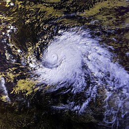
 Satellite image of Hurricane Gilma on July 25 | |
| Formed | July 21, 1994 |
|---|---|
| Dissipated | July 31, 1994 |
| Highest winds | 1-minute sustained: 160 mph (260 km/h) |
| Lowest pressure | 920 mbar (hPa); 27.17 inHg |
| Fatalities | None |
| Damage | Minimal |
| Areas affected | Johnston Atoll |
| Part of the 1994 Pacific hurricane season | |
Hurricane Gilma was one the the most intense Pacific hurricanes on record and the second of three Category 5 hurricanes during the active 1994 Pacific hurricane season.
Meteorological history

Tropical storm (39–73 mph, 63–118 km/h)
Category 1 (74–95 mph, 119–153 km/h)
Category 2 (96–110 mph, 154–177 km/h)
Category 3 (111–129 mph, 178–208 km/h)
Category 4 (130–156 mph, 209–251 km/h)
Category 5 (≥157 mph, ≥252 km/h)
Unknown
Hurricane Gilma originated from a tropical wave that moved off the coast of Africa and traversed the Atlantic Ocean during the second week of July 1994. The wave was of little note until it crossed Central America and entered the Northeastern Pacific hurricane basin on July 15-16. Convection began to increase; however, the system remained disorganized. Tracking westward, gradual development took place, leading to the Dvorak classification being initiated on July 20. Several hours later, the National Hurricane Center (NHC) designated the system as Tropical Depression Seven-E.[1] A strong ridge situated north of the depression steered the system steadily westward.[2] This movement would remain the same throughout most of the storm's existence.[1] The depression was initially hard to locate due to its large size.[3]
Following an increase in organization, the depression intensified into a tropical storm early on July 22, at which time it was named Gilma.[1] Deep convection developed around the center of circulation throughout the day and banding features became apparent on the west and south sides of the storm.[4] Only 24 hours after becoming a tropical storm, Gilma quickly intensified into a hurricane.[1] Low wind shear and warm sea surface temperatures, recorded up to 29 °C (84 °F) by a ship near the hurricane, allowed the storm to undergo rapid intensification.[5] This rate of intensification continued throughout most of July 23, resulting in the system attaining Category 4 status on the Saffir–Simpson Hurricane Scale.[1]
Forecasting, impact and records
Gilma's track was well-forecast due to the steady westward path it took for most of its life. By contrast, its intensity was often underforecast.[6] Although it was operationally forecast to become a Category 5 hurricane,[7] it was never at that intensity in real time.[8][9] The hurricane's only impact was on Johnston Atoll. That island received light rain, wind gusts to near gale force,[6] and some surf.[10] No one was killed and no damage was reported.[6]
Gilma's central pressure of 920 mbar (hPa; 27.17 inHg) is the seventh lowest ever recorded in a Pacific hurricane and the lowest ever in July.[11] Its one minute average sustained windspeed of 140 knots (260 km/h) is part of the three way tie for second highest ever in the Central Pacific Hurricane Center's area of responsibility.[12] Gilma is also the fifth known Pacific hurricane to reach Category 5 intensity on record in the Central Pacific and the second of a record three such cyclones in the 1994 Pacific hurricane season (since equaled by the 2002 season).[11] Finally, Gilma is the strongest hurricane of its season. However, Gilma's lowest pressure record may be incomplete; the 920 millibar reading of pressure is at the first of four data points when Gilma was a Category 5 hurricane;[11] that report is at the edge of a range typical of a Category 5 hurricane.[13] The remaining data points do not provide pressure levels[11] because the source provided by the Central Pacific Hurricane Center, and used by the National Hurricane Center for storm path and intensity data, does not generally provide pressure readings.[14][15]
Gilma's name was not retired after the 1994 season, and it was used again in the 2000 and 2006 seasons.[11] At a conference in 2007, Gilma's name was proposed for retirement.[16] That proposal was not accepted and the name "Gilma" remains on the list for 2012.[17]
See also
References
- ^ a b c d e Richard J. Pasch (January 20, 1995). "Hurricane Gilma Preliminary Report (Page 1)". National Hurricane Center. Retrieved January 3, 2010.
- ^ Miles B. Lawrence (July 21, 1994). "Tropical Depression Seven-E Discussion One". National Hurricane Center. Retrieved January 3, 2010.
- ^ Edward N. Rappaport (July 21, 1994). "Tropical Depression Seven-E Discussion Two". National Hurricane Center. Retrieved January 3, 2010.
- ^ Edward N. Rappaport (July 22, 1994). "Tropical Storm Gilma Discussion Six". National Hurricane Center. Retrieved January 3, 2010.
- ^ Lixion A. Avila (July 22, 1994). "Hurricane Gilma Discussion Eight". National Hurricane Center. Retrieved January 3, 2010.
- ^ a b c Richard J. Pasch (January 20, 1995). "Preliminary Report Hurricane Gilma" (GIF). National Hurricane Center. p. 2. Retrieved January 3, 2010.
- ^ Avila (July 23, 1994). "Hurricane Gilma Discussion Number 12" (GIF). National Hurricane Center. Retrieved August 18, 2008.
- ^ Sasaki (July 24, 1994). "Hurricane Gilma Marine Advisory Number 13" (GIF). National Hurricane Center. Retrieved August 18, 2008.
- ^ Rosendal (July 24, 1994). "Hurricane Gilma Discussion Number 14" (GIF). National Hurricane Center. Retrieved August 18, 2008.
- ^ "The 1994 Central Pacific Tropical Cyclone Season". Central Pacific Hurricane Center. Retrieved January 3, 2010.
- ^ a b c d e "Eastern North Pacific Tracks File 1949-2008" (plain text). National Hurricane Center. 2009. Retrieved January 3, 2010.
- ^ "Previous Tropical Systems in the Central Pacific". Central Pacific Hurricane Center. Retrieved August 18, 2008.
- ^ Chris Landsea. "Subject: D1) How are Atlantic hurricanes ranked?". National Hurricane Center. Retrieved August 18, 2008.
- ^ Richard J. Pasch (January 20, 1995). "Preliminary Report Hurricane Gilma" (GIF). National Hurricane Center. p. 3. Retrieved January 3, 2010.
- ^ Jim Gross (August 30, 1989). "Preliminary Report Hurricane Dalilia" (GIF). National Hurricane Center. p. 3. Retrieved August 28, 2008.
- ^ "61st Interdepertmental Hurricane Conference" (PDF). Office of the Federal Coordinator for Meteorology. 2007. p. 113. Retrieved August 28, 2008.
{{cite web}}: Unknown parameter|month=ignored (help) - ^ "Fact Sheet Tropical Cyclone Names" (PDF). World Meteorological Organization. July 1, 2005. p. 4. Retrieved August 26, 2008.

