Puerto Salina: Difference between revisions
Appearance
Content deleted Content added
No edit summary |
No edit summary |
||
| Line 142: | Line 142: | ||
[[Category:Beaches of Mexico]] |
[[Category:Beaches of Mexico]] |
||
[[Category:Ensenada]] |
[[Category:Ensenada]] |
||
[[Category:Ports and harbors of Baja California]] |
|||
{{BajaCalifornia-geo-stub}} |
{{BajaCalifornia-geo-stub}} |
||
Revision as of 10:24, 16 July 2011
32°03′17″N 116°53′5″W / 32.05472°N 116.88472°W
Puerto Salina | |
|---|---|
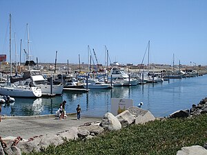
 Puerto Salina Marina boat launch | |
| Country | |
| State | Baja California |
Marina Puerto Salina is in the Mexican state of Baja California. It is located at 73 km south of Tijuana at 32° 3.28´N 116° 53.20´W. Puerto Salina is the first marina in Mexico south of the United States border on the Pacific Ocean. Puerto Salina is located next to La Salina, Baja California, 62 km (45 mi) south of San Diego Bay. The marina has more than 250 slips and can accommodate yachts as large as 100 feet in length.
Gallery


