Brok, Masovian Voivodeship: Difference between revisions
Appearance
Content deleted Content added
m robot Removing: nl:Brok (strongly connected to en:Brok (disambiguation)) |
|||
| Line 57: | Line 57: | ||
{{Masovian-geo-stub}} |
{{Masovian-geo-stub}} |
||
[[be-x-old:Брок]] |
|||
[[de:Brok]] |
[[de:Brok]] |
||
[[eo:Brok]] |
[[eo:Brok]] |
||
Revision as of 14:29, 21 September 2011
Brok | |
|---|---|
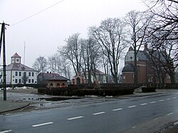
 Main Square | |
| Country | |
| Voivodeship | Masovian |
| County | Ostrów Mazowiecka |
| Gmina | Brok |
| Established | 13th century |
| Town rights | 1501 |
| Government | |
| • Mayor | Krystyna Kacpura |
| Area | |
• Total | 28.05 km2 (10.83 sq mi) |
| Population (2006) | |
• Total | 1,859 |
| • Density | 66/km2 (170/sq mi) |
| Time zone | UTC+1 (CET) |
| • Summer (DST) | UTC+2 (CEST) |
| Postal code | 07-306 |
| Area code | +48 29 |
| Car plates | WOR |
| Website | http://www.brok.pl |
Brok [brɔk] is a town in Ostrów Mazowiecka County, Masovian Voivodeship, Poland, with 1,882 inhabitants (2004).
External links
Wikimedia Commons has media related to Brok.
52°42′N 21°51′E / 52.700°N 21.850°E


