Oshima Subprefecture: Difference between revisions
Appearance
Content deleted Content added
m Update link following page move |
fix link to dab page |
||
| Line 1: | Line 1: | ||
{{dablink|This article is about the subprefecture in Hokkaidō, Japan. For the subprefecture in Kagoshima Prefecture, see [[Ōshima Subprefecture (Kagoshima)]]. For the subprefecture in Tokyo, see [[Ōshima Subprefecture (Tokyo)]]. For other uses, see [[ |
{{dablink|This article is about the subprefecture in Hokkaidō, Japan. For the subprefecture in Kagoshima Prefecture, see [[Ōshima Subprefecture (Kagoshima)]]. For the subprefecture in Tokyo, see [[Ōshima Subprefecture (Tokyo)]]. For other uses, see [[Ōshima (disambiguation)|Ōshima]].}} |
||
{{Infobox settlement |
{{Infobox settlement |
||
Revision as of 15:35, 18 May 2012
Oshima Subprefecture
渡島総合振興局 | |
|---|---|
| Oshima-sōgō-shinkō-kyoku | |
 | |
| Prefecture | Hokkaidō |
| Capital | Hakodate |
| Area | |
• Total | 3,936.32 km2 (1,519.82 sq mi) |
| Population (March 2009) | |
• Total | 449,371 |
| • Density | 110/km2 (300/sq mi) |
| Website | oshima.pref.hokkaido.lg.jp |
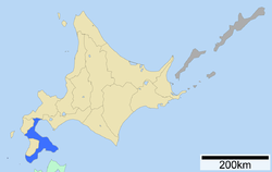
Oshima (渡島総合振興局, Oshima-sōgō-shinkō-kyoku) is a subprefecture of Hokkaidō, Japan. As of 2004 it had a population of 456,621 and an area of 3,715.38 km².
Hakodate Airport is located in the City of Hakodate.
Geography


Cities
Towns and villages by district
- Futami District
- Kameda District
- Kamiiso District
- Kayabe District
- Matsumae District
- Yamakoshi District
Mergers
External links
41°49′11″N 140°45′12″E / 41.819755°N 140.753278°E 41°25′45″N 140°06′41″E / 41.429146°N 140.111361°E(Matsumae General Branch Office)
