Roxbury Conglomerate: Difference between revisions
Moved article from Roxbury conglomerate as Roxbury Conglomerate is a formal stratigraphic unit and thus "Conglomerate" needs to be capitalized |
m →See also: added link |
||
| Line 11: | Line 11: | ||
==See also== |
==See also== |
||
*[[Hertfordshire puddingstone]] |
*[[Hertfordshire puddingstone]] |
||
+[[Puddingstone (rock)|Puddingstone]] |
|||
==Notes== |
==Notes== |
||
Revision as of 02:44, 2 April 2012

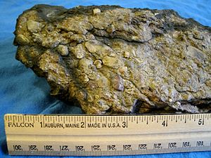
The Roxbury Conglomerate, also informally known as Roxbury puddingstone, is a name for a rock formation that forms the bedrock underlying most of Roxbury, Massachusetts, now part of the city of Boston. The bedrock formation extends well beyond the limits of Roxbury, underlying part or all of Quincy, Canton, Milton, Dorchester, Dedham, Jamaica Plain, Brighton, Brookline, Newton, Needham, and Dover. It is named for exposures in Roxbury, Boston area.[1][2]
Roxbury puddingstone is the official rock of Massachusetts. [3]
Puddingstone Park is a neighborhood park built as part of the redevelopment of a former puddingstone quarry in the Mission Hill neighborhood of Boston.
In the 19th and early 20th centuries it was frequently used to construct walls and house foundations in the Boston area; some of the stone was quarried in Brighton and Newton, but the most extensive workings were those in Roxbury[4] The American poet Oliver Wendell Holmes, wrote a poem called The Dorchester Giant in 1830, and referred to this special kind of stone, "Roxbury puddingstone", also quarried in Dorchester, which was used to build churches in the Boston area, most notably the Central Congregational Church (later called the Church of the Covenant) in Boston's Back Bay neighborhood.[5][6]: 116 [7]: 111
See also
Notes
- ^ Zen, E., R. Goldsmith, Richard N.M. Ratcliffe, P. Robinson, R.S. Stanley, N.L. Hatch, Jr., A.F. Shride, E.G.A. Weed, and D.R. Jones (1983) Bedrock geologic map of Massachusetts. Special Map, 3 sheets, scale 1:125,000. U.S. Geological Survey, Reston, Virginia.
- ^ Goldsmith, R. (1991) Stratigraphy of the Milford-Dedham zone, eastern Massachusetts; an Avalonian terrane. In N.L. Hatch, ed., pp. E1-E62, Chapter E, The bedrock geology of Massachusetts. Professional Paper. no. 1366-E. U.S. Geological Survey, Reston, Virginia.
- ^ Mass. Gen. Laws ch. 2, § 22
- ^ Massachusetts Institute of Technology Technology Quarterly, vol XVII (1904), p.166
- ^ Holmes, Oliver Wendell, Sr., The Dorchester Giant, 1830 poem.
- ^ Sammarco, Anthony Mitchell, Boston's South End, Arcadia Publishing, 1995
- ^ Drake, Samuel Adams, A book of New England legends and folk lore in prose and poetry, Boston : Little, Brown and Co., 1906
External links
- Generalized Bedrock Geology (top) and Surficial Geology (bottom) Maps of Norfolk and Suffolk Counties Massachusetts, NEsoil.com
- Geologic Unit: Roxbury, Geologic Names Lexicon, National Geological Map Database, U.S. Geological Survey, Denver, Colorado.
- MIT page on puddingstone
- City of Boston Open Space Plan 2002-2006: Maps (pdf). Page 1 shows bedrock geology, including the extent of the Roxbury Conglomerate within the Boston city limits.
