Dowarabazar Upazila: Difference between revisions
Appearance
Content deleted Content added
No edit summary |
m Reverted edits by Hussain Muhammad Iqbal (talk) to last version by Rjwilmsi |
||
| Line 64: | Line 64: | ||
|postal_code = 3070 |
|postal_code = 3070 |
||
|area_code = |
|area_code = |
||
|website = |
|website = |
||
|footnotes = |
|footnotes = |
||
}} |
}} |
||
Revision as of 07:29, 20 May 2012
Dowarabazar দোয়ারাবাজার | |
|---|---|
 | |
| Division | Sylhet Division |
| District | Sunamganj District |
| Government | |
| • MP (Sunamganj-1) | Moazzem Hossain Ratan (Awami League) |
| Area | |
• Total | 281.4 km2 (108.6 sq mi) |
| Population | |
• Total | 157,240 |
| • Density | 559/km2 (1,450/sq mi) |
| Time zone | UTC+6 (BST) |
| Postal code | 3070 |
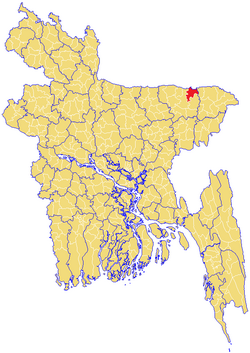
Dowarabazar (Template:Lang-bn) is an Upazila of Sunamganj District in the Division of Sylhet, Bangladesh.
Geography
Dowarabazar is located at 25°03′00″N 91°34′00″E / 25.0500°N 91.5667°E . It has 27112 units of house hold and total area 281.4 km².
Demographics
As of the 1991 Bangladesh census, Dowarabazar has a population of 157240. Males constitute are 50.74% of the population, and females 49.26%. This Upazila's eighteen up population is 76530. Dowarabazar has an average literacy rate of 15.6% (7+ years), and the national average of 32.4% literate.[1] Religions: Muslim 83.4%, Hindu 14.2%, Christian 0.5%.
Administrative
Dowarabazar has 7 Unions/Wards, 166 Mauzas/Mahallas, and 294 villages.
See also
References
- ^ "Population Census Wing, BBS". Archived from the original on 2005-03-27. Retrieved November 10, 2006.

