Punata Province: Difference between revisions
m r2.7.2) (Robot: Adding sco:Punata Province |
m r2.7.3) (Robot: Adding ru:Пуната (провинция) |
||
| Line 303: | Line 303: | ||
[[pt:Punata (província)]] |
[[pt:Punata (província)]] |
||
[[qu:Punata pruwinsya]] |
[[qu:Punata pruwinsya]] |
||
[[ru:Пуната (провинция)]] |
|||
[[sco:Punata Province]] |
[[sco:Punata Province]] |
||
[[sv:Punata (provins)]] |
[[sv:Punata (provins)]] |
||
Revision as of 16:57, 23 December 2012
Punata Province | |
|---|---|
Province | |
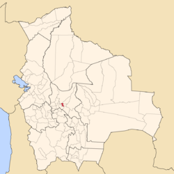
 Location of the Punata Province within Bolivia | |
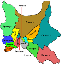
 Provinces of the Cochabamba Department | |
| Country | |
| Department | Cochabamba |
| Capital | Punata |
| Area | |
• Total | 330 sq mi (850 km2) |
| Elevation | 9,020 ft (2,750 m) |
| Population (2001) | |
• Total | 47,735 |
| • Density | 146/sq mi (56.2/km2) |
Punata is a province almost in the middle of the Cochabamba Department, Bolivia, located about 45 km south of the city of Cochabamba. Its capital is Punata. The province is limited to the north by the Chapare Province, to the north-east by the Tiraque Province, to the east by the Arani Province, to the south-east by the Mizque Province, to the south by the Esteban Arze Province and to the west by the Germán Jordán Province.
Its archaeological and historical sites are the main interest for foreign tourists.
Subdivision

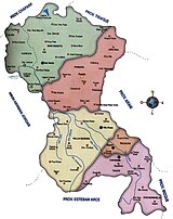
Punata Province is divided into five municipalities which are partly further subdivided into cantons.
| Section | Municipality | Seat |
|---|---|---|
| 1st | Punata Municipality | Punata |
| 2nd | Villa Rivero Municipality or Muela Municipality | Villa Rivero |
| 3rd | San Benito Municipality or Villa José Quintín Mendoza Municipality |
San Benito |
| 4th | Tacachi Municipality | Tacachi |
| 5th | Cuchumuela Municipality or Villa Gualberto Villarroel Municipality |
Cuchumuela |
The people
The people are predominantly indigenous citizens of Quechuan descent.
| Ethnic group | Punata Municipality (%) | Villa Rivero Municipality (%) | San Benito Municipality (%) | Tacachi Municipality (%) | Cuchumuela Municipality (%) |
|---|---|---|---|---|---|
| Quechua | 76.2 | 93.8 | 87.1 | 92.9 | 94.3 |
| Aymara | 0.8 | 0.1 | 0.6 | 0.1 | 0.4 |
| Guaraní, Chiquitos, Moxos | 0.1 | 0.0 | 0.1 | 0.0 | 0.2 |
| Not indigenous | 22.7 | 6.0 | 12.1 | 7.0 | 4.9 |
| Other indigenous groups | 0.2 | 0.0 | 0.1 | 0.0 | 0.2 |
Ref: obd.descentralizacion.gov.bo
Languages
The languages spoken in the Punata Province are mainly Quechua and Spanish. The following table shows the number of those belonging to the recognized group of speakers.[1]
| Language | Punata Municipality | Villa Rivero Municipality | San Benito Municipality | Tacachi Municipality | Cuchumuela Municipality |
|---|---|---|---|---|---|
| Quechua | 21,255 | 5,387 | 10,529 | 953 | 1,767 |
| Aymara | 256 | 16 | 94 | 4 | 3 |
| Guaraní | 25 | 4 | 9 | 1 | 1 |
| Another native | 22 | 7 | 6 | 0 | 1 |
| Spanish | 20,797 | 3,394 | 9,650 | 674 | 851 |
| Foreign | 148 | 14 | 48 | 3 | 1 |
| Only native | 4,232 | 2,201 | 2,450 | 350 | 968 |
| Native and Spanish | 17,096 | 3,194 | 8,105 | 603 | 801 |
| Only Spanish | 3,703 | 200 | 1,545 | 71 | 50 |
See also
- Irrigation of alluvial fans including the alluvial fan of Punata
References
- ^ obd.descentralizacion.gov.bo (Spanish)
External links
17°35′S 66°15′W / 17.583°S 66.250°W

