Ayvacık, Çanakkale: Difference between revisions
Appearance
Content deleted Content added
m r2.7.3) (Robot: Adding nn:Ayvacık i Çanakkale |
m r2.7.1) (Robot: Adding fa:آیواجیک |
||
| Line 74: | Line 74: | ||
[[de:Ayvacık (Çanakkale)]] |
[[de:Ayvacık (Çanakkale)]] |
||
[[fa:آیواجیک]] |
|||
[[fr:Ayvacık (Çanakkale)]] |
[[fr:Ayvacık (Çanakkale)]] |
||
[[sw:Ayvacık, Çanakkale]] |
[[sw:Ayvacık, Çanakkale]] |
||
Revision as of 12:24, 13 September 2012
Ayvacık | |
|---|---|
District | |
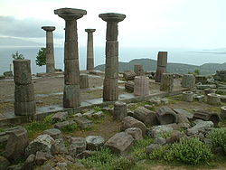
 Temple of Athena in Assos, Ayvacık | |
 Location of Ayvacık within Turkey. | |
| Country | |
| Region | Marmara |
| Province | Çanakkale |
| Government | |
| • Mayor | Mehmet Ünal Şahin (AKP) |
| Area | |
• District | 893 km2 (345 sq mi) |
| Elevation | 251 m (823 ft) |
| Population (2010) | |
• District | 30,027 |
| • Density | 34.16/km2 (88.5/sq mi) |
| • Urban | 7,457 |
| Time zone | UTC+2 (EET) |
| • Summer (DST) | UTC+3 (EEST) |
| Postal code | 17860 |
| Area code | 286 |
| Licence plate | 17 |
| Website | www.canakkaleayvacik.bel.tr |
Ayvacık is a town and district of Çanakkale Province in the Marmara region of Turkey. According to the 2007 census, population of the district is 30.027 of which 7,457 live in the town of Ayvacık.[1][2] The district covers an area of 893 km2 (345 sq mi),[3] and the town lies at an elevation of 251 m (823 ft).
See also
Notes
- ^ Statistical Institute
- ^ GeoHive. "Statistical information on Turkey's administrative units". Retrieved 2009-04-20.
- ^ Statoids. "Statistical information on districts of Turkey". Archived from the original on 19 May 2009. Retrieved 2009-04-20.
{{cite web}}: Unknown parameter|deadurl=ignored (|url-status=suggested) (help)
References
- Falling Rain Genomics, Inc. "Geographical information on Ayvacık, Turkey". Retrieved 2009-04-20.
External links
- District municipality's official website Template:Tr icon
- Road map of Ayvacık and environs
- Various images of Akliman in Ayvacık, Çanakkale
- Various images of Küçükkuyu in Ayvacık, Çanakkale
39°36′04″N 26°24′17″E / 39.60111°N 26.40472°E


