Nargiztapa: Difference between revisions
Ladytimide (talk | contribs) ←Created page with 'thumb|One of ancient gravestones on Nargiztapa hill '''Nargiztapa''' ({{lang-az|Nərgiztəpə}}) – is a locality in Mil plain...' |
Ladytimide (talk | contribs) No edit summary |
||
| Line 1: | Line 1: | ||
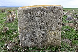
[[File:02252 nargiztepe.jpg|thumb|One of ancient gravestones on Nargiztapa hill]] |
[[File:02252 nargiztepe.jpg|thumb|250px|One of ancient gravestones on Nargiztapa hill]] |
||
'''Nargiztapa''' ({{lang-az|Nərgiztəpə}}) – is a locality in [[Mil plain]], located in [[Khojavend Rayon]] of [[Azerbaijan]], 5 km to the east from [[Khojavend (town)|Martuni]] and to the south from the Khanashenchay River’s bed<ref name="Kushnareva">[http://books.google.az/books?id=e1PNO7urjHQC&printsec=frontcover&dq=Kushnareva&hl=ru&ei=plmoTomnFojUsgbF6K3WDQ&sa=X&oi=book_result&ct=result&resnum=1&ved=0CCoQ6AEwAA#v=onepage&q=Nargiz&f=false The southern Caucasus in prehistory: stages of cultural and socioeconomic development from the eighth to the second millennium B.C.] Karinė Khristoforovna Kushnareva. UPenn Museum of Archaeology, 1997. P.136 {{ref-en}}<blockquote>Judging by the ceramics, the upper layers of Uzerlik-Tepe are contemporary with the cultural deposits in the thus far uninvestigated settlements in the Mil steppe (Geoy-Tepe, Rasul-Tepe, Nargiz-Tepe, Khan-Tepe [lessen 1965a:18]) and the basins of the Guru and Kendalan rivers (Aliyev and Ismailov 1969:48).</blockquote></ref><ref name="Академия наук СССР">Материалы и исследования по археологии СССР. — М.: Изд-во Академии наук СССР, 1965. — С. 19.<blockquote>В западной части Мильской степи, в 5 км к востоку от Мартуни и к югу от русла Xанашена, находится Наргиз-Тепе, большой холм, высотой около 8 м, занятый современным кладбищем</blockquote></ref>, where archeological objects – remains of a settlement of the [[Bronze Age]] epoch – were found out.<ref name="Kushnareva"/> |
'''Nargiztapa''' ({{lang-az|Nərgiztəpə}}) – is a locality in [[Mil plain]], located in [[Khojavend Rayon]] of [[Azerbaijan]], 5 km to the east from [[Khojavend (town)|Martuni]] and to the south from the Khanashenchay River’s bed<ref name="Kushnareva">[http://books.google.az/books?id=e1PNO7urjHQC&printsec=frontcover&dq=Kushnareva&hl=ru&ei=plmoTomnFojUsgbF6K3WDQ&sa=X&oi=book_result&ct=result&resnum=1&ved=0CCoQ6AEwAA#v=onepage&q=Nargiz&f=false The southern Caucasus in prehistory: stages of cultural and socioeconomic development from the eighth to the second millennium B.C.] Karinė Khristoforovna Kushnareva. UPenn Museum of Archaeology, 1997. P.136 {{ref-en}}<blockquote>Judging by the ceramics, the upper layers of Uzerlik-Tepe are contemporary with the cultural deposits in the thus far uninvestigated settlements in the Mil steppe (Geoy-Tepe, Rasul-Tepe, Nargiz-Tepe, Khan-Tepe [lessen 1965a:18]) and the basins of the Guru and Kendalan rivers (Aliyev and Ismailov 1969:48).</blockquote></ref><ref name="Академия наук СССР">Материалы и исследования по археологии СССР. — М.: Изд-во Академии наук СССР, 1965. — С. 19.<blockquote>В западной части Мильской степи, в 5 км к востоку от Мартуни и к югу от русла Xанашена, находится Наргиз-Тепе, большой холм, высотой около 8 м, занятый современным кладбищем</blockquote></ref>, where archeological objects – remains of a settlement of the [[Bronze Age]] epoch – were found out.<ref name="Kushnareva"/> |
||
Revision as of 09:26, 28 September 2012

Nargiztapa (Template:Lang-az) – is a locality in Mil plain, located in Khojavend Rayon of Azerbaijan, 5 km to the east from Martuni and to the south from the Khanashenchay River’s bed[1][2], where archeological objects – remains of a settlement of the Bronze Age epoch – were found out.[1]
Judging by findings of ceramics, cultural deposits of Nargiztapa locality are identical with upper layers of Uzarliktapa, a settlement of Middle Bronze Age epoch, in eastern outskirts of Agdam Rayon.[1]
References
- ^ a b c The southern Caucasus in prehistory: stages of cultural and socioeconomic development from the eighth to the second millennium B.C. Karinė Khristoforovna Kushnareva. UPenn Museum of Archaeology, 1997. P.136 Template:Ref-en
Judging by the ceramics, the upper layers of Uzerlik-Tepe are contemporary with the cultural deposits in the thus far uninvestigated settlements in the Mil steppe (Geoy-Tepe, Rasul-Tepe, Nargiz-Tepe, Khan-Tepe [lessen 1965a:18]) and the basins of the Guru and Kendalan rivers (Aliyev and Ismailov 1969:48).
- ^ Материалы и исследования по археологии СССР. — М.: Изд-во Академии наук СССР, 1965. — С. 19.
В западной части Мильской степи, в 5 км к востоку от Мартуни и к югу от русла Xанашена, находится Наргиз-Тепе, большой холм, высотой около 8 м, занятый современным кладбищем
