Brody, Lesser Poland Voivodeship: Difference between revisions
Appearance
Content deleted Content added
m Bot: Migrating 2 interwiki links, now provided by Wikidata on d:q1962586 |
photo, commons |
||
| Line 4: | Line 4: | ||
| settlement_type = Village |
| settlement_type = Village |
||
| total_type = |
| total_type = |
||
| image_skyline = Brody Kościół NMP 163.jpg |
|||
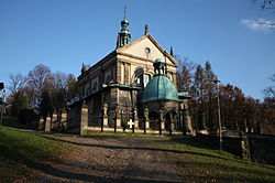
| image_caption = St. Mary church |
|||
| image_flag = |
| image_flag = |
||
| image_shield = |
| image_shield = |
||
| Line 37: | Line 39: | ||
{{reflist}} |
{{reflist}} |
||
{{commonscat|Brody, Lesser Poland Voivodeship}} |
|||
<br> |
|||
{{Gmina Kalwaria Zebrzydowska}} |
{{Gmina Kalwaria Zebrzydowska}} |
||
{{coord|49|51|57|N|19|41|51|E|region:PL_type:city|display=title}} |
{{coord|49|51|57|N|19|41|51|E|region:PL_type:city|display=title}} |
||
Revision as of 09:14, 27 February 2015
Brody | |
|---|---|
Village | |
 St. Mary church | |
| Country | |
| Voivodeship | Lesser Poland |
| County | Wadowice |
| Gmina | Kalwaria Zebrzydowska |
| Highest elevation | 340 m (1,120 ft) |
| Lowest elevation | 290 m (950 ft) |
| Population | 2,500 |
Brody [ˈbrɔdɨ] is a village in the administrative district of Gmina Kalwaria Zebrzydowska, within Wadowice County, Lesser Poland Voivodeship, in southern Poland. It lies approximately 2 kilometres (1 mi) east of Kalwaria Zebrzydowska, 15 km (9 mi) east of Wadowice, and 28 km (17 mi) south-west of the regional capital Kraków.[1]
The village has a population of 2,500.
References
Wikimedia Commons has media related to Brody, Lesser Poland Voivodeship.

