Agasage: Difference between revisions
Appearance
Content deleted Content added
m Bot: Migrating 1 interwiki links, now provided by Wikidata on d:q4691391 |
|||
| Line 1: | Line 1: | ||
{{Infobox |
{{Infobox settlement |
||
| name = Agasage |
|||
|type = village |
|||
|native_name = |
| native_name = |
||
| native_name_lang = |
|||
|other_name = |
| other_name = |
||
|taluk_names = Belgaum |
|||
| nickname = |
|||
|district = [[Belgaum]] |
|||
| settlement_type = village |
|||
|state_name = Karnataka |
|||
| |
| image_skyline = Karnataka - Belgaum.PNG |
||
| image_alt = |
|||
|parliament_const = |
|||
| ⚫ | |||
|assembly_const = |
|||
| pushpin_map = <!--India Karnataka--> |
|||
| ⚫ | |||
| pushpin_label_position = right |
|||
|skyline = Karnataka - Belgaum.PNG |
|||
| pushpin_map_alt = |
|||
| ⚫ | |||
| pushpin_map_caption = Location in Karnataka, India |
|||
|latd = |latm = |lats = |
|||
| latd = |
|||
|longd= |longm= |longs= |
|||
| latm = |
|||
|locator_position = right |
|||
| lats = |
|||
|area_total = |
|||
| latNS = N |
|||
|area_magnitude = |
|||
| longd = |
|||
|altitude = |
|||
| longm = |
|||
| ⚫ | |||
| longs = |
|||
| ⚫ | |||
| longEW = E |
|||
|population_density = |
|||
| coordinates_display = inline,title |
|||
|sex_ratio = |
|||
| subdivision_type = Country |
|||
|literacy = |
|||
| subdivision_name = {{flag|India}} |
|||
|area_telephone = |
|||
| subdivision_type1 = [[States and territories of India|State]] |
|||
| ⚫ | |||
| subdivision_name1 = [[Karnataka]] |
|||
|vehicle_code_range = |
|||
| subdivision_type2 = [[List of districts of India|District]] |
|||
|climate= |
|||
| subdivision_name2 = [[Belgaum]] |
|||
|website= |
|||
| established_title = <!-- Established --> |
|||
| established_date = |
|||
| founder = |
|||
| named_for = |
|||
| parts_type = [[Taluka]]s |
|||
| parts = Belgaum |
|||
| government_type = |
|||
| ⚫ | |||
| unit_pref = Metric |
|||
| area_footnotes = |
|||
| area_rank = |
|||
| area_total_km2 = |
|||
| elevation_footnotes = |
|||
| elevation_m = |
|||
| ⚫ | |||
| ⚫ | |||
| population_rank = |
|||
| population_density_km2 = auto |
|||
| population_demonym = |
|||
| population_footnotes = |
|||
| demographics_type1 = Languages |
|||
| demographics1_title1 = Official |
|||
| demographics1_info1 = [[Kannada]] |
|||
| timezone1 = [[Indian Standard Time|IST]] |
|||
| utc_offset1 = +5:30 |
|||
| postal_code_type = <!-- [[Postal Index Number|PIN]] --> |
|||
| ⚫ | |||
| registration_plate = |
|||
| blank1_name_sec1 = Nearest city |
|||
| blank1_info_sec1 = Belgaum |
|||
| blank2_name_sec1 = Civic agency |
|||
| blank2_info_sec1 = Village Panchayat |
|||
| website = |
|||
| footnotes = |
|||
}} |
}} |
||
Revision as of 01:46, 1 February 2014
Agasage | |
|---|---|
village | |
 Agasage is in Belgaum district | |
 | |
| Country | |
| State | Karnataka |
| District | Belgaum |
| Talukas | Belgaum |
| Government | |
| • Body | Village Panchayat |
| Languages | |
| • Official | Kannada |
| Time zone | UTC+5:30 (IST) |
| Nearest city | Belgaum |
| Civic agency | Village Panchayat |
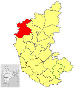
Agasage is a village in the southern state of Karnataka, India.[1][2] It is located in the Belgaum taluk of Belgaum district in Karnataka.
See also
References
- ^ "Census of India : List of Villages Alphabetical Order > Karnataka". Retrieved 2008-12-18.
{{cite web}}:|first=missing|last=(help)CS1 maint: multiple names: authors list (link) , Census Village code= 57100 - ^ "Yahoo! maps India :". Retrieved 2009-04-17. Agasage, Belgaum, Karnataka
External links
