Los Polvorines: Difference between revisions
Appearance
Content deleted Content added
pushpin map |
No edit summary |
||
| Line 1: | Line 1: | ||
{{Infobox settlement |
{{Infobox settlement |
||
|official_name = |
|official_name = BS AS |
||
|image_map = Región Metropolitana Buenos Aires.svg |
|image_map = Región Metropolitana Buenos Aires.svg |
||
|pushpin_map = Argentina Greater Buenos Aires |
|pushpin_map = Argentina Greater Buenos Aires |
||
| Line 13: | Line 13: | ||
|subdivision_name1 = [[Image:Buenos Aires province flag.gif|24px]] [[Buenos Aires Province|Buenos Aires]] |
|subdivision_name1 = [[Image:Buenos Aires province flag.gif|24px]] [[Buenos Aires Province|Buenos Aires]] |
||
|subdivision_type2 = [[Partido]] |
|subdivision_type2 = [[Partido]] |
||
|subdivision_name2 = |
|subdivision_name2 = BS AS |
||
|established_title = |
|established_title = |
||
|established_date = |
|established_date = |
||
Revision as of 13:17, 15 August 2013
BS AS | |
|---|---|
 | |
| Country | Argentina |
| Province | |
| Partido | BS AS |
| Elevation | 22 m (72 ft) |
| Population | |
• Total | 53,354 |
| CPA Base | B 1613 |
| Area code | +54 11 |
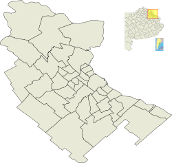
Los Polvorines is a district of the Greater Buenos Aires urban conurbation in Buenos Aires Province, Argentina. It is the county seat of the Malvinas Argentinas Partido.

External links
Municipal information: Municipal Affairs Federal Institute (IFAM), Municipal Affairs Secretariat, Ministry of Interior, Argentina. (in Spanish)
