Nagarkot: Difference between revisions
Rmv some uncited/reads like guide |
No edit summary |
||
| Line 84: | Line 84: | ||
'''Transport Details''' |
'''Transport Details''' |
||
Public buses are the main form of transportation and are incredibly cheap, incredibly uncomfortable and tediously slow. The buses to Nagarkot leave in every hour and is always packed. Buses leave almost every hour for Rs. 40 (NC). |
Public buses are the main form of transportation and are incredibly cheap, incredibly uncomfortable and tediously slow. The buses to Nagarkot leave in every hour and is always packed. Buses leave almost every hour for Rs. 40 (NC). The drive passes through the beautiful fields along Bhaktapur and later pine forest untill you get there. Or you can simply take a taxi from Kathmandu, which costs about 3,000 Rs from the tourist area of Thamel. |
||
<gallery> |
<gallery> |
||
Revision as of 10:51, 10 October 2013
This article needs additional citations for verification. (August 2013) |
Nagarkot
नगरकोट | |
|---|---|
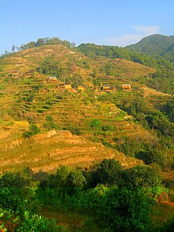
 Crops and houses on the hills of Nagarkot | |
| Country | |
| Zone | Bagmati Zone |
| District | Bhaktapur District |
| Population (1991) | |
• Total | 3,504 |
| • Religions | Hindu |
| Time zone | UTC+5:45 (Nepal Time) |
Nagarkot is a village and Village Development Committee located 32 km east of Kathmandu, Nepal in Bhaktapur District in the Bagmati Zone. At the time of the 1991 Nepal census it had a population of 3,504 and had 655 houses in it.[1] At an elevation of 2,195 meters, it is considered one of the most scenic spots in Bhaktapur District. It is renowned for its sunrise view of the Himalaya including Mount Everest as well as other snow-capped peaks of the Himalayan range of eastern Nepal. Nagarkot also offers a panoramic view of the Kathmandu Valley.[2]
Nagarkot is an international tourist destination with spectacular views of the whole Langtang range, sunrise on the mountains and sunset views.[3]
Located approx. 7000 ft (2000 m) above Sea level and 28 km from Kathmandu international airport, Nagarkot is a world famous hills station commanding breathtaking views of the majestic Himalayas, rolling hills, deep valleys, lush pine forests in a quaint rural atmosphere.
Considered as the best viewpoint spot to enjoy the magnificent sunrise and sunset with spectacular Himalayan vistas, Nagarkot commands one of the broadest views of the snow capped Himalayas in the Kathmandu valley ( 8 Himalayan ranges of Nepal out of 13 from here). The ranges include Annapurna range, Manaslu range, Ganesh himal range, Langtang range, Jugal range, Rolwaling range, Mahalangur range( Everest range) and Numbur range with splendid views of the Kathmandu valley and shivapuri national park.
Situated in a strategic location, Nagarkot was an ancient fort of the Kathmandu valley to monitor external activities of another kingdoms. Later, it became a summer retreat places for the royals before becoming popular as an international hill station.
Transport Details
Public buses are the main form of transportation and are incredibly cheap, incredibly uncomfortable and tediously slow. The buses to Nagarkot leave in every hour and is always packed. Buses leave almost every hour for Rs. 40 (NC). The drive passes through the beautiful fields along Bhaktapur and later pine forest untill you get there. Or you can simply take a taxi from Kathmandu, which costs about 3,000 Rs from the tourist area of Thamel.
-
A house and some cattle in Nagarkot
-
Village distillery
References
- ^ "Peaceful Cottage & café du mont, Nagarkot Hillstation". Blogspot. Retrieved 2008-08-26.
- ^ Lonely Planet Nepal, p. 224–225
- ^ ""nagarkot"". Flickr. Retrieved 2013-07-21.


