Deta, Romania: Difference between revisions
Appearance
Content deleted Content added
YoursBadDay (talk | contribs) Removed the Gallery, and moved the only picture it had to the infobox. |
YoursBadDay (talk | contribs) mNo edit summary |
||
| Line 1: | Line 1: | ||
{{Other uses|Deta (disambiguation)}} |
{{Other uses|Deta (disambiguation)}} |
||
{{Infobox settlement <!--more fields are available for this Infobox--See Template:Infobox Settlement--> |
{{Infobox settlement <!--more fields are available for this Infobox--See Template:Infobox Settlement--> |
||
|coordinates_display = inline,title |
|coordinates_display = inline,title |
||
|coordinates_region = RO |
|coordinates_region = RO |
||
|image_skyline= |
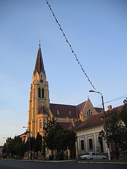
|image_skyline = File:Biserica_Deta.jpg |
||
|image_caption |
|image_caption = Roman Catholic church |
||
| ⚫ | |||
|subdivision_type = [[Countries of the world|Country]] |
|subdivision_type = [[Countries of the world|Country]] |
||
|subdivision_name = {{ROU}} |
|subdivision_name = {{ROU}} |
||
|timezone=[[Eastern European Time|EET]] |
|timezone = [[Eastern European Time|EET]] |
||
|utc_offset=+2 |
|||
|utc_offset = +2 |
|||
|timezone_DST=[[Eastern European Summer Time|EEST]] |
|timezone_DST = [[Eastern European Summer Time|EEST]] |
||
|utc_offset_DST=+3 |
|utc_offset_DST = +3 |
||
|map_caption = Location of Deta (town) |
|map_caption = Location of Deta (town) |
||
|official_name=Deta| |
|||
| |
|official_name = Deta |
||
|pushpin_label_position = <!-- the position of the pushpin label: left, right, top, bottom, none --> |
|pushpin_map = Romania |
||
|pushpin_label_position = <!-- the position of the pushpin label: left, right, top, bottom, none --> |
|||
|pushpin_map_caption =Location of Deta (town) |
|pushpin_map_caption = Location of Deta (town) |
||
|pushpin_mapsize = |
|pushpin_mapsize = |
||
|image_map= |
|image_map = |
||
|subdivision_type1=[[Counties of Romania|County]]| |
|subdivision_type1 = [[Counties of Romania|County]]| |
||
subdivision_name1= |
|subdivision_name1 = {{RO-TM}} |
||
|subdivision_type2=[[Subdivisions of Romania|Status]]| |
|subdivision_type2 = [[Subdivisions of Romania|Status]]| |
||
subdivision_name2={{Autolink|Town}} |
|subdivision_name2 = {{Autolink|Town}} |
||
| |
|settlement_type = Town |
||
| |
|leader_title = [[Mayor]] |
||
| ⚫ | |||
| ⚫ | |||
| ⚫ | |||
|settlement_type=Town|| |
|||
| ⚫ | |||
|leader_title=[[Mayor]]| |
|||
| ⚫ | |||
| ⚫ | |||
| ⚫ | |||
| ⚫ | |||
| ⚫ | |||
| ⚫ | |||
| ⚫ | |||
|latd=45|latm=24|lats=0|latNS=N|longd=21|longm=13|longs=12|longEW=E|| |
|latd=45|latm=24|lats=0|latNS=N|longd=21|longm=13|longs=12|longEW=E|| |
||
website=http://www.detatm.ro/ |
|website = http://www.detatm.ro/ |
||
}} |
}} |
||
{{Historical populations |
{{Historical populations |
||
Revision as of 10:55, 11 July 2014
Deta | |
|---|---|
Town | |
 Roman Catholic church | |
| Country | |
| County | Template:RO-TM |
| Status | Town |
| Government | |
| • Mayor | Petru Roman (Liberal-Democratic Party) |
| Area | |
• Total | 33.81 km2 (13.05 sq mi) |
| Population (2011) | |
• Total | 5,963 |
| Time zone | UTC+2 (EET) |
| • Summer (DST) | UTC+3 (EEST) |
| Website | http://www.detatm.ro/ |
| Year | Pop. | ±% |
|---|---|---|
| 1977 | 6,937 | — |
| 1992 | 7,121 | +2.7% |
| 2002 | 6,423 | −9.8% |
| 2011 | 5,963 | −7.2% |
| Source: Census data | ||
Deta is a town in Timiş County in Banat, western Romania. It administers a single village, Opatița (Opatica).
Name
In Template:Lang-de; in Template:Lang-hu; in Template:Lang-sr.
Demography
In 2002: Romanians (4,150), Hungarians (1,143), Germans (389), Serbs (329), Roma (224).
See also
External links
Wikimedia Commons has media related to Deta.


