Shekhan District: Difference between revisions
Appearance
Content deleted Content added
SerokKurdi (talk | contribs) No edit summary |
DanielRigal (talk | contribs) Reverted 1 edit by SerokKurdi (talk): Pov. (TW) |
||
| Line 13: | Line 13: | ||
|coordinates_region = |
|coordinates_region = |
||
|subdivision_type = [[List of sovereign states|Country]] |
|subdivision_type = [[List of sovereign states|Country]] |
||
|subdivision_name = |
|subdivision_name ={{flag|Iraq}} |
||
|subdivision_type1 = |
|subdivision_type1 =Regional |
||
|subdivision_name1 = [[Kurdish Regional Government|Kurdish]] |
|subdivision_name1 = [[Kurdish Regional Government|Kurdish]] |
||
|subdivision_type2 = |
|subdivision_type2 =[[Governorates of Iraq|Governorate]] |
||
|subdivision_name2 = [[Nineveh Province|Nineveh]] |
|subdivision_name2 = [[Nineveh Province|Nineveh]] |
||
|seat = [[Ain Sifni]] |
|seat = [[Ain Sifni]] |
||
| Line 39: | Line 39: | ||
}} |
}} |
||
The '''Shekhan District''' is a district in the [[Nineveh Province|Nineveh]] governorate of [[ |
The '''Shekhan District''' is a district in the [[Nineveh Province|Nineveh]] governorate of [[Iraq]] with its capital at [[Ain Sifni]].<ref name=capi>{{cite web|title=Basic information about Shekhan District|url=http://www.capiraq.org/Maps/Data3/Shekhan.pdf|website=Christian Aid Program in Iraq |accessdate=October 7, 2014|archiveurl=https://web.archive.org/web/20120425080258/http://www.capiraq.org/Maps/Data3/Shekhan.pdf|archivedate=April 25, 2012|format=PDF}}</ref> |
||
It is bordered by the [[Amadiya]] and Dahuk Districts of the [[Dohuk Governorate| |
It is bordered by the [[Amadiya]] and Dahuk Districts of the [[Dohuk Governorate|Dahuk Governorate]] to the north, the [[Akre]] district to the east, [[Al-Hamdaniya District]] to the south, and the [[Tel Kaif District]] to the west. |
||
==History== |
==History== |
||
| Line 51: | Line 51: | ||
The '''Shekhan District''' was formed on December 16, 1924.<ref name=capi/> |
The '''Shekhan District''' was formed on December 16, 1924.<ref name=capi/> |
||
After 1991 the Kurds controlled the northern part of the district. And although unified after 2003 the northern part is still under direct control of the [[Kurdish Regional Government]] |
|||
It is mainly populated by [[Ezidi]]s and [[Assyrian people|Assyrian]]s. |
|||
It is mainly populated by [[Assyrian people|Assyrian]]s, a people who retain [[Neo-Aramaic languages|Aramaic]], the language of [[Jesus]], as a spoken and written language, and [[Yazidis]]. |
|||
==References== |
==References== |
||
{{reflist}} |
{{reflist}} |
||
{{Nineveh Plains}} |
|||
{{Districts of Iraq}} |
|||
{{coord missing|Iraq}} |
|||
[[Category:Districts of Nineveh Province]] |
[[Category:Districts of Nineveh Province]] |
||
[[Category:Assyrian settlements]] |
[[Category:Assyrian settlements]] |
||
{{Iraq-geo-stub}} |
|||
Revision as of 15:54, 11 October 2014
Shekhan | |
|---|---|
 | |
 | |
| Country | |
| Regional | Kurdish |
| Governorate | Nineveh |
| founded | December 16, 1924 |
| Seat | Ain Sifni |
| Area | |
• Total | 1,259 km2 (486 sq mi) |
| Population (2003)WFP program estimation[1] | |
• Total | 90,590 |
| Time zone | UTC+3 (AST) |
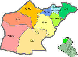
The Shekhan District is a district in the Nineveh governorate of Iraq with its capital at Ain Sifni.[1]
It is bordered by the Amadiya and Dahuk Districts of the Dahuk Governorate to the north, the Akre district to the east, Al-Hamdaniya District to the south, and the Tel Kaif District to the west.
History
| Census | Pop. | Note | %± |
|---|---|---|---|
| [1] | |||
The Shekhan District was formed on December 16, 1924.[1]
After 1991 the Kurds controlled the northern part of the district. And although unified after 2003 the northern part is still under direct control of the Kurdish Regional Government
It is mainly populated by Assyrians, a people who retain Aramaic, the language of Jesus, as a spoken and written language, and Yazidis.
References
- ^ a b c d "Basic information about Shekhan District" (PDF). Christian Aid Program in Iraq. Archived from the original (PDF) on April 25, 2012. Retrieved October 7, 2014.


