Khulna: Difference between revisions
+coor |
rearrangement of text, correcting spellings + grammar |
||
| Line 1: | Line 1: | ||
{{coor title dm|22|49|N|89|33|E|type:city}} |
{{coor title dm|22|49|N|89|33|E|type:city}} |
||
'''Khulna''' (population 1.4 million) is the third-largest city of [[Bangladesh]]. It is located |
'''Khulna''' (population 1.4 million) is the third-largest city of [[Bangladesh]]. It is located on the banks of the [[Rupsha River|Rupsha]] and [[Bhoirob River|Bhairob]] Rivers in the [[Khulna District]]. With a population of 1.4 million, it is the capital of [[Khulna Division]] and is a major industrial and commercial center. It has a seaport named Mongla on its outskirts - 60 km awat from the Khulna City. |
||
The city is 335 km southwest of Bangladesh's capital [[Dhaka]], to which it is connected by air, road, train and |
The city is 335 km southwest of Bangladesh's capital [[Dhaka]], to which it is connected by air, road, train and water transportation. The steamer fleet for this route includes the ancient ships Tern (1912), Osrich and Lepcha. |
||
==Geography== |
==Geography== |
||
Khulna district lies south of Jessore and Narail, East of Satkhira, West of Bagerhat and North of Bay of Bengal. It is part of the largest |
Khulna district lies south of [[Jessore]] and [[Narail District|Narail]], East of [[Satkhira District|Satkhira]], West of [[Bagerhat]] and North of [[Bay of Bengal]]. It is part of the largest delta of the world. Khulna is mainly a plain land. Southern part of the delta is [[Sundarban]], the world's largest mangrove forest. The city of Khulna is on the northern part of the district. It is mainly expansion of trade centers by the rivers Rupsha and Bhairob. |
||
It is divided into several parts. The commercial areas near the river, residential area and new expansions under the KDA project. |
It is divided into several parts. The commercial areas near the river, residential area and new expansions under the KDA project. |
||
Revision as of 13:54, 21 July 2006
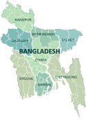
22°49′N 89°33′E / 22.817°N 89.550°E Khulna (population 1.4 million) is the third-largest city of Bangladesh. It is located on the banks of the Rupsha and Bhairob Rivers in the Khulna District. With a population of 1.4 million, it is the capital of Khulna Division and is a major industrial and commercial center. It has a seaport named Mongla on its outskirts - 60 km awat from the Khulna City.
The city is 335 km southwest of Bangladesh's capital Dhaka, to which it is connected by air, road, train and water transportation. The steamer fleet for this route includes the ancient ships Tern (1912), Osrich and Lepcha.
Geography
Khulna district lies south of Jessore and Narail, East of Satkhira, West of Bagerhat and North of Bay of Bengal. It is part of the largest delta of the world. Khulna is mainly a plain land. Southern part of the delta is Sundarban, the world's largest mangrove forest. The city of Khulna is on the northern part of the district. It is mainly expansion of trade centers by the rivers Rupsha and Bhairob.
It is divided into several parts. The commercial areas near the river, residential area and new expansions under the KDA project.
History
This section needs expansion. You can help by adding to it. |
Economy
This section needs expansion. You can help by adding to it. |

