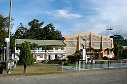
Duero, Bohol: Difference between revisions
Appearance
Content deleted Content added
m Reverted edits by Mary McAllen (talk) to last version by Frietjes |
update census and election; add table |
||
| Line 1: | Line 1: | ||
{{Infobox settlement |
{{Infobox settlement |
||
| name = Duero |
| name = Duero |
||
| settlement_type = |
| settlement_type = {{PH wikidata|settlement_type}} |
||
| image_skyline = |
| image_skyline = {{PH wikidata|image_skyline}} |
||
| image_caption = |
| image_caption = {{PH wikidata|image_caption}} |
||
| image_flag = {{PH wikidata|image_flag}} |
| image_flag = {{PH wikidata|image_flag}} |
||
| flag_size = 120x80px |
| flag_size = 120x80px |
||
| Line 9: | Line 9: | ||
| image_seal = {{PH wikidata|image_seal}} |
| image_seal = {{PH wikidata|image_seal}} |
||
| seal_size = 100x80px |
| seal_size = 100x80px |
||
| nickname = |
|||
| motto = {{PH wikidata|motto}} |
| motto = {{PH wikidata|motto}} |
||
| image_map = {{PH wikidata|image_map}} |
| image_map = {{PH wikidata|image_map}} |
||
| Line 19: | Line 18: | ||
| coordinates_display = it |
| coordinates_display = it |
||
| coordinates_format = dms |
| coordinates_format = dms |
||
| coordinates_region = PH |
| coordinates_region = {{PH wikidata|coordinates_region}} |
||
| subdivision_type = [[List of sovereign states|Country]] |
| subdivision_type = [[List of sovereign states|Country]] |
||
| subdivision_name = {{PH wikidata|country}} |
| subdivision_name = {{PH wikidata|country}} |
||
| Line 33: | Line 32: | ||
| parts = 21 (see § [[#Barangays|Barangays]]) |
| parts = 21 (see § [[#Barangays|Barangays]]) |
||
| government_type = {{PH wikidata|government_type}} |
| government_type = {{PH wikidata|government_type}} |
||
| government_footnotes = <ref |
| government_footnotes = {{thinsp}}<ref>{{DILG detail}}</ref> |
||
| leader_party = [[Liberal Party (Philippines)|LP]] |
| leader_party = [[Liberal Party (Philippines)|LP]] |
||
| leader_title = {{PH wikidata|leader_title}} |
| leader_title = {{PH wikidata|leader_title}} |
||
| leader_name = Conrada Amparo |
| leader_name = Conrada Amparo |
||
| leader_title1 = {{PH wikidata|vicemayor_title}} |
| leader_title1 = {{PH wikidata|vicemayor_title}} |
||
| leader_name1 = |
| leader_name1 = Emma Bajade |
||
| leader_title2 = {{PH wikidata|council_title}} |
| leader_title2 = {{PH wikidata|council_title}} |
||
| leader_name2 = {{PH Town Council |
| leader_name2 = {{PH Town Council |
||
| |
| |
||
| Gillian Achacoso |
| Gillian Achacoso |
||
| M |
| M{{sup|a}} Rowena Sajonia |
||
| Polienoto Bernadas |
| Polienoto Bernadas |
||
| Elizabeth Espinosa |
| Elizabeth Espinosa |
||
| Line 50: | Line 49: | ||
| Hernes Bajao |
| Hernes Bajao |
||
}} |
}} |
||
| area_total_km2 = {{PH wikidata|area}} |
|||
| area_footnotes = <ref name=boholgov>{{cite web |url=http://www.bohol.gov.ph/index.php??=duero |title=Municipality of Duero |accessdate ={{date|30 jan 2015}}}}</ref> |
|||
| |
| area_footnotes = {{PSGC detail|nscb}} |
||
| elevation_footnotes = |
| elevation_footnotes = |
||
| elevation_m = |
| elevation_m = |
||
| |
| population_total = {{PH wikidata|population_total}} |
||
| |
| population_as_of = {{PH wikidata|population_as_of}} |
||
| population_density_km2 = auto |
|||
| population_as_of = {{PH wikidata|population_as_of}} |
|||
| population_blank1_title = {{PH wikidata|electorate_title}} |
|||
| population_density_km2 = auto |
|||
| population_blank1 = {{PH wikidata|electorate}} |
|||
| population_blank1_title = Languages |
|||
| population_blank2_title = Language |
|||
| population_blank1 = [[Boholano dialect|Boholano (Binisaya)]] |
|||
| population_blank2 = {{PH wikidata|language}} |
|||
| population_demonym = |
|||
| population_note = |
| population_note = |
||
| |
| population_footnotes = {{PH census|current|07}} |
||
| timezone = [[Philippine Standard Time|PST]] |
| timezone = [[Philippine Standard Time|PST]] |
||
| utc_offset = +8 |
| utc_offset = +8 |
||
| Line 68: | Line 69: | ||
| area_code_type = {{areacodestyle}} |
| area_code_type = {{areacodestyle}} |
||
| area_code = {{PH wikidata|area_code}} |
| area_code = {{PH wikidata|area_code}} |
||
| blank_name_sec1 = |
| blank_name_sec1 = {{PH wikidata|income_class_title}} |
||
| blank_info_sec1 = |
| blank_info_sec1 = {{PH wikidata|income_class_ordinal}} |
||
| blank1_name_sec1 = {{PSGCstyle}} |
| blank1_name_sec1 = {{PSGCstyle}} |
||
| blank1_info_sec1 = {{PSGC detail}} |
| blank1_info_sec1 = {{PSGC detail}} |
||
| blank2_name_sec1 = [[ICAO]] |
|||
| blank2_info_sec1 = {{PH wikidata|icao}} |
|||
| blank3_name_sec1 = [[IATA]] |
|||
| blank3_info_sec1 = {{PH wikidata|iata}} |
|||
| blank2_name_sec2 = Patron Saint <!-- Patron saint --> |
|||
| blank2_info_sec2 = {{PH wikidata|patron_saint}} |
|||
| website = {{PH wikidata|website}} |
| website = {{PH wikidata|website}} |
||
| footnotes = |
| footnotes = |
||
}} |
}} |
||
'''Duero''' is a |
'''Duero''' is a [[{{PH plural|{{PH wikidata|settlement_text}}}} of the Philippines#Income classification|{{PH wikidata|income_class_text}} {{PH wikidata|settlement_text|prefix=cc}}]] in the province of {{PH wikidata|province}}, [[Philippines]]. According to the {{PH wikidata|population_as_of}}, it has a population of {{PH wikidata|population_total}}.{{PH census|current}} {{PH electorate|{{PH wikidata|electorate}}}} It may have been named after the [[Douro]] (Duero) in the [[Iberian peninsula]]. |
||
Roman Catholicism was introduced to the town in 1860 by a Spanish priest. Duero was established as a municipality two years later, and a convent was constructed in 1868.<ref name=boholgov/> |
Roman Catholicism was introduced to the town in 1860 by a Spanish priest. Duero was established as a municipality two years later, and a convent was constructed in 1868.<ref name=boholgov/> |
||
==Barangays== |
==Barangays== |
||
Duero is divided into 21 [[barangay]]s: |
|||
Duero comprises 21 barangays: |
|||
{{div col|3}} |
|||
{| class="wikitable sortable" style="background-color:white;margin:0 auto;font-size:95%;" |
|||
* Alejawan |
|||
! style="border-bottom:none;" | {{PSGCstyle|no}} |
|||
* Angilan |
|||
! style="text-align:left;border-bottom:none;" | Name |
|||
* Anibongan |
|||
! style="border-bottom:none;" colspan=2 | Population |
|||
* Bangwalog |
|||
! style="border-bottom:none;" | {{PSGC rubric}} |
|||
* Cansuhay |
|||
|- |
|||
* Danao |
|||
! style="border-top:none;" | |
|||
* Duay |
|||
! style="border-top:none;" | |
|||
* Guinsularan |
|||
! style="border-width:0 0 thin thin;" | {{small|(2015)}}{{PH census|2015|07}} |
|||
* Itum |
|||
! style="border-width:0 thin thin 0;" | {{small|(2010)}}{{PH census|2010|07}} |
|||
* Langkis |
|||
! style="border-top:none;" | |
|||
* Lobogon |
|||
|- |
|||
* Madua Norte |
|||
| | 071221001 |
|||
* Madua Sur |
|||
| style="text-align:left" | Alejawan |
|||
* Mambool |
|||
| style="text-align:right;padding-left:1em;padding-right:1em;" | 773 |
|||
* Mawi |
|||
| style="text-align:right;padding-left:1em;padding-right:1em;" | 801 |
|||
* Payao |
|||
| style="text-align:right;padding-left:1em;padding-right:1em;" | {{PAGR|2010.3315| 801|2015.5836| 773}} |
|||
* San Antonio (Poblacion) |
|||
|- |
|||
* San Isidro |
|||
| | 071221002 |
|||
* San Pedro |
|||
| style="text-align:left" | Angilan |
|||
* Imelda |
|||
| style="text-align:right;padding-left:1em;padding-right:1em;" | 514 |
|||
* Taytay |
|||
| style="text-align:right;padding-left:1em;padding-right:1em;" | 540 |
|||
{{div col end}} |
|||
| style="text-align:right;padding-left:1em;padding-right:1em;" | {{PAGR|2010.3315| 540|2015.5836| 514}} |
|||
|- |
|||
| | 071221003 |
|||
| style="text-align:left" | Anibongan |
|||
| style="text-align:right;padding-left:1em;padding-right:1em;" | 479 |
|||
| style="text-align:right;padding-left:1em;padding-right:1em;" | 540 |
|||
| style="text-align:right;padding-left:1em;padding-right:1em;" | {{PAGR|2010.3315| 540|2015.5836| 479}} |
|||
|- |
|||
| | 071221004 |
|||
| style="text-align:left" | Bangwalog |
|||
| style="text-align:right;padding-left:1em;padding-right:1em;" | 1,358 |
|||
| style="text-align:right;padding-left:1em;padding-right:1em;" | 1,340 |
|||
| style="text-align:right;padding-left:1em;padding-right:1em;" | {{PAGR|2010.3315|1340|2015.5836|1358}} |
|||
|- |
|||
| | 071221005 |
|||
| style="text-align:left" | Cansuhay |
|||
| style="text-align:right;padding-left:1em;padding-right:1em;" | 789 |
|||
| style="text-align:right;padding-left:1em;padding-right:1em;" | 735 |
|||
| style="text-align:right;padding-left:1em;padding-right:1em;" | {{PAGR|2010.3315| 735|2015.5836| 789}} |
|||
|- |
|||
| | 071221006 |
|||
| style="text-align:left" | Danao |
|||
| style="text-align:right;padding-left:1em;padding-right:1em;" | 646 |
|||
| style="text-align:right;padding-left:1em;padding-right:1em;" | 688 |
|||
| style="text-align:right;padding-left:1em;padding-right:1em;" | {{PAGR|2010.3315| 688|2015.5836| 646}} |
|||
|- |
|||
| | 071221007 |
|||
| style="text-align:left" | Duay |
|||
| style="text-align:right;padding-left:1em;padding-right:1em;" | 482 |
|||
| style="text-align:right;padding-left:1em;padding-right:1em;" | 390 |
|||
| style="text-align:right;padding-left:1em;padding-right:1em;" | {{PAGR|2010.3315| 390|2015.5836| 482}} |
|||
|- |
|||
| | 071221008 |
|||
| style="text-align:left" | Guinsularan |
|||
| style="text-align:right;padding-left:1em;padding-right:1em;" | 1,689 |
|||
| style="text-align:right;padding-left:1em;padding-right:1em;" | 1,736 |
|||
| style="text-align:right;padding-left:1em;padding-right:1em;" | {{PAGR|2010.3315|1736|2015.5836|1689}} |
|||
|- |
|||
| | 071221016 |
|||
| style="text-align:left" | Imelda |
|||
| style="text-align:right;padding-left:1em;padding-right:1em;" | 603 |
|||
| style="text-align:right;padding-left:1em;padding-right:1em;" | 615 |
|||
| style="text-align:right;padding-left:1em;padding-right:1em;" | {{PAGR|2010.3315| 615|2015.5836| 603}} |
|||
|- |
|||
| | 071221009 |
|||
| style="text-align:left" | Itum |
|||
| style="text-align:right;padding-left:1em;padding-right:1em;" | 1,135 |
|||
| style="text-align:right;padding-left:1em;padding-right:1em;" | 1,139 |
|||
| style="text-align:right;padding-left:1em;padding-right:1em;" | {{PAGR|2010.3315|1139|2015.5836|1135}} |
|||
|- |
|||
| | 071221010 |
|||
| style="text-align:left" | Langkis |
|||
| style="text-align:right;padding-left:1em;padding-right:1em;" | 980 |
|||
| style="text-align:right;padding-left:1em;padding-right:1em;" | 1,002 |
|||
| style="text-align:right;padding-left:1em;padding-right:1em;" | {{PAGR|2010.3315|1002|2015.5836| 980}} |
|||
|- |
|||
| | 071221011 |
|||
| style="text-align:left" | Lobogon |
|||
| style="text-align:right;padding-left:1em;padding-right:1em;" | 1,338 |
|||
| style="text-align:right;padding-left:1em;padding-right:1em;" | 1,329 |
|||
| style="text-align:right;padding-left:1em;padding-right:1em;" | {{PAGR|2010.3315|1329|2015.5836|1338}} |
|||
|- |
|||
| | 071221012 |
|||
| style="text-align:left" | Madua Norte |
|||
| style="text-align:right;padding-left:1em;padding-right:1em;" | 515 |
|||
| style="text-align:right;padding-left:1em;padding-right:1em;" | 475 |
|||
| style="text-align:right;padding-left:1em;padding-right:1em;" | {{PAGR|2010.3315| 475|2015.5836| 515}} |
|||
|- |
|||
| | 071221013 |
|||
| style="text-align:left" | Madua Sur |
|||
| style="text-align:right;padding-left:1em;padding-right:1em;" | 731 |
|||
| style="text-align:right;padding-left:1em;padding-right:1em;" | 699 |
|||
| style="text-align:right;padding-left:1em;padding-right:1em;" | {{PAGR|2010.3315| 699|2015.5836| 731}} |
|||
|- |
|||
| | 071221014 |
|||
| style="text-align:left" | Mambool |
|||
| style="text-align:right;padding-left:1em;padding-right:1em;" | 607 |
|||
| style="text-align:right;padding-left:1em;padding-right:1em;" | 556 |
|||
| style="text-align:right;padding-left:1em;padding-right:1em;" | {{PAGR|2010.3315| 556|2015.5836| 607}} |
|||
|- |
|||
| | 071221015 |
|||
| style="text-align:left" | Mawi |
|||
| style="text-align:right;padding-left:1em;padding-right:1em;" | 523 |
|||
| style="text-align:right;padding-left:1em;padding-right:1em;" | 518 |
|||
| style="text-align:right;padding-left:1em;padding-right:1em;" | {{PAGR|2010.3315| 518|2015.5836| 523}} |
|||
|- |
|||
| | 071221016 |
|||
| style="text-align:left" | Payao |
|||
| style="text-align:right;padding-left:1em;padding-right:1em;" | 639 |
|||
| style="text-align:right;padding-left:1em;padding-right:1em;" | 598 |
|||
| style="text-align:right;padding-left:1em;padding-right:1em;" | {{PAGR|2010.3315| 598|2015.5836| 639}} |
|||
|- |
|||
| | 071221017 |
|||
| style="text-align:left" | San Antonio (Pob.) |
|||
| style="text-align:right;padding-left:1em;padding-right:1em;" | 1,181 |
|||
| style="text-align:right;padding-left:1em;padding-right:1em;" | 1,211 |
|||
| style="text-align:right;padding-left:1em;padding-right:1em;" | {{PAGR|2010.3315|1211|2015.5836|1181}} |
|||
|- |
|||
| | 071221014 |
|||
| style="text-align:left" | San Isidro |
|||
| style="text-align:right;padding-left:1em;padding-right:1em;" | 816 |
|||
| style="text-align:right;padding-left:1em;padding-right:1em;" | 809 |
|||
| style="text-align:right;padding-left:1em;padding-right:1em;" | {{PAGR|2010.3315| 809|2015.5836| 816}} |
|||
|- |
|||
| | 071221015 |
|||
| style="text-align:left" | San Pedro |
|||
| style="text-align:right;padding-left:1em;padding-right:1em;" | 1,467 |
|||
| style="text-align:right;padding-left:1em;padding-right:1em;" | 1,334 |
|||
| style="text-align:right;padding-left:1em;padding-right:1em;" | {{PAGR|2010.3315|1334|2015.5836|1467}} |
|||
|- |
|||
| | 071221015 |
|||
| style="text-align:left" | Taytay |
|||
| style="text-align:right;padding-left:1em;padding-right:1em;" | 611 |
|||
| style="text-align:right;padding-left:1em;padding-right:1em;" | 525 |
|||
| style="text-align:right;padding-left:1em;padding-right:1em;" | {{PAGR|2010.3315| 525|2015.5836| 611}} |
|||
|-class=sortbottom style="border-top:solid thin black;border-bottom:double medium black;background-color:#f8f8f8;" |
|||
| style="border-right-style:none;" | |
|||
| style="text-align:left;font-variant:small-caps;font-weight:bold;letter-spacing:0.2em;border-left-style:none;" | TOTAL |
|||
| style="text-align:right;padding-right:1em;" | 17,876 |
|||
| style="text-align:right;padding-right:1em;" | 17,580 |
|||
| style="text-align:right;padding-right:1em;" | {{PAGR|2010.3315|17580|2015.5836|17876}} |
|||
|} |
|||
==Demographics== |
==Demographics== |
||
{{Philippine Census |align=none |
|||
{{Philippine Census |align=left |
|||
| cols = 2 |
|||
| width = 12em |
|||
| title = Population census of Duero |
| title = Population census of Duero |
||
| 1990 = 14242 |
| 1990 = 14242 |
||
| Line 115: | Line 246: | ||
| 2007 = 17254 |
| 2007 = 17254 |
||
| 2010 = 17580 |
| 2010 = 17580 |
||
| 2015 = 17876 |
|||
| footnote = Source: National Statistics Office{{PH census|2010}}{{PH census|2007}} |
|||
| footnote = Source: Philippine Statistics Office{{PH census|2015|07}}{{PH census|2010|07}}{{PH census|2007}} |
|||
}} |
}} |
||
{{PH electorate|{{PH wikidata|electorate}}|long}} |
|||
{{clear left}} |
|||
==Gallery== |
|||
<gallery mode=packed heights=136px> |
|||
==Images== |
|||
<gallery mode=packed-hover heights=136px> |
|||
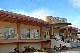
Duero Bohol 3.JPG|Duero town hall |
Duero Bohol 3.JPG|Duero town hall |
||
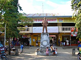
Duero Bohol 1.JPG|Public market |
Duero Bohol 1.JPG|Public market |
||
| Line 125: | Line 259: | ||
</gallery> |
</gallery> |
||
==References== |
|||
{{Reflist}} |
|||
{{portal|Bohol}} |
{{portal|Bohol}} |
||
==References== |
|||
{{Reflist|30em|refs= |
|||
<ref name=boholgov>{{cite web |url=http://www.bohol.gov.ph/index.php??=duero |title=Municipality of Duero |accessdate ={{date|30 jan 2015}}}}</ref> |
|||
}} |
|||
==External links== |
==External links== |
||
{{Commons category}} |
|||
{{Commons category|{{PH wikidata|commons}}|Duero|position=left}} |
|||
* [http://www.bohol.gov.ph/duero.html Municipality of Duero] |
* [http://www.bohol.gov.ph/duero.html Municipality of Duero] |
||
| Line 145: | Line 284: | ||
[[Category:Municipalities of Bohol]] |
[[Category:Municipalities of Bohol]] |
||
[[Category:1862 establishments in the Philippines]] |
[[Category:1862 establishments in the Philippines]] |
||
{{CVisayas-geo-stub}} |
{{CVisayas-geo-stub}} |
||
Revision as of 08:26, 9 July 2016
Duero | |
|---|---|
 Duero | |
 Map of Bohol with Duero highlighted | |
| Country | Philippines |
| Region | Central Visayas (Region VII) |
| Province | Bohol |
| District | 3rd district of Bohol |
| Founded | 1862 |
| Barangay | 21 (see § Barangays) |
| Government | |
| • Type | Sangguniang Bayan |
| • mayor of Duero[*] | Conrada Amparo (LP) |
| • Vice mayor of Duero | Emma Bajade |
| • Municipal Council | Members |
| Area | |
• Total | 97.30 km2 (37.57 sq mi) |
| Population (2020 census)[3] | |
• Total | 18,861 |
| • Density | 190/km2 (500/sq mi) |
| • Voter (2022)[4] | 14,109 |
| • Language | Boholano dialect Cebuano Eskayan Tagalog |
| Time zone | UTC+8 (PST) |
| ZIP code | 6309 |
| IDD : area code | +63 (0)38 |
| Income class | 4th class |
| PSGC | 071221000 |
Duero is a [[Template:PH plural of the Philippines#Income classification|4th municipal income class municipality]] in the province of Bohol, Philippines. According to the 2020 census, it has a population of 18,861.[3] Template:PH electorate It may have been named after the Douro (Duero) in the Iberian peninsula.
Roman Catholicism was introduced to the town in 1860 by a Spanish priest. Duero was established as a municipality two years later, and a convent was constructed in 1868.[5]
Barangays
Duero comprises 21 barangays:
| PSGC | Name | Population | ±% p.a. | |
|---|---|---|---|---|
| (2015)[6] | (2010)[7] | |||
| 071221001 | Alejawan | 773 | 801 | −0.68% |
| 071221002 | Angilan | 514 | 540 | −0.94% |
| 071221003 | Anibongan | 479 | 540 | −2.26% |
| 071221004 | Bangwalog | 1,358 | 1,340 | 0.25% |
| 071221005 | Cansuhay | 789 | 735 | 1.36% |
| 071221006 | Danao | 646 | 688 | −1.19% |
| 071221007 | Duay | 482 | 390 | 4.12% |
| 071221008 | Guinsularan | 1,689 | 1,736 | −0.52% |
| 071221016 | Imelda | 603 | 615 | −0.37% |
| 071221009 | Itum | 1,135 | 1,139 | −0.07% |
| 071221010 | Langkis | 980 | 1,002 | −0.42% |
| 071221011 | Lobogon | 1,338 | 1,329 | 0.13% |
| 071221012 | Madua Norte | 515 | 475 | 1.55% |
| 071221013 | Madua Sur | 731 | 699 | 0.86% |
| 071221014 | Mambool | 607 | 556 | 1.68% |
| 071221015 | Mawi | 523 | 518 | 0.18% |
| 071221016 | Payao | 639 | 598 | 1.27% |
| 071221017 | San Antonio (Pob.) | 1,181 | 1,211 | −0.48% |
| 071221014 | San Isidro | 816 | 809 | 0.16% |
| 071221015 | San Pedro | 1,467 | 1,334 | 1.83% |
| 071221015 | Taytay | 611 | 525 | 2.93% |
| TOTAL | 17,876 | 17,580 | 0.32% | |
Demographics
|
| ||||||||||||||||||||||||
| Source: Philippine Statistics Office[6][7][8] | |||||||||||||||||||||||||
Gallery
-
Duero town hall
-
Public market
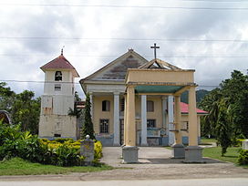
-
Church
References
- ^ Municipality of Duero | (DILG)
- ^ "Municipal: Duero, Bohol". PSGC Interactive. Quezon City, Philippines: Philippine Statistics Authority. Retrieved 8 January 2016.
- ^ a b Census of Population (2020). "Region VII (Central Visayas)". Total Population by Province, City, Municipality and Barangay. Philippine Statistics Authority. Retrieved 8 July 2021.
- ^ "Number of Registered Voters by Sex : 2019 National and Local Elections" (PDF). Commission on Elections. 2019.
- ^ "Municipality of Duero". Retrieved 30 January 2015.
- ^ a b Census of Population (2015). "Region VII (Central Visayas)". Total Population by Province, City, Municipality and Barangay. Philippine Statistics Authority. Retrieved 20 June 2016.
- ^ a b Census of Population and Housing (2010). "Region VII (Central Visayas)" (PDF). Total Population by Province, City, Municipality and Barangay. National Statistics Office. Retrieved 29 June 2016.
- ^ Censuses of Population (1903–2007). "Region VII (Central Visayas)". Table 1. Population Enumerated in Various Censuses by Province/Highly Urbanized City: 1903 to 2007. National Statistics Office.
External links
Wikimedia Commons has media related to Duero.


