Baitsi District: Difference between revisions
Appearance
Content deleted Content added
m fixed typo |
JJMC89 bot (talk | contribs) Migrate {{Infobox settlement}} coordinates parameters to {{Coord}}, see Wikipedia:Coordinates in infoboxes |
||
| Line 13: | Line 13: | ||
| mapsize = |
| mapsize = |
||
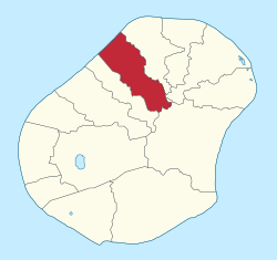
| map_caption = Baitsi District within Nauru |
| map_caption = Baitsi District within Nauru |
||
| coordinates_display = inline,title |
|||
| coordinates_region = |
|||
| subdivision_type = Country |
| subdivision_type = Country |
||
| subdivision_name = {{NRU}} |
| subdivision_name = {{NRU}} |
||
| Line 41: | Line 39: | ||
| pushpin_map_caption1 = |
| pushpin_map_caption1 = |
||
| pushpin_mapsize = |
| pushpin_mapsize = |
||
| coordinates = {{coord|0|30|25|S|166|55|54|E|display=inline,title}} |
|||
| latd=0 |latm=30 |lats=25 |latNS=S |
|||
| longd=166 |longm=55 |longs=54 |longEW=E |
|||
| timezone = ([[UTC+12:00|UTC+12]]) |
| timezone = ([[UTC+12:00|UTC+12]]) |
||
| utc_offset = |
| utc_offset = |
||
Revision as of 15:45, 9 February 2017
Baitsi | |
|---|---|
 Baitsi District within Nauru | |
| Coordinates: 0°30′25″S 166°55′54″E / 0.50694°S 166.93167°E | |
| Country | |
| Constituency | Ubenide |
| Area | |
• Total | 1.2 km2 (0.5 sq mi) |
| Elevation | 25 m (82 ft) |
| Population (2011) | |
• Total | 513 |
| Time zone | (UTC+12) |
| Area code | +674 |
Baitsi, formerly known as Baiti and previously as Beidi, is a district in the Pacific nation of Nauru. It belongs to Ubenide Constituency.
Geography
Location
The district is located in the northwest of the island. It covers an area of 1.2 km².
Former villages
| Former villages |
|---|
| Adrurior |
| Aeonun |
| Anakawida |
| Anut |
| Ataneu |
| Atirabu |
| Baiti (village) |
| Deradae |
| Ibedwe |
| Imangengen |
| Imaraga |
| Mangadab |
| Mereren |
| Umaruru |
| Yatabang |
See also
References
External links
![]() Media related to Baitsi at Wikimedia Commons
Media related to Baitsi at Wikimedia Commons

