Boulindieng: Difference between revisions
Appearance
Content deleted Content added
Add map |
JJMC89 bot (talk | contribs) Migrate {{Infobox settlement}} coordinates parameters to {{Coord}}, see Wikipedia:Coordinates in infoboxes |
||
| Line 10: | Line 10: | ||
|pushpin_label_position = right |
|pushpin_label_position = right |
||
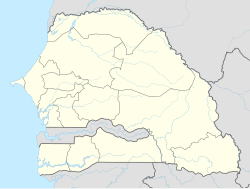
|pushpin_map_caption = Location in Senegal |
|pushpin_map_caption = Location in Senegal |
||
|coordinates_display = inline,title |
|||
|coordinates_region = SN |
|||
|subdivision_type = [[List of sovereign states|Country]] |
|subdivision_type = [[List of sovereign states|Country]] |
||
|subdivision_name = {{flag|Senegal}} |
|subdivision_name = {{flag|Senegal}} |
||
| Line 33: | Line 31: | ||
|timezone = [[Greenwich Mean Time|GMT]] |
|timezone = [[Greenwich Mean Time|GMT]] |
||
|utc_offset = +0 |
|utc_offset = +0 |
||
|coordinates = {{coord|12|41|5|N|16|8|58|W|region:SN|display=inline,title}} |
|||
|latd=12|latm=41|lats=5|latNS=N |
|||
|longd=16 |longm=8|longs=58|longEW=W |
|||
|elevation_footnotes = |
|elevation_footnotes = |
||
|elevation_m = |
|elevation_m = |
||
Revision as of 01:34, 14 March 2017
Boulindieng | |
|---|---|
| Coordinates: 12°41′5″N 16°8′58″W / 12.68472°N 16.14944°W | |
| Country | |
| Region | Ziguinchor |
| Department | Bignona |
| Arrondissement | Tenghory |
| Commune | Coubalan |
| Population (2002) | |
• Total | 152 |
| Time zone | UTC+0 (GMT) |
Boulindieng is a settlement in the Bignona Department of Ziguinchor Region of Senegal. It had a population of 502 in 2002. [1]
References
- ^ "Localité de Boulindien". PEPAM. Retrieved 17 November 2016.

