Warwick, Quebec: Difference between revisions
Appearance
Content deleted Content added
Updated the poutine history and the cheese festival info, provided references #1Lib1Ref |
JJMC89 bot (talk | contribs) Migrate {{Infobox settlement}} coordinates parameters to {{Coord}}, see Wikipedia:Coordinates in infoboxes |
||
| Line 11: | Line 11: | ||
|pushpin_label = |
|pushpin_label = |
||
|pushpin_map_caption = Location in southern Quebec. |
|pushpin_map_caption = Location in southern Quebec. |
||
| |
| coordinates = {{coord|45|57|N|71|59|W|region:CA-QC|display=inline,title}} |
||
| longd = 71 | longm = 59 | longs = | longEW = W |
|||
| coor_pinpoint = |
| coor_pinpoint = |
||
| coordinates_region = CA-QC |
|||
| coordinates_display = inline,title |
|||
| coordinates_footnotes = <ref name="toponymie"/> |
| coordinates_footnotes = <ref name="toponymie"/> |
||
| subdivision_type = Country |
| subdivision_type = Country |
||
Revision as of 20:39, 6 March 2017
Warwick | |
|---|---|
 | |
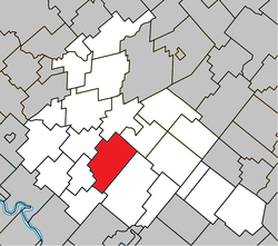
 Location within Arthabaska RCM | |
| Coordinates: 45°57′N 71°59′W / 45.950°N 71.983°W[1] | |
| Country | |
| Province | |
| Region | Centre-du-Québec |
| RCM | Arthabaska |
| Constituted | March 15, 2000 |
| Government | |
| • Mayor | Diego Scalzo |
| • Federal riding | Richmond—Arthabaska |
| • Prov. riding | Drummond–Bois-Francs |
| Area | |
• Total | 110.40 km2 (42.63 sq mi) |
| • Land | 109.97 km2 (42.46 sq mi) |
| Population | |
• Total | 4,766 |
| • Density | 43.3/km2 (112/sq mi) |
| • Pop 2006-2011 | |
| Time zone | UTC−5 (EST) |
| • Summer (DST) | UTC−4 (EDT) |
| Postal code(s) | |
| Area code | 819 |
| Highways | |
| Website | www |
Warwick is a small town north east of Montreal, located in Arthabaska county, Quebec, Canada. The town was incorporated in 1861 and named after a city of the same name in England.
Up until 2014 the town hosted Quebec's annual summer cheese festival, which showcases many of the locally produced artisanal cheeses. In 2014 the festival was moved to Victoriaville.[4] Warwick is also claimed to be one possible birthplace of the poutine (fries with gravy and cheese curds).[5]
It is an industrial centre, with factories for agricultural machinery, washing-machines, overalls, cheese-boxes, and doors.
Warwick is located on Route 116.
References
- ^ "Banque de noms de lieux du Québec: Reference number 66652". toponymie.gouv.qc.ca (in French). Commission de toponymie du Québec.
- ^ a b "Répertoire des municipalités: Geographic code 39077". www.mamh.gouv.qc.ca (in French). Ministère des Affaires municipales et de l'Habitation.
- ^ a b "Warwick, Quebec (Code 2439077) Census Profile". 2011 census. Government of Canada - Statistics Canada.
- ^ "Le Festival de fromages de Warwick déménagerait à Victoriaville… | La Terre de Chez Nous". La Terre de Chez Nous (in French). 2014-09-25. Retrieved 2017-01-23.
- ^ Adam, L. G. (2014). "OFF DUTY --- adventure & travel -- in search of: Quebec's baddest poutine --- for the richest, runniest, gut-busting-est combo of fries, cheese and gravy, head to its canadian birthplace". Wall Street Journal. May 03.
External links
 Media related to Warwick (Québec) at Wikimedia Commons
- City of Warwick Template:Fr icon
- Warwick cheese festival webpage Template:Fr icon


