Mediterranean Sea: Difference between revisions
m No such word as "Asori" in Greek... |
|||
| Line 26: | Line 26: | ||
* [[French language|French]]: ''Mer Méditerranée'' |
* [[French language|French]]: ''Mer Méditerranée'' |
||
* [[German language|German]]: ''das Mittelmeer'' ("Middle sea") |
* [[German language|German]]: ''das Mittelmeer'' ("Middle sea") |
||
* [[Greek language|Greek]]: ''Mesogeios Thalassa'' (Μεσόγειος Θάλασσα |
* [[Greek language|Greek]]: ''Mesogeios Thalassa'' (Μεσόγειος Θάλασσα) |
||
* [[Hebrew language|Hebrew]]: ''ha-Yam ha-Tikhon'' (הים התיכון) ["Middle Sea"] |
* [[Hebrew language|Hebrew]]: ''ha-Yam ha-Tikhon'' (הים התיכון) ["Middle Sea"] |
||
* [[Icelandic language|Icelandic]]: ''Miðjarðarhaf'' |
* [[Icelandic language|Icelandic]]: ''Miðjarðarhaf'' |
||
Revision as of 13:43, 22 September 2006
- For the oceanographic term and other mediterranean seas, see Mediterranean sea (oceanography).

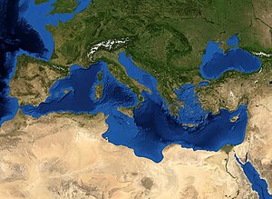
The Mediterranean Sea is a part of the Atlantic Ocean almost completely enclosed by land: on the north by Europe, on the south by Africa, and on the east by Asia. It covers an approximate area of 2.5 million km² (965 000 mi²), but its connection to the Atlantic (the Strait of Gibraltar) is only 14 km (9 mi) wide. In oceanography, it is sometimes called the Eurafrican Mediterranean Sea or the European Mediterranean Sea, to distinguish it from mediterranean seas elsewhere.
It was a superhighway of transport in ancient times, allowing for trade and cultural exchange between emergent peoples of the region — the Mesopotamian, Egyptian, Semitic, Persian, Phoenician, Carthaginian, Greek and Roman cultures. The history of the Mediterranean is important in understanding the origin and development of Western Civilization.
Name
The term Mediterranean derives from the Latin mediterraneus, 'inland' (medius, 'middle' + terra, 'land, earth'), in Greek "mesogeios".
The Mediterranean Sea has been known by a number of alternative names throughout human history. It was, for example, commonly called Mare Nostrum (Latin, Our Sea), and occasionally Mare Internum by the Romans. (Sallust, Jug. 17). In the Old Testament, on the west coast of the Holy Land, and therefore behind a person facing the east, it is called the "Hinder Sea", sometimes translated as "Western Sea", (Deut. xi. 24; Joel, ii. 20), and also the "Sea of the Philistines" (Exod. xxii. 81), because that people occupied a large portion of its shores near the Israelites. Mostly, however, it was the "Great Sea" (Num. xxxiv. 6, 7; Josh. i. 4, ix. 1, xv. 47; Ezek. xlvii. 10, 15, 20), or simply "The Sea" (1 Kings, v. 9; comp. 1 Macc. xiv. 34. xv. 11). In Hebrew, it is called "ha-Yam ha-Tikhon" (הַיָּם הַתִּיכוֹן), "the middle sea", a literal adaptation of the German equivalent Mittelmeer. In Turkish, it is Akdeniz, "the white sea". In Arabic, it is Al-Baħr Al-Abyad Al-Muttawasit (البحر الأبيض المتوسط), "the middle white sea".
Most languages spoken around the Mediterranean have a name for the sea, often a translation of either "middle sea" or "white sea", including:
|
|
Currently, "The Med" is a common British English contraction for the Mediterranean Sea and its surrounding regions when employed in informal speech.
History
Geography and Climate

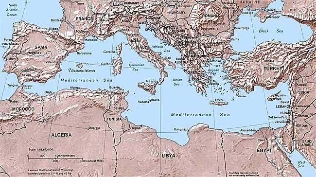
The Mediterranean Sea is connected to the Atlantic Ocean by the Strait of Gibraltar on the west and to the Sea of Marmara and Black Sea, by the Dardanelles and the Bosporus respectively, on the east. The Sea of Marmara is often considered a part of the Mediterranean Sea, whereas the Black Sea is generally not. The man-made Suez Canal in the south-east connects the Mediterranean Sea with the Red Sea.
Large islands in the Mediterranean include Cyprus, Crete, Euboea, Rhodes, Lesbos, Chios, Kefalonia and Corfu in the eastern Mediterranean; Sardinia, Corsica, Sicily, and Malta in the central Mediterranean; and Ibiza, Majorca and Minorca (the Balearic Islands) in the western Mediterranean.
The Mediterranean climate is generally one of wet winters and hot, dry summers. Special crops of the region are olives, grapes, oranges, tangerines, and cork.
Oceanography
Being nearly landlocked strongly affects the Mediterranean Sea's properties; for instance, tides are very limited as a result of the narrow connection with the ocean.
Evaporation greatly exceeds precipitation and river runoff in the Mediterranean, a fact that is central to the entire circulation of the basin.[1] Evaporation is especially high in its eastern half, causing the water level to decrease and salinity to increase eastward.[2] This pressure gradient pushes relatively cool, low-salinity water from the Atlantic across the basin; it warms and becomes saltier as it travels east, then sinks in the region of the Levant and circulates westward, to spill over the Strait of Gibraltar.[3] Thus, seawater flow is eastward in the Strait's surface waters, and westward below; once in the open ocean, this chemically-distinct Mediterranean Intermediate Water can persist thousands of kilometers away from its source.[4]
Bordering countries

22 modern states have a coastline on the Mediterranean Sea. They are:
- Europe (from west to east): Spain, France, Monaco, Italy, the island state of Malta, Slovenia, Croatia, Bosnia and Herzegovina, Montenegro, Albania, Greece, Turkey, and the island Republic of Cyprus.
- Asia (from north to south): Turkey, Syria, Lebanon and Israel.
- Africa (from east to west): Egypt, Libya, Tunisia, Algeria and Morocco.
Several other entities not recognized by all as states also border the Mediterranean Sea (from west to east):
- The Crown colony of Gibraltar.
- The Spanish exclaves of Ceuta and Melilla and nearby islands.
- The autonomous monastic state of Mount Athos.
- The sovereign base area of Akrotiri and Dhekelia
- The Gaza Strip, which current plans foresee being part of an independent State of Palestine.
Portugal, Armenia, Jordan, and the Vatican City State, although they do not border the sea, are usually considered Mediterranean countries in a wider sense due to their Mediterranean climate, fauna and flora, and their cultural affinity with other Mediterranean countries.
Subdivisions

The Mediterranean Sea is sub-divided into a number of smaller seas, each with their own designation (from west to east):
- the Alboran Sea, between Spain and Morocco,
- the Balearic Sea, between mainland Spain and its Balearic Islands,
- the Ligurian Sea between Corsica and Liguria (Italy),
- the Tyrrhenian Sea enclosed by Sardinia, Italian peninsula and Sicily,
- the Adriatic Sea between the Italian peninsula and the Croatian, Bosnian and the coast of Montenegro
- the Ionian Sea between Italy, Greece, and Albania,
- the Aegean Sea between Greece and Turkey, with
- the Thracian Sea in its north,
- the Myrtoan Sea between the Cyclades and the Peloponnesos,
- the Sea of Crete north of Crete, and
- the Libyan Sea south of Crete, between the island and Libya
- the Sea of Marmara between the Aegean and Black Seas.
- the Cilician Sea between Turkey and Cyprus
Many of these smaller seas feature in local myth and folklore and derive their names from these associations. In addition to the seas, a number of gulfs and straits are also recognised:
- the Gulf of Corinth, an enclosed sea between the Ionian Sea and the Corinth Canal
- the Saronic Gulf, the gulf of Athens, between the Corinth Canal and the Mirtoan Sea
- the Thermaic Gulf, the gulf of Thessaloniki, located in the northern Greek region of Macedonia
- the Gulf of Lion, south of France
- the Strait of Messina, between Sicily and the toe of Italy
- the Gulf of Taranto, southern Italy,
- the Gulf of Haifa, between Haifa and Akko, Israel
- the Gulf of Sidra, between Tunisia and Cyrenaica (eastern Libya)
- the Strait of Sicily, between Sicily and Tunisia
- the Corsica Channel, between Corsica and Italy
- the Strait of Bonifacio, between Sardinia and Corsica
- the Gulf of Iskenderun, between Iskenderun and Adana (Turkey).
- the Gulf of Antalya, between west and east shores of Antalya (Turkey).
Geology
The geology of the Mediterranean is complex, involving the break-up and then collision of the African and Eurasian plates, and the Messinian Salinity Crisis in the late Miocene when the Mediterranean dried up.
The Mediterranean Sea has an average depth of 1,500 m and the deepest recorded point is 5267 meters (about 3.27 miles) in the Calypso Deep in the Ionian Sea. The coastline extends for 46,000 km. A shallow submarine ridge (the Strait of Sicily) between the island of Sicily and the coast of Tunisia divides the sea in two main subregions (which in turn are divided into subdivisions), the Western Mediterranean and the Eastern Mediterranean. The Western Mediterranean covers an area of about 0.85 million km² and the Eastern Mediterranean about 1.65 million km².
In the last few centuries, mankind has done much to alter Mediterranean geology. Structures have been built all along the coastlines, exacerbating and rerouting erosional patterns. Many pollution-producing boats travel the sea that unbalance the natural chemical ratios of the region. Beaches have been mismanaged, and the overuse of the sea's natural and marine resources continues to be a problem. This misuse speeds along and/or confounds natural processes. The actual geography has also been altered by the building of dams and canals.
The Mediterranean was once thought to be the remnant of the Tethys Ocean. It is now known to be a structurally younger ocean basin known as Neotethys. Neotethys formed during the Late Triassic and Early Jurassic rifting of the African and Eurasian plates.
Ecology
As a result of the drying of the sea during the Messinian Salinity Crisis, the marine biota of the Mediterranean are derived primarily from the Atlantic Ocean. The North Atlantic is considerably colder and more nutrient-rich than the Mediterranean, and the marine life of the Mediterranean has had to adapt to its differing conditions in the five million years since the basin was reflooded.
The opening of the Suez Canal in 1869 created the first salt-water passage between the Mediterranean and Red seas. The Red Sea is higher than the Eastern Mediterranean, so the canal serves as a salt-water river that pours Red Sea water into the Mediterranean. The Bitter Lakes, which are hypersaline natural lakes that form part of the canal, blocked the migration of Red Sea species into the Mediterranean for many decades, but as the salinity of the lakes gradually equalized with that of the Red Sea, the barrier to migration was removed, and plants and animals from the Red Sea have begun to colonize the eastern Mediterranean. The Red Sea is generally saltier and more nutrient-poor than the Atlantic, so the Red Sea species have advantages over Atlantic species in the salty and nutrient-poor Eastern Mediterranean. The construction of the Aswan High Dam across the Nile River in the 1960s reduced the inflow of freshwater and nutrient-rich silt from the Nile into the eastern Mediterranean, which has made conditions there even more like the Red Sea. This species exchange is known as the Lessepsian Migration, after Ferdinand de Lesseps, the engineer who oversaw the canal's construction.
See also
- Seaports of Valencia (Spain)
- Mediterranean Basin
- Mediterranean forests, woodlands, and shrub
- Mediterranean sea (oceanography term)
- List of islands in the Mediterranean
- Familial Mediterranean fever
- History of the Mediterranean
- Holy League (Mediterranean)
- Inland Sea, which is sometimes named after the Japanese Mediterranean Sea
- Suez Canal
