McDonalds Mill, Virginia: Difference between revisions
Appearance
Content deleted Content added
JJMC89 bot (talk | contribs) Migrate {{Infobox settlement}} coordinates parameters to {{Coord}}, see Wikipedia:Coordinates in infoboxes |
→top: Can now zoom in and out with one click |
||
| Line 13: | Line 13: | ||
<!-- Maps --> |
<!-- Maps --> |
||
| ⚫ | |||
|image_map = |
|||
|pushpin_label = McDonalds{{nbsp}}Mill |
|||
|mapsize = |
|||
|map_caption = |
|||
| ⚫ | |||
|pushpin_label_position = none<!-- the position of the pushpin label: left, right, top, bottom, none --> |
|||
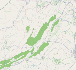
|pushpin_map_caption = Location within the Commonwealth of Virginia |
|||
<!-- Location --> |
<!-- Location --> |
||
Revision as of 16:52, 7 May 2017
McDonalds Mill, Virginia | |
|---|---|
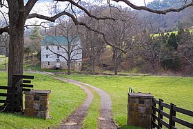
 Historic McDonalds Mill | |
| Coordinates: 37°18′00″N 80°16′32″W / 37.30000°N 80.27556°W | |
| Country | United States |
| State | Virginia |
| County | Montgomery |
McDonalds Mill[1] is an unincorporated community in the northeastern section of Montgomery County, Virginia. Located approximately 10 miles east of Blacksburg, Virginia along State Route 785, McDonalds Mill lies at the floor of the Catawba Valley and is bound on the south by Paris Mountain and to the north by Gallion Ridge.
History
A post office called McDonalds Mills operated from 1847 until 1913.[2] George McDonald operated a mill there, hence the name.[3]
References
- ^ U.S. Geological Survey Geographic Names Information System: McDonalds Mill, Virginia
- ^ "Montgomery County". Jim Forte Postal History. Retrieved 28 September 2014.
- ^ Tennis, Joe (2004). Southwest Virginia Crossroads: An Almanac of Place Names and Places to See. The Overmountain Press. p. 140. ISBN 978-1-57072-256-1.


