Ternopil Raion: Difference between revisions
Appearance
Content deleted Content added
No edit summary |
|||
| Line 1: | Line 1: | ||
{{Infobox |
{{Infobox settlement |
||
<!-- See Template:Infobox settlement for additional fields and descriptions --> |
|||
| name=Ternopil Raion |
| name = Ternopil Raion |
||
| ⚫ | |||
| |
| native_name = Тернопільський район |
||
| native_name_lang = uk<!-- ISO 639-2 code e.g. "fr" for French. --> |
|||
| country=[[Ukraine]] |
|||
| settlement_type = [[Raions of Ukraine|Raion]] |
|||
| ⚫ | |||
| image_skyline = |
|||
| ⚫ | |||
| image_alt = |
|||
| ⚫ | |||
| image_caption = |
|||
| date_created=1966 |
|||
| ⚫ | |||
| population=67231 |
|||
| flag_alt = Flag of Ternopil Raion |
|||
| area=749 |
|||
| ⚫ | |||
| density=81.19 |
|||
| shield_alt = Coat of arms of Ternopil Raion |
|||
| ⚫ | |||
| ⚫ | |||
| ⚫ | |||
| mapsize = |
|||
| phone_code= +380-352 |
|||
| map_alt = |
|||
| postal_index= |
|||
| map_caption = |
|||
| administrative_center=[[Ternopil]] |
|||
| pushpin_map = |
|||
| cities= |
|||
| pushpin_label_position = |
|||
| urban-type_settlements=2 |
|||
| pushpin_map_alt = |
|||
| villages=56 |
|||
| pushpin_map_caption = |
|||
| ⚫ | |||
| coordinates = |
|||
| governor= |
|||
| coor_pinpoint = |
|||
| coordinates_footnotes = |
|||
| subdivision_type = Country |
|||
| subdivision_name = {{UKR}} |
|||
| subdivision_type1 = [[Oblasts of Ukraine|Region]] |
|||
| ⚫ | |||
| parts_type = Subdivisions |
|||
| parts_style = coll |
|||
| p1 = — city councils |
|||
| p2 = — settlement councils |
|||
| p3 = — rural councils<br/><br/> |
|||
| p4 = '''Number of localities:'''<br/> — cities |
|||
| p5 = {{nowrap| — urban-type settlements}} |
|||
| p6 = 56 — villages |
|||
| p7 = — rural settlements |
|||
| established_title = Established |
|||
| established_date = 1966 |
|||
| seat_type = [[Administrative centre|Admin. center]] |
|||
| seat = [[Ternopil]] |
|||
| government_footnotes = |
|||
| leader_party = |
|||
| leader_title = Governor |
|||
| leader_name = |
|||
| leader_title1 = Chairman |
|||
| leader_name1 = |
|||
| unit_pref = Metric<!-- or US or UK --> |
|||
| area_footnotes = |
|||
| area_total_km2 = 749 |
|||
| elevation_footnotes = |
|||
| elevation_m = |
|||
| population_footnotes = |
|||
| population_total = 67231 |
|||
| population_as_of = |
|||
| population_density_km2 = auto |
|||
| timezone1 = [[Eastern European Time|EET]] |
|||
| utc_offset1 = +02:00 |
|||
| timezone1_DST = [[Eastern European Summer Time|EEST]] |
|||
| utc_offset1_DST = +03:00 |
|||
| ⚫ | |||
| ⚫ | |||
| area_code_type = [[Telephone numbers in Ukraine|Area code]] |
|||
| area_code = +380-352 |
|||
| iso_code = |
|||
| ⚫ | |||
| footnotes = |
|||
}} |
}} |
||
Revision as of 10:29, 2 June 2019
Ternopil Raion
Тернопільський район | |
|---|---|
 | |
| Country | |
| Region | Ternopil Oblast |
| Established | 1966 |
| Admin. center | Ternopil |
| Subdivisions | List
|
| Area | |
• Total | 749 km2 (289 sq mi) |
| Population | |
• Total | 67,231 |
| • Density | 90/km2 (230/sq mi) |
| Time zone | UTC+02:00 (EET) |
| • Summer (DST) | UTC+03:00 (EEST) |
| Postal index | 47701—47745 |
| Area code | +380-352 |
| Website | http://www.ternoregion.com.ua/ Ternopil Raion |
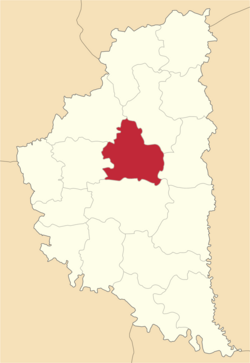
The Ternopil Raion (Template:Lang-uk) is a raion in Ternopil Oblast in western Ukraine. Its administrative center is Ternopil. It has a population of 60, 810.
Settlements
- Urban-type Settlement
- Villages
- Anhelivka
- Baikivtsi
- Bavoriv
- Bila
- Biloskirka
- Butsniv
- Cherneliv-Rus'kyi
- Chystyliv
- Domamorych
- Dovzhanka
- Drahanivka
- Dubivtsi
- Dychkiv
- Hai-Hrechyns'ki
- Hai-Shevchenkivs'ki
- Hrabovets'
- Ihrovytsya
- Ivachiv Dolishnii
- Ivachiv Horishnii
- Khatky
- Kostyantynivka
- Kozivka
- Kyp'yachka
- Lozova
- Luchka
- Malyi Khodachkiv
- Marianivka
- Myrolyubivka
- Myshkovychi
- Nastasiv
- Ostriv
- Petrykiv
- Pidhorodne
- Plotycha
- Pochapyntsi
- Proshova
- Romanivka
- Seredynky
- Shlyakhtyntsi
- Skomorokhy
- Smolyanka
- Smykivtsi
- Soborne
- Stehnykivtsi
- Stupky
- Teofilivka
- Tovstoluh
- Velyka Luka
- Velyki Hai
- Velykyi Hlybochok
- Yosypivka
- Zaboiky
- Zastav'je
- Zastinka
See also
External links


