Borden Tunnel: Difference between revisions
Appearance
Content deleted Content added
category refine |
category refine |
||
| Line 45: | Line 45: | ||
{{Maryland hiking trails}} |
{{Maryland hiking trails}} |
||
[[Category: |
[[Category:Tunnels in Allegany County, Maryland]] |
||
[[Category:Railroad tunnels in Maryland]] |
[[Category:Railroad tunnels in Maryland]] |
||
[[Category:Rail trails in Maryland]] |
[[Category:Rail trails in Maryland]] |
||
Revision as of 23:00, 18 November 2017
 Borden Tunnel | |
| Overview | |
|---|---|
| Location | Allegany County, near Frostburg, Maryland |
| Coordinates | 39°41′19″N 78°55′08″W / 39.68861°N 78.91889°W |
| Status | Restored, converted to rail trail |
| System | Western Maryland Railway (defunct) |
| Operation | |
| Opened | 1911 |
| Closed | 1975 (rail line abandoned) |
| Technical | |
| Length | 957.5 ft (291.8 m) |
| No. of tracks | Double |
| Track gauge | 1,435 mm (4 ft 8+1⁄2 in) standard gauge |
| Highest elevation | 2036 ft (621 m) |
| Grade | 1.7% |
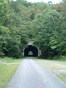
The Borden Tunnel is a 957-foot long, formerly abandoned, railway tunnel located about 2.5 miles (4 km) north of Frostburg, Maryland. Unlighted, it is now part of the Great Allegheny Passage rail trail.[1][2]
The Western Maryland Railway built the tunnel in 1911 for its Connellsville Subdivision. The rail line was abandoned in 1975.[3]
References
- ^ Allegheny Highlands Trail of Maryland, Cumberland, MD. "History Along the Trail: Borden Tunnel."[permanent dead link] Accessed 2010-01-13.
- ^ Downing, Bob (2008-07-14). "Great Allegheny Passage follows 150-mile rail-trail through mountain scenery". Pittsburgh Post-Gazette. Retrieved May 30, 2009.
- ^ Cook, Roger; Zimmermann, Karl (1992). The Western Maryland Railway: Fireballs and Black Diamonds (2nd ed.). Laurys Station, Pennsylvania: Garrigues House. p. 283. ISBN 0-9620844-4-1.
- Western Maryland Railway Co., Baltimore, MD (1955). "Track Chart: Connellsville to Cumberland."
External links
- Borden Tunnel map and photos - WMWestSub.com
