McDonalds Mill, Virginia: Difference between revisions
Appearance
Content deleted Content added
m →top: clean up, replaced: Political divisions of the United States|State → U.S. state|State, List of countries| → List of sovereign states|, United States → United States using AWB |
→References: add authority control |
||
| Line 64: | Line 64: | ||
{{Montgomery County, Virginia}} |
{{Montgomery County, Virginia}} |
||
{{authority control}} |
|||
{{DEFAULTSORT:Mcdonalds Mill, Virginia}} |
{{DEFAULTSORT:Mcdonalds Mill, Virginia}} |
||
Revision as of 03:08, 15 February 2020
McDonalds Mill, Virginia | |
|---|---|
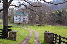
 Historic McDonalds Mill | |
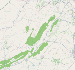
| Coordinates: 37°18′00″N 80°16′32″W / 37.30000°N 80.27556°W | |
| Country | United States |
| State | Virginia |
| County | Montgomery |
McDonalds Mill[1] is an unincorporated community in the northeastern section of Montgomery County, Virginia. Located approximately 10 miles east of Blacksburg, Virginia along State Route 785, McDonalds Mill lies at the floor of the Catawba Valley and is bound on the south by Paris Mountain and to the north by Gallion Ridge.
History
A post office called McDonalds Mills operated from 1847 until 1913.[2] George McDonald operated a mill there, hence the name.[3]
References
- ^ U.S. Geological Survey Geographic Names Information System: McDonalds Mill, Virginia
- ^ "Montgomery County". Jim Forte Postal History. Retrieved 28 September 2014.
- ^ Tennis, Joe (2004). Southwest Virginia Crossroads: An Almanac of Place Names and Places to See. The Overmountain Press. p. 140. ISBN 978-1-57072-256-1.


