Waun Camddwr: Difference between revisions
Appearance
Content deleted Content added
No edit summary |
m Date formats |
||
| Line 1: | Line 1: | ||
{{Use dmy dates|date=September 2019}} |
|||
{{Infobox mountain |
{{Infobox mountain |
||
| name = Waun Camddwr |
| name = Waun Camddwr |
||
| Line 15: | Line 16: | ||
}} |
}} |
||
'''Waun Camddwr''' is a top of [[Aran Fawddwy]] in the south of the [[Snowdonia National Park]] in [[Gwynedd]], [[Wales]]. It is the highest point on a wide boggy area between the summits of [[Aran Fawddwy]] and [[Glasgwm]]. It was surveyed after the first Nuttall list was compiled, and found to have just enough prominence to be included. The summit is a rocky outcrop amid an area of heather, long grass and peat bog. [[Gwaun y Llwyni]] rises to the south of the summit.<ref>Nuttall, John & Anne (1999). The Mountains of England & Wales - Volume 1: Wales (2nd edition ed.). Milnthorpe, Cumbria: Cicerone. {{ISBN|1-85284-304-7}}.</ref> |
'''Waun Camddwr''' is a top of [[Aran Fawddwy]] in the south of the [[Snowdonia National Park]] in [[Gwynedd]], [[Wales]]. It is the highest point on a wide boggy area between the summits of [[Aran Fawddwy]] and [[Glasgwm]]. It was surveyed after the first Nuttall list was compiled, and found to have just enough prominence to be included. The summit is a rocky outcrop amid an area of heather, long grass and peat bog. [[Gwaun y Llwyni]] rises to the south of the summit.<ref>Nuttall, John & Anne (1999). The Mountains of England & Wales - Volume 1: Wales (2nd edition ed.). Milnthorpe, Cumbria: Cicerone. {{ISBN|1-85284-304-7}}.</ref> |
||
==References== |
==References== |
||
{{reflist}} |
{{reflist}} |
||
==External links== |
==External links== |
||
* [https://www.geograph.org.uk/search.php?i=2797533 www.geograph.co.uk : photos of Aran Fawddwy and surrounding area] |
* [https://www.geograph.org.uk/search.php?i=2797533 www.geograph.co.uk : photos of Aran Fawddwy and surrounding area] |
||
| Line 30: | Line 31: | ||
[[Category:Mountains and hills of Snowdonia]] |
[[Category:Mountains and hills of Snowdonia]] |
||
[[Category:Nuttalls]] |
[[Category:Nuttalls]] |
||
{{Gwynedd-geo-stub}} |
{{Gwynedd-geo-stub}} |
||
Revision as of 18:32, 3 September 2019
| Waun Camddwr | |
|---|---|
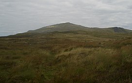
 The summit of Waun Camddwr with Aran Fawddwy (behind) | |
| Highest point | |
| Elevation | 622 m (2,041 ft) |
| Prominence | 16 m (52 ft) |
| Parent peak | Aran Fawddwy |
| Listing | Nuttall |
| Naming | |
| Language of name | Welsh |
| Geography | |
 | |
| Location | Gwynedd, Wales |
| Parent range | Snowdonia |
| OS grid | SH847205 |
| Topo map | OS Landranger 124 |
Waun Camddwr is a top of Aran Fawddwy in the south of the Snowdonia National Park in Gwynedd, Wales. It is the highest point on a wide boggy area between the summits of Aran Fawddwy and Glasgwm. It was surveyed after the first Nuttall list was compiled, and found to have just enough prominence to be included. The summit is a rocky outcrop amid an area of heather, long grass and peat bog. Gwaun y Llwyni rises to the south of the summit.[1]
References
- ^ Nuttall, John & Anne (1999). The Mountains of England & Wales - Volume 1: Wales (2nd edition ed.). Milnthorpe, Cumbria: Cicerone. ISBN 1-85284-304-7.
External links
52°47′16.35″N 3°41′18.10″W / 52.7878750°N 3.6883611°W
