Waikanae River: Difference between revisions
m category refine, sort sequence |
interlink Tags: Mobile edit Mobile app edit iOS app edit |
||
| Line 7: | Line 7: | ||
The river drains the western flanks of the [[Tararua Range]]s around [[Reikorangi]] and the [[Akatarawa Valley]], then passes to the south of the town of [[Waikanae]] before entering the [[Tasman Sea]] at Waikanae Beach. Tributaries include the [[Maungakotukutuku Stream]], [[Ngatiawa River]], and [[Reikorangi Stream]]. The [[estuary]] of the river is a significant reserve providing shelter and habitat for local and migratory seabirds. It also provides a major recreational location, both for residents and tourists. |
The river drains the western flanks of the [[Tararua Range]]s around [[Reikorangi]] and the [[Akatarawa Valley]], then passes to the south of the town of [[Waikanae]] before entering the [[Tasman Sea]] at Waikanae Beach. Tributaries include the [[Maungakotukutuku Stream]], [[Ngatiawa River]], and [[Reikorangi Stream]]. The [[estuary]] of the river is a significant reserve providing shelter and habitat for local and migratory seabirds. It also provides a major recreational location, both for residents and tourists. |
||
Water up to a maximum amount is taken out of the river as water supply for [[Waikanae]] and [[Paraparaumu]]. This sometimes leads to water restrictions if the river runs low, however in January 2005 the river burst its banks after heavy rain. The river has good water quality and high aquatic biodiversity, but there are occasional blooms of toxic cyanobacteria after prolonged periods of low flow during hot, dry weather. |
Water up to a maximum amount is taken out of the river as water supply for [[Waikanae]] and [[Paraparaumu]]. This sometimes leads to water restrictions if the river runs low, however in January 2005 the river burst its banks after heavy rain. The river has good water quality and high aquatic biodiversity, but there are occasional blooms of toxic [[cyanobacteria]] after prolonged periods of low flow during hot, dry weather. |
||
==External links== |
==External links== |
||
Revision as of 23:50, 26 July 2020
This article needs additional citations for verification. (March 2007) |


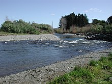
Waikanae River is located on the Kapiti Coast in the North Island of New Zealand.
The river drains the western flanks of the Tararua Ranges around Reikorangi and the Akatarawa Valley, then passes to the south of the town of Waikanae before entering the Tasman Sea at Waikanae Beach. Tributaries include the Maungakotukutuku Stream, Ngatiawa River, and Reikorangi Stream. The estuary of the river is a significant reserve providing shelter and habitat for local and migratory seabirds. It also provides a major recreational location, both for residents and tourists.
Water up to a maximum amount is taken out of the river as water supply for Waikanae and Paraparaumu. This sometimes leads to water restrictions if the river runs low, however in January 2005 the river burst its banks after heavy rain. The river has good water quality and high aquatic biodiversity, but there are occasional blooms of toxic cyanobacteria after prolonged periods of low flow during hot, dry weather.
External links
- Photo of the Waikanae River from the Cyclopaedia of New Zealand c1897
- Photo of the Waikanae rail and road bridges and express train on bridge c1939
- Photo of the Waikanae rail and road bridges and express train leaving bridge c1938
- South bank of Waikanae River with strata identified
- 132793862 Waikanae River on OpenStreetMap
40°53′S 175°00′E / 40.883°S 175.000°E
