Fort Wayne metropolitan area, Indiana: Difference between revisions
GreenC bot (talk | contribs) Rescued 1 archive link; Move 1 url. Wayback Medic 2.5 |
GreenC bot (talk | contribs) Move 2 urls. Wayback Medic 2.5 |
||
| Line 1: | Line 1: | ||
The '''Fort Wayne, IN Metropolitan Statistical Area''', or '''Northeast Indiana''', is a federally designated [[United States metropolitan area|metropolitan area]] consisting of three counties in northeastern [[Indiana]] ([[Allen County, Indiana|Allen]], [[Wells County, Indiana|Wells]], and [[Whitley County, Indiana|Whitley]] counties), anchored by the city of [[Fort Wayne, Indiana|Fort Wayne]]. As of the [[United States Census, 2010|2010 census]], the MSA had a population of 416,257<ref name="GR2">{{cite web | |
The '''Fort Wayne, IN Metropolitan Statistical Area''', or '''Northeast Indiana''', is a federally designated [[United States metropolitan area|metropolitan area]] consisting of three counties in northeastern [[Indiana]] ([[Allen County, Indiana|Allen]], [[Wells County, Indiana|Wells]], and [[Whitley County, Indiana|Whitley]] counties), anchored by the city of [[Fort Wayne, Indiana|Fort Wayne]]. As of the [[United States Census, 2010|2010 census]], the MSA had a population of 416,257<ref name="GR2">{{cite web |url=https://www.census.gov |publisher=[[United States Census Bureau]] |accessdate=January 31, 2008 |title=U.S. Census website }}</ref><ref name=2010census>{{cite web|url=https://www.census.gov/popest/data/metro/totals/2011/tables/CBSA-EST2011-01.csv|publisher=U.S. Census Bureau|date=July 1, 2011|title=Metropolitan and Micropolitan Statistical Areas|accessdate=Oct 19, 2013|url-status=dead|archiveurl=https://web.archive.org/web/20131020171003/https://www.census.gov/popest/data/metro/totals/2011/tables/CBSA-EST2011-01.csv|archivedate=October 20, 2013}}</ref> (though a July 1, 2011 estimate placed the population at 419,453).<ref name=2010census/> The Fort Wayne metropolitan area is part of the [[Northern Indiana]] region, containing about 2.2 million people, and is considered part of the [[Great Lakes Megalopolis]], which contains an estimated 59 million people. |
||
==Counties== |
==Counties== |
||
| Line 15: | Line 15: | ||
|estref=<ref name="US Census QuickFacts">{{cite web|url=https://www.census.gov/quickfacts/table/PST045215/18003,18183,18179|title=US Census QuickFacts|accessdate=March 26, 2016}}</ref> |
|estref=<ref name="US Census QuickFacts">{{cite web|url=https://www.census.gov/quickfacts/table/PST045215/18003,18183,18179|title=US Census QuickFacts|accessdate=March 26, 2016}}</ref> |
||
|align-fn=center |
|align-fn=center |
||
|footnote=U.S. Decennial Census<ref>{{cite web |url=https://www.census.gov/ |
|footnote=U.S. Decennial Census<ref>{{cite web |url=https://www.census.gov/programs-surveys/decennial-census.html |title=Census of Population and Housing |author=[[United States Census Bureau]] |accessdate=June 24, 2016 }}</ref> |
||
}} |
}} |
||
Revision as of 02:32, 12 April 2020
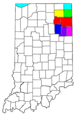
The Fort Wayne, IN Metropolitan Statistical Area, or Northeast Indiana, is a federally designated metropolitan area consisting of three counties in northeastern Indiana (Allen, Wells, and Whitley counties), anchored by the city of Fort Wayne. As of the 2010 census, the MSA had a population of 416,257[1][2] (though a July 1, 2011 estimate placed the population at 419,453).[2] The Fort Wayne metropolitan area is part of the Northern Indiana region, containing about 2.2 million people, and is considered part of the Great Lakes Megalopolis, which contains an estimated 59 million people.
Counties
| Census | Pop. | Note | %± |
|---|---|---|---|
| 1970 | 327,661 | — | |
| 1980 | 345,971 | 5.6% | |
| 1990 | 354,435 | 2.4% | |
| 2000 | 390,156 | 10.1% | |
| 2010 | 416,257 | 6.7% | |
| 2016 (est.) | 432,801 | [3] | 4.0% |
| U.S. Decennial Census[4] | |||
Communities
Places with more than 100,000 inhabitants
- Fort Wayne (Principal city)
Places with 10,000 to 100,000 inhabitants
Places with 1,000 to 10,000 inhabitants
- Bluffton
- Churubusco
- Columbia City
- Grabill
- Huntertown
- Leo-Cedarville
- Markle (partial)
- Monroeville
- Ossian
- South Whitley
- Woodburn
Places with less than 1,000 inhabitants
Census-designated places (CDPs)
Townships
Allen County
|
|
Wells County
|
|
Whitley County
|
|
Combined Statistical Area

As of February 2013[update], the Fort Wayne–Huntington–Auburn Combined Statistical Area (CSA) is made up of eight counties.[5] The statistical area includes one metropolitan area and five micropolitan areas. As of the 2012 Census estimate, the CSA has a population of 616,785.[6]
- Metropolitan Statistical Areas (MSAs)
- Fort Wayne (Allen, Wells, and Whitley counties)
- Micropolitan Statistical Areas (μSAs)
Notable residents
- Chris Schenkel, former Sportscaster for ABC Sports. Born in Bippus.[7]
See also
References
- ^ "U.S. Census website". United States Census Bureau. Retrieved January 31, 2008.
- ^ a b "Metropolitan and Micropolitan Statistical Areas". U.S. Census Bureau. July 1, 2011. Archived from the original on October 20, 2013. Retrieved Oct 19, 2013.
- ^ "US Census QuickFacts". Retrieved March 26, 2016.
- ^ United States Census Bureau. "Census of Population and Housing". Retrieved June 24, 2016.
- ^ "Fort Wayne-Huntington-Auburn, IN Combined Statistical Area" (PDF). United States Census Bureau. 2014-05-05. Retrieved 2018-10-28.
- ^ "Table 2. Annual Estimates of the Population of Combined Statistical Areas: April 1, 2010 to July 1, 2012" (CSV). 2012 Population Estimates. United States Census Bureau, Population Division. March 2013. Retrieved June 25, 2013.
- ^ http://yesteryear.clunette.com/schenkel.html

