Rural Municipality of Coalfields No. 4: Difference between revisions
→top: accidentally entered 2011 population rather than intended 2016 population |
→Statistics: update with most recent federal census(es) |
||
| Line 29: | Line 29: | ||
The '''Rural Municipality of Coalfields No. 4''' ([[Canada 2016 Census|2016 population]]: {{nts|368}}) is a [[rural municipality]] (RM) in the [[Provinces and territories of Canada|Canadian province]] of [[Saskatchewan]] within [[Division No. 1, Saskatchewan|Census Division No. 1]] and [[SARM Division No. 1|{{abbr|SARM|Saskatchewan Association of Rural Municipalities}} Division No. 1]]. Located in the southeast portion of the province, it is adjacent to the [[United States]], neighbouring [[Burke County, North Dakota|Burke County]], [[North Dakota]]. |
The '''Rural Municipality of Coalfields No. 4''' ([[Canada 2016 Census|2016 population]]: {{nts|368}}) is a [[rural municipality]] (RM) in the [[Provinces and territories of Canada|Canadian province]] of [[Saskatchewan]] within [[Division No. 1, Saskatchewan|Census Division No. 1]] and [[SARM Division No. 1|{{abbr|SARM|Saskatchewan Association of Rural Municipalities}} Division No. 1]]. Located in the southeast portion of the province, it is adjacent to the [[United States]], neighbouring [[Burke County, North Dakota|Burke County]], [[North Dakota]]. |
||
== |
== Demographics == |
||
In the [[2016 Canadian Census|2016 Census of Population]] conducted by [[Statistics Canada]], the RM of Coalfields No. 4 recorded a population of {{nts|368}} living in {{nts|148}} of its {{nts|183}} total private dwellings, a {{percentage|{{#expr:368-382}}|382|1}} change from its 2011 population of {{nts|382}}. With a land area of {{convert|819.52|km2|sqmi|abbr=on}}, it had a population density of {{Pop density|368|819.52|km2|sqmi|prec=1}} in 2016.<ref name=2016censusSKmunis>{{cite web | url=https://www12.statcan.gc.ca/census-recensement/2016/dp-pd/hlt-fst/pd-pl/Table.cfm?Lang=Eng&T=302&SR=1&S=86&O=A&RPP=9999&PR=47 | title=Population and dwelling counts, for Canada, provinces and territories, and census subdivisions (municipalities), 2016 and 2011 censuses – 100% data (Saskatchewan) | publisher=[[Statistics Canada]] | date=February 8, 2017 | accessdate=May 1, 2020}}</ref> |
|||
In the [[2011 Canadian Census|2011 Census of Population]], the RM of Coalfields No. 4 recorded a population of {{nts|382}}, a {{percentage|{{#expr:382-396}}|396|1}} change from its 2006 population of {{nts|396}}. With a land area of {{convert|819.52|km2|sqmi|abbr=on}}, it had a population density of {{Pop density|382|819.52|km2|sqmi|prec=1}} in 2011.<ref name=2011censusSKmunis>{{cite web | url=https://www12.statcan.gc.ca/census-recensement/2011/dp-pd/hlt-fst/pd-pl/Table-Tableau.cfm?LANG=Eng&T=302&SR=1&S=51&O=A&RPP=9999&PR=47&CMA=0 | title=Population and dwelling counts, for Canada, provinces and territories, and census subdivisions (municipalities), 2011 and 2006 censuses (Saskatchewan) | publisher=[[Statistics Canada]] | date=June 3, 2019 | accessdate=May 1, 2020}}</ref> |
|||
==Communities== |
==Communities== |
||
Revision as of 04:55, 2 May 2020
Coalfields No. 4 | |
|---|---|
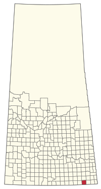
 Location within Saskatchewan | |
| Country | Canada |
| Province | Saskatchewan |
| Federal riding | Souris--Moose Mountain |
| Provincial riding | Estevan |
| Government | |
| • Reeve | Richard Tessier[1] |
| • Governing body | RM Council |
| • Office location | Bienfait |
| Population (2016) | |
• Total | 368 |
| Time zone | CST |
| Postal code | S0C 0M0 |
| Website | Official website |
The Rural Municipality of Coalfields No. 4 (2016 population: 368) is a rural municipality (RM) in the Canadian province of Saskatchewan within Census Division No. 1 and SARM Division No. 1. Located in the southeast portion of the province, it is adjacent to the United States, neighbouring Burke County, North Dakota.
Demographics
In the 2016 Census of Population conducted by Statistics Canada, the RM of Coalfields No. 4 recorded a population of 368 living in 148 of its 183 total private dwellings, a -3.7% change from its 2011 population of 382. With a land area of 819.52 km2 (316.42 sq mi), it had a population density of 0.4/km2 (1.2/sq mi) in 2016.[2]
In the 2011 Census of Population, the RM of Coalfields No. 4 recorded a population of 382, a -3.5% change from its 2006 population of 396. With a land area of 819.52 km2 (316.42 sq mi), it had a population density of 0.5/km2 (1.2/sq mi) in 2011.[3]
Communities
This is a list of communities within the municipality.
Towns
Villages
Hamlets
See also
References
- ^ Canada, Government of Saskatchewan. "Municipality Details".
- ^ "Population and dwelling counts, for Canada, provinces and territories, and census subdivisions (municipalities), 2016 and 2011 censuses – 100% data (Saskatchewan)". Statistics Canada. February 8, 2017. Retrieved May 1, 2020.
- ^ "Population and dwelling counts, for Canada, provinces and territories, and census subdivisions (municipalities), 2011 and 2006 censuses (Saskatchewan)". Statistics Canada. June 3, 2019. Retrieved May 1, 2020.
- ^ SGS Sask Cemeteries by RM No.
Template:Saskatchewan rural municipalities navbox 49°07′50″N 102°36′39″W / 49.13056°N 102.61083°W

