Skakavac (Sarajevo): Difference between revisions
m Refs |
Info box |
||
| Line 5: | Line 5: | ||
}} |
}} |
||
{{Infobox waterfall |
{{Infobox waterfall |
||
| name = |
| name = Skakavac |
||
| image = |
| image = |
||
| image_size = |
| image_size = |
||
| Line 18: | Line 18: | ||
| number_drops = |
| number_drops = |
||
| width = |
| width = |
||
| average_width =1505 |
| average_width = 1505{{what|date=August 2020}}{{fact|date=August 2020}} |
||
| run = 600 |
| run = 600{{what|date=August 2020}}{{fact|date=August 2020}} |
||
| watercourse = Skakavac |
| watercourse = Skakavac |
||
| average_flow = 908 |
| average_flow = 908{{what|date=August 2020}}{{fact|date=August 2020}} |
||
| world_rank = |
| world_rank = |
||
| type = |
| type = |
||
}} |
}} |
||
'''[[Skakavac]]''' (English: [[grasshopper]]) is situated 12 km from [[Sarajevo]], above the village of [[Nahorevo]].<ref>{{Cite web|last=DestiMap.com|title=Skakavac, Sarajevo Canton|url=https://www.destimap.com/index.php?act=attraction&a=Skakavac,-Sarajevo-Canton,-Bosnia-And-Herzegovina|access-date=2020-08-06|website=DestiMap|language=en}}</ref> It is one of the largest waterfalls in the Balkans with a height of 98 meters. The [[waterfall]] originates from a stream of the same name. It flows below the peak of Bukovik (1532 m) and into the Perak creek. Vegetation around the waterfall consists of various endemic and relict plants. Nearby trails are frequented by mountain bikers as well as hikers of differing experiences. |
'''[[Skakavac]]''' (English: [[grasshopper]]) is situated 12 km from [[Sarajevo]], above the village of [[Nahorevo]].<ref>{{Cite web|last=DestiMap.com|title=Skakavac, Sarajevo Canton|url=https://www.destimap.com/index.php?act=attraction&a=Skakavac,-Sarajevo-Canton,-Bosnia-And-Herzegovina|access-date=2020-08-06|website=DestiMap|language=en}}</ref> It is one of the largest waterfalls in the Balkans with a height of 98 meters. The [[waterfall]] originates from a stream of the same name. It flows below the peak of Bukovik (1532 m) and into the Perak creek. Vegetation around the waterfall consists of various endemic and relict plants. Nearby trails are frequented by mountain bikers as well as hikers of differing experiences. |
||
In 2002 the Skakavac waterfall and its surroundings were declared as a monument of nature by [[Sarajevo Canton]].<ref>{{cite web| title=Zaštita šireg područja vodopada „Skakavac“ | url=http://www.spomenici-sa.ba/spomenici-prirode/item/80-skakavac |website=www.spomenici-sa.ba|language=bs-ba}}</ref> |
In 2002, the Skakavac waterfall and its surroundings were declared as a monument of nature by [[Sarajevo Canton]].<ref>{{cite web| title=Zaštita šireg područja vodopada „Skakavac“ | url=http://www.spomenici-sa.ba/spomenici-prirode/item/80-skakavac |website=www.spomenici-sa.ba|language=bs-ba}}</ref> |
||
Skakavac Waterfall is a BASE jump location, popularly known as Gogo Base Jump Skakavac.<ref name="promo">{{Cite web| title=Waterfall Skakavac | work=Feel Bosnia | url=http://feelbosnia.com/what_to_see_bosnia/attraction/waterfall_skakavac/ | access-date=2020-08-06| publisher=Promo Tours }}</ref> |
Skakavac Waterfall is a BASE jump location, popularly known as Gogo Base Jump Skakavac.<ref name="promo">{{Cite web| title=Waterfall Skakavac | work=Feel Bosnia | url=http://feelbosnia.com/what_to_see_bosnia/attraction/waterfall_skakavac/ | access-date=2020-08-06| publisher=Promo Tours }}</ref> |
||
Revision as of 13:17, 21 August 2020
This article has multiple issues. Please help improve it or discuss these issues on the talk page. (Learn how and when to remove these messages)
|
| Skakavac | |
|---|---|
 | |
| Location | Sarajevo Canton, Bosnia and Herzegovina |
| Coordinates | 43°56′55.04″N 18°26′55.83″E / 43.9486222°N 18.4488417°E |
| Elevation | 980 metres (3,220 ft) |
| Total height | 98 metres (322 ft) |
| Average width | 1505[clarification needed][citation needed] |
| Run | 600[clarification needed][citation needed] |
| Watercourse | Skakavac |
| Average flow rate | 908[clarification needed][citation needed] |
Skakavac (English: grasshopper) is situated 12 km from Sarajevo, above the village of Nahorevo.[1] It is one of the largest waterfalls in the Balkans with a height of 98 meters. The waterfall originates from a stream of the same name. It flows below the peak of Bukovik (1532 m) and into the Perak creek. Vegetation around the waterfall consists of various endemic and relict plants. Nearby trails are frequented by mountain bikers as well as hikers of differing experiences.
In 2002, the Skakavac waterfall and its surroundings were declared as a monument of nature by Sarajevo Canton.[2]
Skakavac Waterfall is a BASE jump location, popularly known as Gogo Base Jump Skakavac.[3]
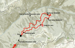
Round tour trail

The trailhead can be reached either by foot, car, or bus. Visitors might take any transport and carry on into the Skakavac Waterfall from Nahorevo using avenues.
The main waterfall may be reached by car directly from Sarajevo through Nahorevo, the Nature Preserve Skakavac.[3] Cars are prohibited after the stop ramp, although it is possible to hike down to the waterfall. It is also possible to reach the Skakavac Waterfall on foot, hiking through trails that lead under the waterfall.[3] Resting areas are available along the trail.
 |
 |
 |
 |
See also
- Skakavac Waterfall, Perućica, the second eponymous waterfall in Bosnia
References
- ^ DestiMap.com. "Skakavac, Sarajevo Canton". DestiMap. Retrieved 2020-08-06.
- ^ "Zaštita šireg područja vodopada „Skakavac"". www.spomenici-sa.ba (in Bosnian).
- ^ a b c "Waterfall Skakavac". Feel Bosnia. Promo Tours. Retrieved 2020-08-06.
External links
 Media related to Skakavac Waterfall (Sarajevo) at Wikimedia Commons


