Agrestina: Difference between revisions
Appearance
Content deleted Content added
updated pop. |
Isaidnoway (talk | contribs) unused LDR |
||
| Line 327: | Line 327: | ||
==References== |
==References== |
||
{{reflist |
{{reflist|refs= |
||
<ref name="h">{{cite web|url=http://www.agrestina.pe.gov.br/canais/turismo/conheca-agrestina |title=CONHEÇA AGRESTINA |year=2015 |publisher=Prefeitura Municipal de Agrestina |location=Agrestina, Pernambuco, Brazil |accessdate=2015-08-27 |language=Portuguese }}{{dead link|date=June 2017 |bot=InternetArchiveBot |fix-attempted=yes }}</ref> |
<ref name="h">{{cite web|url=http://www.agrestina.pe.gov.br/canais/turismo/conheca-agrestina |title=CONHEÇA AGRESTINA |year=2015 |publisher=Prefeitura Municipal de Agrestina |location=Agrestina, Pernambuco, Brazil |accessdate=2015-08-27 |language=Portuguese }}{{dead link|date=June 2017 |bot=InternetArchiveBot |fix-attempted=yes }}</ref> |
||
<ref name="i">{{cite web | url = http://cod.ibge.gov.br/102I | title = Agrestina | year = 2015 | publisher = Instituto Brasileiro de Geografia e Estatística | location = Brasília, Brazil | accessdate = 2015-08-27 | language = Portuguese}}</ref> |
|||
}} |
}} |
||
Revision as of 16:37, 19 January 2021
Agrestina | |
|---|---|
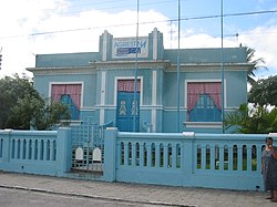
 City Hall of Agrestina | |
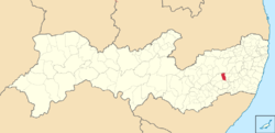
 Location of Agrestina in Pernambuco | |
| Coordinates: 8°27′S 35°57′W / 8.450°S 35.950°W | |
| Country | |
| State | Pernambuco |
| Region | Agreste |
| Government | |
| • Mayor | Thiago Nunes (PDT, 2013–2016) |
| Area | |
• Total | 200.58 km2 (77.44 sq mi) |
| Elevation | 427 m (1,401 ft) |
| Population (2020 [1]) | |
• Total | 25,065 |
| • Density | 120/km2 (320/sq mi) |
| Demonym | Agrestinense |
| Time zone | UTC-3 (BRT) |
| Average Temperature | 23.4 C |

Agrestina (Wilding) is a Brazilian municipality in the state of Pernambuco, mesoregion of Agreste. It covers 200.58 km2 (77.44 sq mi), and has a population of 25,065 with a population density of 113 inhabitants per square kilometer.
Geography
- State - Pernambuco
- Region - Agreste of Pernambuco
- Boundaries - Caruaru and Bezerros (N); Cupira (S); São Joaquim do Monte (E); Altinho (W)
- Area - 200.58 km2 (77.44 sq mi)
- Elevation - 427 kilometres (265 mi)
- Hydrography - Una River
- Vegetation - Hiperxerófila caatinga
- Climate - Transition between tropical (coastal) and semi arid
- Annual average temperature - 23.4 c
- Distance to Recife - 150 kilometres (93 mi)
Economy
The main economic activities in Agrestina are based in general commerce, industry and agribusiness. Especially, manioc and, creations of cattle, goats and sheep.
Economic Indicators
| Population [2] | GDP x(1000 R$).[3] | GDP pc (R$) | PE |
|---|---|---|---|
| 22.591 | 85.752 | 3.997 | 0.14% |
Economy by Sector 2006
| Primary sector | Secondary sector | Service sector |
|---|---|---|
| 19.29% | 12.90% | 67.81% |
Health Indicators
| HDI (2000) | Hospitals (2007) | Hospitals beds (2007) | Children's Mortality every 1000 (2005) |
|---|---|---|---|
| 0.612 | 1 | 72 | 33.8 |
History
Agrestina was founded in 1884 so Bebedouro, and became a district of Altinho in 1911. It became an independent municipality in 1928 under the name of Bebedouro, which was changed to Agrestina in 1943.[5]
References
- ^ IBGE 2020
- ^ http://www.ibge.gov.br/home/estatistica/populacao/estimativa2009/POP2009_DOU.pdf IBGE Population 2009 Agrestina, page 31]
- ^ Agrestina 2007 GDP IBGE pag 29 Archived 2016-03-04 at the Wayback Machine
- ^ PE State site - City by city profile
- ^ "CONHEÇA AGRESTINA" (in Portuguese). Agrestina, Pernambuco, Brazil: Prefeitura Municipal de Agrestina. 2015. Retrieved 2015-08-27.[permanent dead link]
Wikimedia Commons has media related to Agrestina.


