Kumya County: Difference between revisions
Adding missing coords |
Replaced {{unreferenced}} with {{more citations needed}} and other General fixes |
||
| Line 1: | Line 1: | ||
{{ |
{{more citations needed|date=January 2021}} |
||
{{Infobox settlement |
{{Infobox settlement |
||
<!-- See Template:Infobox settlement for additional fields and descriptions --> |
<!-- See Template:Infobox settlement for additional fields and descriptions --> |
||
| Line 110: | Line 110: | ||
==Transport== |
==Transport== |
||
The county is served by rail and road. Kŭmya Station is on the [[Pyongra Line|P'yongra Line]] of the [[Korean State Railway]]. The road system is well-developed, thanks to the level terrain. |
The county is served by rail and road. Kŭmya Station is on the [[Pyongra Line|P'yongra Line]] of the [[Korean State Railway]]. The road system is well-developed, thanks to the level terrain. |
||
==Claim by South Korea== |
==Claim by South Korea== |
||
Due to the specific nature of inter-korea relationship, the subdivision is not recognized by its current assignment that is happening in North Korea by the South Korean government. South Korea claims the name of the North Korean county is Yŏnghŭng(永興) county(the former name of the subdivision) through the [[Committee for the Five Northern Korean Provinces]].<ref>https://namu.wiki/enwiki/w/%EC%98%81%ED%9D%A5%EA%B5%B0?from=%EC%98%81%ED%9D%A5</ref> |
Due to the specific nature of inter-korea relationship, the subdivision is not recognized by its current assignment that is happening in North Korea by the South Korean government. South Korea claims the name of the North Korean county is Yŏnghŭng(永興) county(the former name of the subdivision) through the [[Committee for the Five Northern Korean Provinces]].<ref>https://namu.wiki/enwiki/w/%EC%98%81%ED%9D%A5%EA%B5%B0?from=%EC%98%81%ED%9D%A5</ref> |
||
| Line 116: | Line 117: | ||
*[[Geography of North Korea]] |
*[[Geography of North Korea]] |
||
*[[Administrative divisions of North Korea]] |
*[[Administrative divisions of North Korea]] |
||
==References== |
==References== |
||
{{Reflist}} |
{{Reflist}} |
||
Revision as of 21:31, 26 January 2021
This article needs additional citations for verification. (January 2021) |
Kumya County
금야군 | |
|---|---|
| Korean transcription(s) | |
| • Chosŏn'gŭl | 금야군 |
| • Hancha | 金野郡 |
| • McCune-Reischauer | Kŭmya kun |
| • Revised Romanization | Geumya-gun |
 Kŭmya-ŭp, Kŭmya County | |
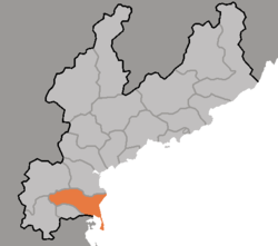
 Map of South Hamgyong showing the location of Kumya | |
| Country | North Korea |
| Province | South Hamgyong Province |
| Administrative divisions | 1 ŭp, 4 workers' districts, 50 ri |
Kŭmya County is a county in South Hamgyŏng province, North Korea. It borders the Sea of Japan (East Sea of Korea) to the east.
Physical features
To the west, there are high mountains but the eastern portion of the county is flat. The highest peak is Chŏngamsan (정암산). The chief river is the Ryonghŭng. Several islands are situated around the Songjŏn Bay (송전만). Forestland makes up about 30% of the county's area.
Administrative divisions
Kŭmya county is divided into 1 ŭp (town), 4 rodongjagu (workers' districts) and 50 ri (villages):
|
|
Economy
Agriculture and fishery
The chief form of agriculture in the county is rice cultivation. In addition, maize, soybeans, and wheat are produced; there are also orchards. There are no ports, although some fishing is done along the coast.
Mining and manufacturing
Machine industry has been well-developed in the region. There are also mines exploiting the local deposits of lignite, graphite, and gold.
Transport
The county is served by rail and road. Kŭmya Station is on the P'yongra Line of the Korean State Railway. The road system is well-developed, thanks to the level terrain.
Claim by South Korea
Due to the specific nature of inter-korea relationship, the subdivision is not recognized by its current assignment that is happening in North Korea by the South Korean government. South Korea claims the name of the North Korean county is Yŏnghŭng(永興) county(the former name of the subdivision) through the Committee for the Five Northern Korean Provinces.[1]
See also
References
External links
- In Korean language online encyclopedias:

