Gradiška, Bosnia and Herzegovina: Difference between revisions
No edit summary Tag: Reverted |
No edit summary |
||
| Line 57: | Line 57: | ||
[[File:Gradiškabypopulation1.png|thumb|286x286px|Gradiška municipality by population proportional to the settlement with the highest and lowest population]] |
[[File:Gradiškabypopulation1.png|thumb|286x286px|Gradiška municipality by population proportional to the settlement with the highest and lowest population]] |
||
'''Gradiška''' ({{lang-sr-Cyrl|Градишка}}) formerly Bosanska Gradiška (Босанска Градишка)<ref name="гх">[http://www.opstina-gradiska.com/ the official web site of the municipality] Gradiška/Градишка.</ref><ref>{{cite web|title=Systemic census of municipalities and populated places of Bosnia and Herzegovina|url=http://www.fzs.ba/Dem/Popis/nas_mjestaBiH.pdf|publisher=Agency for Statistics of Bosnia and Herzegovina|access-date=16 July 2015|location=Sarajevo|page=7|format=PDF|date=2013|url-status=dead|archive-url=https://web.archive.org/web/20160305101405/http://www.fzs.ba/Dem/Popis/nas_mjestaBiH.pdf|archive-date=5 March 2016}}</ref><ref>{{cite web|title=Preliminary results of the 2013 Census of Population, Households and Dwellings in Bosnia and Herzegovina|url=http://www.bhas.ba/obavjestenja/Preliminarni_rezultati_bos.pdf|website=bhas.ba|publisher=Agency for Statistics of Bosnia and Herzegovina|access-date=16 July 2015|location=Sarajevo|page=8|date=5 November 2013}}</ref> is a city and municipality located in the northwestern region of [[Republika Srpska]], an entity of [[Bosnia and Herzegovina]]. As of 2013, it has a population of 51,727 inhabitants, while the city of Gradiška has a population of 14,368 inhabitants. |
'''Gradiška''' ({{lang-sr-Cyrl|Градишка}}) formerly ''Bosanska Gradiška'' (Босанска Градишка)<ref name="гх">[http://www.opstina-gradiska.com/ the official web site of the municipality] Gradiška/Градишка.</ref><ref>{{cite web|title=Systemic census of municipalities and populated places of Bosnia and Herzegovina|url=http://www.fzs.ba/Dem/Popis/nas_mjestaBiH.pdf|publisher=Agency for Statistics of Bosnia and Herzegovina|access-date=16 July 2015|location=Sarajevo|page=7|format=PDF|date=2013|url-status=dead|archive-url=https://web.archive.org/web/20160305101405/http://www.fzs.ba/Dem/Popis/nas_mjestaBiH.pdf|archive-date=5 March 2016}}</ref><ref>{{cite web|title=Preliminary results of the 2013 Census of Population, Households and Dwellings in Bosnia and Herzegovina|url=http://www.bhas.ba/obavjestenja/Preliminarni_rezultati_bos.pdf|website=bhas.ba|publisher=Agency for Statistics of Bosnia and Herzegovina|access-date=16 July 2015|location=Sarajevo|page=8|date=5 November 2013}}</ref> is a city and municipality located in the northwestern region of [[Republika Srpska]], an entity of [[Bosnia and Herzegovina]]. As of 2013, it has a population of 51,727 inhabitants, while the city of Gradiška has a population of 14,368 inhabitants. |
||
It is geographically located in eastern [[Bosanska Krajina|Krajina]] region, and the town is situated on the [[Lijevče]] plain, on the right bank of the [[Sava]] river across from [[Stara Gradiška]], [[Croatia]], and about {{convert|40|km|mi|0|abbr=on}} north of [[Banja Luka]]. |
It is geographically located in eastern [[Bosanska Krajina|Krajina]] region, and the town is situated on the [[Lijevče]] plain, on the right bank of the [[Sava]] river across from [[Stara Gradiška]], [[Croatia]], and about {{convert|40|km|mi|0|abbr=on}} north of [[Banja Luka]]. |
||
Revision as of 03:56, 3 February 2021
Gradiška
Градишка | |
|---|---|
City of Gradiška | |
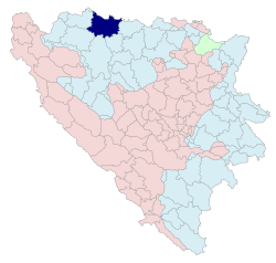
 Location of Gradiška within Republika Srpska | |
 | |
| Coordinates: 45°08′45″N 17°15′14″E / 45.14583°N 17.25389°E | |
| Country | |
| Entity | |
| Government | |
| • Mayor | Zoran Adžić (SNSD) |
| • Municipality | 761.74 km2 (294.11 sq mi) |
| Elevation | 163 m (535 ft) |
| Population (2013 census) | |
| • Municipality | 51,727 |
| Time zone | UTC+1 (CET) |
| • Summer (DST) | UTC+2 (CEST) |
| Postal code | 78400 |
| Area code | +387 51 |
| Website | www |

Gradiška (Serbian Cyrillic: Градишка) formerly Bosanska Gradiška (Босанска Градишка)[1][2][3] is a city and municipality located in the northwestern region of Republika Srpska, an entity of Bosnia and Herzegovina. As of 2013, it has a population of 51,727 inhabitants, while the city of Gradiška has a population of 14,368 inhabitants.
It is geographically located in eastern Krajina region, and the town is situated on the Lijevče plain, on the right bank of the Sava river across from Stara Gradiška, Croatia, and about 40 km (25 mi) north of Banja Luka.
History
In the Roman period this town was of strategic importance; a port of the Roman fleet was situated here. Among notable archaeological findings are a viaduct.
Gradiški Brod is mentioned for the first time as a town in c. 1330. It had a major importance as the location where the Sava river used to be crossed. By 1537, the town and its surroundings came under Ottoman rule.
The Ottoman built a fortress, which served as the Bosnia Eyalet's northern defense line. The town was also called Berbir because of the fortress.
Following the outbreak of the First Serbian Uprising (1804), in the Sanjak of Smederevo (modern Central Serbia), the Jančić's Revolt broke out in the Gradiška region against the Ottoman government in the Bosnia Eyalet, following the erosion of the economic, national and religious rights of Serbs. Hajduks also arrived from Serbia, and were especially active on the Kozara. Jovan Jančić Sarajlija organized the uprising with help from Metropolitan Benedikt Kraljević. The peasants took up arms on 23 September 1809, in the region of Gradiška, beginning from Mašići. The fighting began on 25 September, and on the same night, the Ottomans captured and executed Jančić. The rebels retreated to their villages, except those in Kozara and Motajica who continued, and offered strong resistance until their defeat in mid-October, after extensive looting and burning of villages by the Ottomans.[4] Another revolt broke out in 1834, in Mašići.[5]
Ottoman rule ended with the Austro-Hungarian occupation of Bosnia and Herzegovina (1878), following the Herzegovina Uprising (1875–77). Austro-Hungarian rule in Bosnia and Herzegovina ended in 1918, when the South Slavic Austro-Hungarian territories proclaimed the State of Slovenes, Croats and Serbs, which subsequently joined the Kingdom of Serbia into the Kingdom of Yugoslavia.
From 1929 to 1941 Gradiška was part of the Vrbas Banovina of the Kingdom of Yugoslavia.
During Yugoslavia, the town was known as Bosanska Gradiška (Босанска Градишка). During the Bosnian War, the town was incorporated into Republika Srpska (RS). After the war, the RS National Assembly changed the name, omitting bosanska ("Bosnian"), as was done with many other towns (Kostajnica, Dubica, Novi Grad, Petrovo, Šamac).
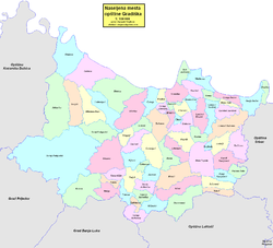
Settlements
Aside from the town of Gradiška, the municipality includes total of 74 other settlements:
Demographics
Population
| Population of settlements – Gradiška municipality | |||||||||||||
|---|---|---|---|---|---|---|---|---|---|---|---|---|---|
| Settlement | 1885. | 1895. | 1910. | 1921. | 1931. | 1948 | 1953. | 1961. | 1971. | 1981. | 1991. | 2013. | |
| Total | 29,962 | 37,797 | 41,868 | 45,190 | 57,235 | 46,013 | 48,056 | 50,143 | 53,581 | 58,095 | 59,974 | 51,727 | |
| 1 | Berek | 482 | 412 | ||||||||||
| 2 | Bistrica | 795 | 432 | ||||||||||
| 3 | Bok Jankovac | 754 | 1,161 | ||||||||||
| 4 | Brestovčina | 360 | 1,027 | ||||||||||
| 5 | Bukovac | 349 | 371 | ||||||||||
| 6 | Čatrnja | 768 | 697 | ||||||||||
| 7 | Cerovljani | 604 | 367 | ||||||||||
| 8 | Čikule | 369 | 255 | ||||||||||
| 9 | Cimiroti | 331 | 202 | ||||||||||
| 10 | Donji Karajzovci | 600 | 548 | ||||||||||
| 11 | Donji Podgradci | 957 | 758 | ||||||||||
| 12 | Dubrave | 2,581 | 1,534 | ||||||||||
| 13 | Elezagići | 561 | 528 | ||||||||||
| 14 | Gašnica | 443 | 324 | ||||||||||
| 15 | Gornja Lipovača | 992 | 500 | ||||||||||
| 16 | Gornji Karajzovci | 537 | 484 | ||||||||||
| 17 | Gornji Podgradci | 2,378 | 1,656 | ||||||||||
| 18 | Gradiška | 5,590 | 9,932 | 6,363 | 9,585 | 13.475 | 16,841 | 14,368 | |||||
| 19 | Grbavci | 991 | 594 | ||||||||||
| 20 | Jablanica | 745 | 438 | ||||||||||
| 21 | Kijevci | 381 | 212 | ||||||||||
| 22 | Kočićevo | 631 | 463 | ||||||||||
| 23 | Kozinci | 908 | 1,661 | ||||||||||
| 24 | Krajišnik | 528 | 617 | ||||||||||
| 25 | Kruškik | 1,074 | 1,119 | ||||||||||
| 26 | Laminci Brezici | 1,415 | 1,847 | ||||||||||
| 27 | Laminci Dubrave | 591 | 438 | ||||||||||
| 28 | Laminci Jaružani | 394 | 287 | ||||||||||
| 29 | Laminci Sređani | 574 | 456 | ||||||||||
| 30 | Liskovac | 1,467 | 1,080 | ||||||||||
| 31 | Lužani | 275 | 238 | ||||||||||
| 32 | Mačkovac | 476 | 266 | ||||||||||
| 33 | Mašići | 1,359 | 1,153 | ||||||||||
| 34 | Miloševo Brdo | 439 | 241 | ||||||||||
| 35 | Nova Topola | 2,191 | 2,324 | ||||||||||
| 36 | Orahova | 2,479 | 1,185 | ||||||||||
| 37 | Petrovo Selo | 358 | 329 | ||||||||||
| 38 | Rogolji | 741 | 668 | ||||||||||
| 39 | Romanovci | 1,199 | 976 | ||||||||||
| 40 | Rovine | 1,016 | 1,422 | ||||||||||
| 41 | Seferovci | 502 | 504 | ||||||||||
| 42 | Sovjak | 307 | 208 | ||||||||||
| 43 | Trebovljani | 425 | 348 | ||||||||||
| 44 | Trošelji | 550 | 559 | ||||||||||
| 45 | Turjak | 415 | 268 | ||||||||||
| 46 | Vakuf | 416 | 342 | ||||||||||
| 47 | Vilusi | 887 | 736 | ||||||||||
| 48 | Vrbaška | 1,057 | 779 | ||||||||||
| 49 | Žeravica | 335 | 482 | ||||||||||
Ethnic composition
| Ethnic composition – Gradiška city | |||||||
|---|---|---|---|---|---|---|---|
| Nationality | 2013. | 1991. | 1981. | 1971. | |||
| Total | 14,368 (100,0%) | 16,841 (100,0%) | 13,475 (100,0%) | 9,585 (100,0%) | |||
| Serbs | 11,122 (77,41%) | 6,502 (38,61%) | 4,251 (31,55%) | 2,911 (30,37%) | |||
| Bosniaks | 2,408 (16,76%) | 7,188 (42,68%) | 5,033 (37,35%) | 5,377 (56,10%) | |||
| Croats | 294 (2,046%) | 781 (4,637%) | 730 (5,417%) | 808 (8,430%) | |||
| Unaffiliated | 214 (1,489%) | ||||||
| Others | 174 (1,211%) | 582 (3,456%) | 99 (0,735%) | 121 (1,262%) | |||
| Yugoslavs | 38 (0,264%) | 1,788 (10,62%) | 3 218 (23,88%) | 306 (3,192%) | |||
| Roma | 34 (0,237%) | 42 (0,312%) | 9 (0,094%) | ||||
| Albanians | 29 (0,202%) | 44 (0,327%) | 25 (0,261%) | ||||
| Ukrainians | 17 (0,118%) | ||||||
| Unknown | 16 (0,111%) | ||||||
| Montenegrins | 14 (0,097%) | 29 (0,215%) | 12 (0,125%) | ||||
| Slovenes | 5 (0,035%) | 20 (0,148%) | 14 (0,146%) | ||||
| Macedonians | 3 (0,021%) | 9 (0,067%) | 2 (0,021%) | ||||
| Ethinc composition – Gradiška Municipality | |||||||
|---|---|---|---|---|---|---|---|
| Nationality | 2013. | 1991. | 1981. | 1971. | |||
| Total | 51,727 (100,0%) | 59,974 (100,0%) | 58,095 (100,0%) | 53,581 (100,0%) | |||
| Serbs | 41,863 (80,93%) | 35,753 (59,61%) | 32,825 (56,50%) | 35,038 (65,39%) | |||
| Bosniaks | 7,580 (14,65%) | 15,851 (26,43%) | 13,026 (22,42%) | 12,688 (23,68%) | |||
| Croats | 826 (1,597%) | 3,417 (5,697%) | 3,544 (6,100%) | 4,415 (8,240%) | |||
| Unaffiliated | 416 (0,804%) | ||||||
| Roma | 395 (0,764%) | 232 (0,399%) | 29 (0,054%) | ||||
| Others | 340 (0,657%) | 1,642 (2,738%) | 660 (1,136%) | 849 (1,585%) | |||
| Ukrainians | 111 (0,215%) | ||||||
| Yugoslavs | 76 (0,147%) | 3,311 (5,521%) | 7,638 (13,15%) | 415 (0,775%) | |||
| Unknown | 43 (0,083%) | ||||||
| Albanians | 30 (0,058%) | 70 (0,120%) | 56 (0,105%) | ||||
| Montenegrins | 29 (0,056%) | 57 (0,098%) | 61 (0,114%) | ||||
| Slovenes | 14 (0,027%) | 31 (0,053%) | 25 (0,047%) | ||||
| Macedonians | 4 (0,008%) | 12 (0,021%) | 5 (0,009%) | ||||
Culture


The town has a Serbian Orthodox cathedral dedicated to the Mother of God.
Economy
The following table gives a preview of total number of registered people employed in legal entities per their core activity (as of 2018):[6]
| Activity | Total |
|---|---|
| Agriculture, forestry and fishing | 320 |
| Mining and quarrying | 4 |
| Manufacturing | 2,916 |
| Electricity, gas, steam and air conditioning supply | 171 |
| Water supply; sewerage, waste management and remediation activities | 234 |
| Construction | 267 |
| Wholesale and retail trade, repair of motor vehicles and motorcycles | 1,956 |
| Transportation and storage | 452 |
| Accommodation and food services | 543 |
| Information and communication | 71 |
| Financial and insurance activities | 114 |
| Real estate activities | 24 |
| Professional, scientific and technical activities | 323 |
| Administrative and support service activities | 77 |
| Public administration and defense; compulsory social security | 581 |
| Education | 840 |
| Human health and social work activities | 661 |
| Arts, entertainment and recreation | 62 |
| Other service activities | 222 |
| Total | 9,838 |
Notable residents
- Marko Marin, German footballer
- Zvjezdan Misimović, Bosnian footballer
- Vaso Čubrilović, politician and historian, member of Black Hand organisation and participant in the conspiracy to kill Archduke Franz Ferdinand of Austria.
- Veljko Čubrilović, member of Black Hand organisation
- Vlado Jagodić, former footballer, now manager
- Vinko Marinović, former Serbian footballer, now manager
- Tatjana Pašalić, poker presenter
- Samson Morpurgo, Medieval Italian rabbi, physician, and liturgist
- Nordin Gerzić, Swedish footballer
- Alojzije Mišić, Roman Catholic bishop
- Branko Grahovac, football goalkeeper
- Atif Dudaković, Bosnian war-time army general
- Nazif Hajdarović, footballer
- Ratko Varda, basketball player
- Milan Janković, footballer
- Miodrag Latinović, retired footballer
- Zlatko Janjić, footballer
- Ozren Perić, footballer
- Safet Halilović, politician
- Ognjen Ožegović, Serbian footballer, European U-19 champion
- Goran Zakarić, Bosnian footballer
Twin towns – sister cities
 Kavala, Greece (1994)[7]
 Ćuprija, Serbia (1994)[citation needed]
 Negotino, North Macedonia (2006)[citation needed]
 Montesilvano, Italy (2018)[8]
See also
References
- ^ the official web site of the municipality Gradiška/Градишка.
- ^ "Systemic census of municipalities and populated places of Bosnia and Herzegovina" (PDF). Sarajevo: Agency for Statistics of Bosnia and Herzegovina. 2013. p. 7. Archived from the original (PDF) on 5 March 2016. Retrieved 16 July 2015.
- ^ "Preliminary results of the 2013 Census of Population, Households and Dwellings in Bosnia and Herzegovina" (PDF). bhas.ba. Sarajevo: Agency for Statistics of Bosnia and Herzegovina. 5 November 2013. p. 8. Retrieved 16 July 2015.
- ^ Стојан Бијелић. Машићка буна. Врбаске новине бр. 107 ст. 5, 1933. (извор)
- ^ :: Www.Gradiskasela.Net :: Archived 2009-09-25 at the Wayback Machine
- ^ "Cities and Municipalities of Republika Srpska" (PDF). rzs.rs.ba. Republika Srspka Institute of Statistics. 25 December 2019. Retrieved 31 December 2019.
- ^ "Ппосјета братском граду Кавала у Грчкој". gradgradiska.com (in Serbian). Gradiška. 2019-07-22. Retrieved 2020-12-29.
- ^ "Ппотписан споразум о братимљењу градишке и Монтесилвана". gradgradiska.com (in Serbian). Gradiška. 2018-04-30. Retrieved 2020-12-29.


