Tal Saki: Difference between revisions
Appearance
Content deleted Content added
JJMC89 bot (talk | contribs) Migrate {{Infobox mountain}} coordinates parameters to {{Coord}}, see Wikipedia:Coordinates in infoboxes |
No edit summary |
||
| Line 29: | Line 29: | ||
The hill is a part of a chain of dormant volcanic mountains spanning along the eastern part of the Golan Heights starting from [[Mount Ram]] in the north and ending on Tal Saki in the South. |
The hill is a part of a chain of dormant volcanic mountains spanning along the eastern part of the Golan Heights starting from [[Mount Ram]] in the north and ending on Tal Saki in the South. |
||
[[File:Tel Saki war memorial.JPG|thumb|Tel Saki memorial]] |
[[File:Tel Saki war memorial.JPG|thumb|Tel Saki memorial]] |
||
[[File:View from Tel Saki.jpg|thumb|The view from Tel Saki]] |
|||
[[Category:Golan Heights]] |
[[Category:Golan Heights]] |
||
[[Category:Landforms of the Golan Heights]] |
[[Category:Landforms of the Golan Heights]] |
||
Revision as of 03:53, 28 March 2021
| Tal El-Saki | |
|---|---|
| Arabic: Tal Al-Saki Hebrew: Tel Saki | |
 Tal El-Saki | |
| Highest point | |
| Elevation | 594 m (1,949 ft) |
| Coordinates | 32°51′59″N 35°49′50″E / 32.86639°N 35.83056°E |
| Geography | |
| Location | Golan Heights |
| Geology | |
| Mountain type | Volcano |
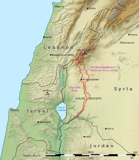
Tel Saki (Template:Lang-ar / ALA-LC: Tal Al-Saki; Template:Lang-he) is a dormant volcanic hill in the southeastern part of the Golan Heights. It extends to an elevation of 594 meters above sea level.
The hill is a part of a chain of dormant volcanic mountains spanning along the eastern part of the Golan Heights starting from Mount Ram in the north and ending on Tal Saki in the South.


