Fitovinany: Difference between revisions
Appearance
Content deleted Content added
→References: add authority control |
details |
||
| Line 52: | Line 52: | ||
|government_footnotes = |
|government_footnotes = |
||
|government_type = |
|government_type = |
||
|leader_title = |
|leader_title = Gouveneur |
||
|leader_name = |
|leader_name = Lucien Laurel Razafitsotra |
||
|leader_title1 = <!-- for places with, say, both a mayor and a city manager --> |
|leader_title1 = <!-- for places with, say, both a mayor and a city manager --> |
||
|leader_name1 = |
|leader_name1 = |
||
| Line 142: | Line 142: | ||
==Transportation mean== |
==Transportation mean== |
||
*Train (from Fianarantsoa) |
*Train - 180 km (from Fianarantsoa) |
||
*Car [[Taxi-Brousse]] |
*Car [[Taxi-Brousse]] |
||
* Two airports: |
|||
*Plane |
|||
**[[Manakara Airport]] |
**[[Manakara Airport]] |
||
**[[Mananjary Airport]] |
**[[Mananjary Airport]] |
||
| Line 153: | Line 153: | ||
*Part of [[Marolambo National Park]] |
*Part of [[Marolambo National Park]] |
||
*Part of [[Ranomafana National Park]] |
*Part of [[Ranomafana National Park]] |
||
==Economy= |
|||
==References== |
==References== |
||
* [https://beta.edbm.mg/fr/regions/vatovavy-fitovinany EBDM] |
|||
{{reflist}} |
{{reflist}} |
||
Revision as of 15:04, 7 May 2021
This article needs additional citations for verification. (December 2009) |
Vatovavy-Fitovinany | |
|---|---|
Region | |
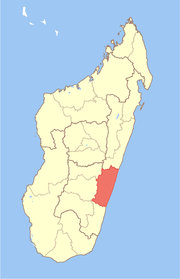
 Location in Madagascar | |
| Country | |
| Capital | Manakara |
| Government | |
| • Gouveneur | Lucien Laurel Razafitsotra |
| Area | |
• Total | 19,605 km2 (7,570 sq mi) |
| Population (2018)[2] | |
• Total | 1,435,882 |
| • Density | 73/km2 (190/sq mi) |
| Time zone | UTC3 (EAT) |
| HDI (2018) | 0.473[3] low · 14th of 22 |
Vatovavy-Fitovinany is a region located in southeast Madagascar. Its capital is Manakara. It is inhabited by the Antemoro people.
The region extends along the southern part of the east coast of Madagascar. It is bordered by Atsinanana (North), Amoron'i Mania and Haute Matsiatra (West) and Atsimo-Atsinanana (South).
Administrative divisions
Vatovavy-Fitovinany region is divided into six districts, which are sub-divided into 122 communes.
- Ifanadiana District
- Ikongo District
- Manakara District
- Mananjary District
- Nosy Varika District
- Vohipeno District
Transportation mean
- Train - 180 km (from Fianarantsoa)
- Car Taxi-Brousse
- Two airports:
- Manakara port is only used for product shipment and transit (Lychee, coffee, ...)
Protected areas
- Part of Fandriana-Vondrozo Corridor
- Part of Marolambo National Park
- Part of Ranomafana National Park
=Economy
References
- ^ Ralison, Eliane; Goossens, Frans. "Madagascar: Profil des marchés pour les évaluations d'urgence de la sécurité alimentaire" (PDF) (in French). Programme Alimentaire Mondial, Service de l’Evaluation des besoins d’urgence (ODAN). Retrieved 2008-03-01.
- ^ "Troisieme Recensement General de la Population et de L'Habitation (RGPH-3) Resultats Provisoires" (PDF). Institut National de la Statistique Madagascar. Retrieved May 23, 2020.
- ^ "Sub-national HDI - Area Database - Global Data Lab". hdi.globaldatalab.org. Retrieved 2018-09-13.
22°08′42″S 48°00′36″E / 22.14500°S 48.01000°E

