Læså Formation: Difference between revisions
Appearance
Content deleted Content added
Tisquesusa (talk | contribs) |
Add photo of Læså formation, as part of Wikipedia Pages Wanting Photos 2021 project #WPWP |
||
| Line 1: | Line 1: | ||
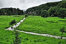
[[File:Ekkodalen - Læså.jpg|thumb|Læså running through the meadow in the bottom of Ekkodalen on the island of Bornholm, Denmark]] |
|||
{{Infobox rockunit |
{{Infobox rockunit |
||
| period = Lower Cambrian |
| period = Lower Cambrian |
||
Revision as of 17:04, 4 July 2021

| Læså Formation | |
|---|---|
Stratigraphic range: | |
| Type | Geological formation |
| Sub-units | Broens Odde Member, Rispebjerg Member |
| Overlies | Hardeberga Formation |
| Thickness | approx. 103 metres (340 ft) |
| Location | |
| Region | Bornholm |
| Country | |
The Læså Formation is a lower Cambrian unit exposed on the Baltic island Bornholm, comprising two members: the lower, the Broens Odde Member, colloquially and previously informally termed "green shales" (Grønne Skifre), a 100 m thick glauconitic silt-sandstone occasionally bearing extremely acritarch-rich phosphatic pebbles;[1] gradually transitioning upwards into the upper, the 3 m thick Rispebjerg Member, a sandstone.[2]
References
