Ramkot Fort: Difference between revisions
Revert to revision 997019408 dated 2020-12-29 17:09:43 by SalamAlayka using popups |
No edit summary Tag: Reverted |
||
| Line 3: | Line 3: | ||
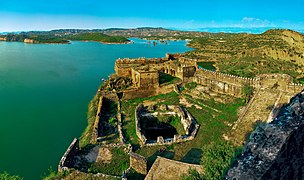
| caption = View of Ramkot Fort |
| caption = View of Ramkot Fort |
||
| name = Ramkot Fort |
| name = Ramkot Fort |
||
| location = [[Dadyal]], [[Mirpur district]], [[ |
| location = [[Dadyal]], [[Mirpur district]], [[Pakistan Occupied Kashmir]], [[Pakistan]] |
||
| start_date = 16th–17th century AD |
| start_date = 16th–17th century AD |
||
}} |
}} |
||
| Line 11: | Line 11: | ||
==Gallery== |
==Gallery== |
||
<gallery mode="packed"> |
<gallery mode="packed"> |
||
File:Ramkot Fort, Dadyal, |
File:Ramkot Fort, Dadyal, Pakistan Occupied Kashmir.jpg|Landscape view |
||
File:Ramkot Fort Mirpur.jpg|Bird's eye view |
File:Ramkot Fort Mirpur.jpg|Bird's eye view |
||
File:Ramkot Fort - The Courtyard.jpg|Courtyard |
File:Ramkot Fort - The Courtyard.jpg|Courtyard |
||
| Line 26: | Line 26: | ||
{{commons category}} |
{{commons category}} |
||
{{Cultural heritage sites in |
{{Cultural heritage sites in Pakistan Occupied Kashmir |state=autocollapse}} |
||
{{Cultural heritage sites in Pakistan}} |
{{Cultural heritage sites in Pakistan}} |
||
{{coord|33|13|N|73|38|E|display=title|region:PK_type:landmark_source:GNS-enwiki}}{{Castles in Pakistan}} |
{{coord|33|13|N|73|38|E|display=title|region:PK_type:landmark_source:GNS-enwiki}}{{Castles in Pakistan}} |
||
| Line 32: | Line 32: | ||
*[http://logicisvariable.blogspot.com/2011/11/fort-oblivion.html] |
*[http://logicisvariable.blogspot.com/2011/11/fort-oblivion.html] |
||
[[Category:Forts in |
[[Category:Forts in Pakistan Occupied Kashmir]] |
||
[[Category:Castles in Pakistan]] |
[[Category:Castles in Pakistan]] |
||
Revision as of 05:50, 28 July 2021
| Ramkot Fort | |
|---|---|
 View of Ramkot Fort | |
 | |
| General information | |
| Location | Dadyal, Mirpur district, Pakistan Occupied Kashmir, Pakistan |
| Construction started | 16th–17th century AD |
Ramkot Fort (Template:Lang-ur) is an ancient fort situated in Azad Jammu and Kashmir, Pakistan currently beside the Mangla Dam. It was built in 1186, it is accessible through boat, 13 kilometers away from Dina and 79 kilometers by road from Mirpur, Azad Kashmir to Dadyal town. It is also accessible from [Gujar Khan], via Jabbar and Notla then using boat. The fort is accessible from Siakh village from Dadyal side and Mangla through boats which take approximately 20 to 30 minutes. Three sides of the hilltop are surrounded by the Jhelum River, which falls into the huge reservoir of Mangla Dam. It was built by the Gakhar Sultan named Toglu as recorded by traveler and geologist Frederick Drew in his book.[1]
Gallery
-
Landscape view
-
Bird's eye view
-
Courtyard
See also
- List of UNESCO World Heritage Sites in Pakistan
- List of forts in Pakistan
- List of museums in Pakistan
References
- ^ Frederic Drew (1875-01-01). The Jummoo and Kashmir Territories: A Geographical Account. E. Stanford. p. 59.
Template:Cultural heritage sites in Pakistan Occupied Kashmir
33°13′N 73°38′E / 33.217°N 73.633°E


