Susanlıq: Difference between revisions
Appearance
Coordinates: Template:Xb_type:city(180) 39°34′10″N 46°55′47″E / 39.56944°N 46.92972°E
Content deleted Content added
AntonSamuel (talk | contribs) →History: Adding info about NKAO |
mNo edit summary Tags: Visual edit Mobile edit Mobile web edit |
||
| Line 1: | Line 1: | ||
{{Infobox settlement |
{{Infobox settlement |
||
|official_name = Susanlyg / Mokhrenes |
| official_name = Susanlyg / Mokhrenes |
||
|native_name = Susanlıq / Մոխրենես |
| native_name = Susanlıq / Մոխրենես |
||
|image_skyline = Եկեղեցի Օխտը դռնի։.jpg |
| image_skyline = Եկեղեցի Օխտը դռնի։.jpg |
||
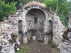
|image_caption = Church ruins in the village |
| image_caption = Church ruins in the village |
||
|pushpin_map = Azerbaijan#Republic of Artsakh |
| pushpin_map = Azerbaijan#Republic of Artsakh |
||
|pushpin_mapsize = 300 |
| pushpin_mapsize = 300 |
||
|subdivision_type = Country |
| subdivision_type = Country |
||
|subdivision_name = {{flag|Azerbaijan}} |
| subdivision_name = {{flag|Azerbaijan}} |
||
<br> {{flag|Republic of Artsakh}} (claimed) |
|||
|subdivision_type1 = [[Administrative divisions of Azerbaijan|District]] |
| subdivision_type1 = [[Administrative divisions of Azerbaijan|District]] |
||
|subdivision_name1 = [[Khojavend District|Khojavend]] |
|||
| |
| subdivision_name1 = [[Khojavend District|Khojavend]] |
||
| |
| leader_title = |
||
| |
| leader_name = |
||
| |
| established_title = |
||
| |
| established_date = |
||
| |
| area_total_km2 = |
||
| area_footnotes = |
|||
|population_footnotes = <ref name=2015statistics>{{Cite web|url=https://artsakhlib.am/en/2018/06/06/%D5%BF%D5%A5%D5%B2%D5%A5%D5%AF%D5%A1%D5%BF%D5%B8%D6%82-%D5%AC%D5%B2%D5%B0-%D5%BE%D5%A1%D6%80%D5%B9%D5%A1%D5%BF%D5%A1%D6%80%D5%A1%D5%AE%D6%84%D5%A1%D5%B5%D5%AB%D5%B6-%D5%B4%D5%AB%D5%A1%D5%BE%D5%B8/|title=Directory of socio-economic characteristics of NKR administrative-territorial units (2015)|author=Hakob Ghahramanyan}}</ref> |
| population_footnotes = <ref name=2015statistics>{{Cite web|url=https://artsakhlib.am/en/2018/06/06/%D5%BF%D5%A5%D5%B2%D5%A5%D5%AF%D5%A1%D5%BF%D5%B8%D6%82-%D5%AC%D5%B2%D5%B0-%D5%BE%D5%A1%D6%80%D5%B9%D5%A1%D5%BF%D5%A1%D6%80%D5%A1%D5%AE%D6%84%D5%A1%D5%B5%D5%AB%D5%B6-%D5%B4%D5%AB%D5%A1%D5%BE%D5%B8/|title=Directory of socio-economic characteristics of NKR administrative-territorial units (2015)|author=Hakob Ghahramanyan}}</ref> |
||
|population_as_of = 2015 |
|||
| |
| population_as_of = 2015 |
||
| population_total = 180 |
|||
|population_density_km2 = auto |
| population_density_km2 = auto |
||
|timezone = [[Azerbaijan Time|AZT]] |
|||
| |
| timezone = [[Azerbaijan Time|AZT]] |
||
| |
| utc_offset = +4 |
||
| |
| timezone_DST = |
||
|coordinates = {{coord|39|34|10|N|46|55|47|E|region:{{xb|NKR}}|display=inline,title}} |
| utc_offset_DST = |
||
| coordinates = {{coord|39|34|10|N|46|55|47|E|region:{{xb|NKR}}|display=inline,title}} |
|||
|elevation_m = |
| elevation_m = |
||
|area_code = |
| area_code = |
||
|website = |
| website = |
||
}} |
}} |
||
Revision as of 19:32, 6 August 2021
Susanlyg / Mokhrenes
Susanlıq / Մոխրենես | |
|---|---|
 Church ruins in the village | |
| Coordinates: Template:Xb_type:city(180) 39°34′10″N 46°55′47″E / 39.56944°N 46.92972°E | |
| Country | |
| District | Khojavend |
| Population (2015)[1] | |
• Total | 180 |
| Time zone | UTC+4 (AZT) |
Susanlıq (Susanlyg) or Mokhrenes (Template:Lang-hy) is a village in the Khojavend District of Azerbaijan. The village had an ethnic Armenian-majority population prior to the 2020 Nagorno-Karabakh war, and also had an Armenian majority in 1989.[2]
History
During the Soviet period, the village was a part of the Hadrut District of the Nagorno-Karabakh Autonomous Oblast.
The village was captured by Armenian forces during the First Nagorno-Karabakh War and was administrated as part of the Hadrut Province of the self-proclaimed Republic of Artsakh. The village was recaptured by Azerbaijan during the 2020 Nagorno-Karabakh war.[3]
References
- ^ Hakob Ghahramanyan. "Directory of socio-economic characteristics of NKR administrative-territorial units (2015)".
- ^ Андрей Зубов. "Андрей Зубов. Карабах: Мир и Война". drugoivzgliad.com.
- ^ "Azərbaycanın işğaldan azad edilmiş şəhər və kəndləri" [Liberated cities and villages of Azerbaijan]. TRT Azerbaijani (in Azerbaijani). 20 November 2020. Retrieved 28 January 2021.
External links
Wikimedia Commons has media related to Cultural heritage monuments in Mokhrenes, Nagorno-Karabakh.


