N70 highway: Difference between revisions
Appearance
Content deleted Content added
No edit summary |
No edit summary |
||
| Line 12: | Line 12: | ||
|spur_type=AH |
|spur_type=AH |
||
|spur_of=26 |
|spur_of=26 |
||
| |
|allocation={{jct|country=PHL|AH|N70}} from Palo to Ormoc |
||
|terminus_a={{jct|country=PHL|AH|N1|name1=[[Maharlika Highway]]}} in [[Palo, Leyte|Palo]] |
|||
|junction={{plainlist | |
|junction={{plainlist | |
||
* {{jct|country=PHL|N|681|name1=Lemon–Leyte–Biliran Road}} in [[Capoocan, Leyte|Capoocan]] |
* {{jct|country=PHL|N|681|name1=Lemon–Leyte–Biliran Road}} in [[Capoocan, Leyte|Capoocan]] |
||
| Line 29: | Line 30: | ||
}} |
}} |
||
The '''National Route 70''' ('''N70''') forms part of the [[Philippine highway network]]. It spurs the '''[[Asian Highway 26]]''' in [[Leyte]], Philippines.<ref>{{Cite web|url=http://www.dpwh.gov.ph/dpwh/2017%20DPWH%20ATLAS/Road%20Data%202016/leyte_1st.htm|title=Leyte 1st|website=www.dpwh.gov.ph|access-date= |
The '''National Route 70''' ('''N70''') forms part of the [[Philippine highway network]]. It spurs the '''[[Asian Highway 26]]''' in [[Leyte]], Philippines.<ref>{{Cite web|url=http://www.dpwh.gov.ph/dpwh/2017%20DPWH%20ATLAS/Road%20Data%202016/leyte_1st.htm|title=Leyte 1st|website=www.dpwh.gov.ph|access-date=September 11, 2018}}</ref><ref>{{Cite web|url=http://www.dpwh.gov.ph/dpwh/2017%20DPWH%20ATLAS/Road%20Data%202016/leyte_2nd.htm|title=Leyte 2nd|website=www.dpwh.gov.ph|access-date=September 11, 2018}}</ref><ref>{{Cite web|url=http://www.dpwh.gov.ph/dpwh/2017%20DPWH%20ATLAS/Road%20Data%202016/leyte_4th.htm|title=Leyte 4th|website=www.dpwh.gov.ph|access-date=September 11, 2018}}</ref><ref>{{Cite web|url=http://www.dpwh.gov.ph/dpwh/2017%20DPWH%20ATLAS/Road%20Data%202016/leyte_5th.htm|title=Leyte 5th|website=www.dpwh.gov.ph|access-date=September 11, 2018}}</ref> |
||
== Route description == |
== Route description == |
||
{{Empty section}} |
|||
<!--- Work in progress ---> |
<!--- Work in progress ---> |
||
== Asian Highway Network == |
== Asian Highway Network == |
||
This route partially spurs the [[Asian Highway 26]], running from Palo to Ormoc and continues as a sea ferry to Cebu.< |
This route partially spurs the [[Asian Highway 26]], running from Palo to Ormoc and continues as a sea ferry to [[Cebu City]].<ref>{{cite news|url=https://www.rappler.com/newsbreak/iq/ah26-road-sign|title=What does AH26 road sign mean?|publisher=Rappler.com|date=November 17, 2014|access-date=August 8, 2021}}</ref> |
||
== References == |
== References == |
||
Revision as of 07:39, 8 August 2021
| Route 70 | ||||
|---|---|---|---|---|
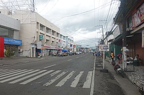
 N70 as Real Street in Ormoc | ||||
| Route information | ||||
| Auxiliary route of AH 26 (26) | ||||
| Maintained by Department of Public Works and Highways | ||||
| Component highways | ||||
| Major junctions | ||||
| From | ||||
| To | ||||
| Location | ||||
| Country | Philippines | |||
| Provinces | Leyte | |||
| Major cities | Ormoc, Baybay | |||
| Towns | Palo, Santa Fe, Alangalang, Jaro, Tunga, Carigara, Capoocan, Kananga, Albuera, Mahaplag | |||
| Highway system | ||||
| ||||
| ||||
The National Route 70 (N70) forms part of the Philippine highway network. It spurs the Asian Highway 26 in Leyte, Philippines.[1][2][3][4]
Route description
This section is empty. You can help by adding to it. |
Asian Highway Network
This route partially spurs the Asian Highway 26, running from Palo to Ormoc and continues as a sea ferry to Cebu City.[5]
References
- ^ "Leyte 1st". www.dpwh.gov.ph. Retrieved September 11, 2018.
- ^ "Leyte 2nd". www.dpwh.gov.ph. Retrieved September 11, 2018.
- ^ "Leyte 4th". www.dpwh.gov.ph. Retrieved September 11, 2018.
- ^ "Leyte 5th". www.dpwh.gov.ph. Retrieved September 11, 2018.
- ^ "What does AH26 road sign mean?". Rappler.com. November 17, 2014. Retrieved August 8, 2021.
External links

